Ohatchee Boat Launch
Community Reviews
Been here? Share the conditions.
Reviews, ratings & photos are added in the free Snoflo iOS app — rate a spot, tag the conditions, and your visit is verified by location. Add or manage your reviews from the app.
Ohatchee
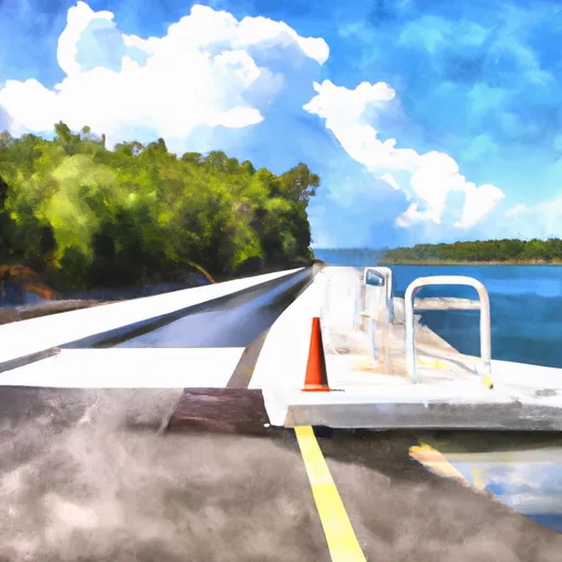
The Ohatchee boat ramp is a public facility that offers access to the Coosa River for recreational boating purposes. It is a popular spot for fishing, boating, and other water-based activities. The ramp itself is quite wide, allowing for multiple boats to be launched simultaneously. The specific width of the ramp is not available, but it appears to be large enough to accommodate a variety of watercraft.
As for the types of watercraft permitted on the Coosa River, the answer is somewhat complex. In general, most types of recreational boats are allowed on the river, including powerboats, sailboats, canoes, and kayaks. However, there are certain restrictions and regulations that apply to specific areas of the river, so it is important to check local regulations and guidelines before launching any type of watercraft.
In general, the Coosa River is known for its excellent fishing opportunities, particularly for bass and catfish. Anglers can also catch a variety of other fish species, including crappie, bluegill, and redear sunfish. The river is also popular for boating, water skiing, and other water-based activities.
Overall, the Ohatchee boat ramp is a great place to launch a watercraft and enjoy all that the Coosa River has to offer. It is a well-maintained facility that is open to the public, and it provides easy access to one of Alabama's most popular waterways.
Plan your launch down to the hour
Same weather feed Snoflo's iOS app uses -- updated continuously from NOAA / yr.no.
Next 5 days, hour by hour
Temperature line with weather symbols on top, snow + rain accumulation as columns, humidity as a dotted line.
5-day forecast table
Every 3 hours, broken out across temperature, snow, rain, humidity, and wind.
| Time | Condition | Temp (°F) | Snow (in) | Rain (in) | Humidity (%) | Wind (mps) | Wind dir |
|---|---|---|---|---|---|---|---|
| Loading detailed forecast… | |||||||
15-day temperature & precipitation
Daily temperatures, snow, and rain projected over the next two weeks.
Area streamflow levels
USGS streamgauges around Ohatchee -- the same readings that determine whether your launch is safe and your boat is the right craft.
| Streamgauge | Discharge | View |
|---|---|---|
| Big Canoe Creek At Ashville Al | 70 cfs | → |
| Choccolocco Creek At Jackson Shoal Nr Lincoln Al | 284 cfs | → |
| Choccolocco Creek Near Boiling Spring | 102 cfs | → |
| Big Wills Creek Near Reece City | 95 cfs | → |
| Blackburn Fork Little Warrior R Nr Holly Springs | 25 cfs | → |
| Kelly Creek Near Vincent Al | 54 cfs | → |
Plan a longer trip
The closest paddle runs, fishing spots, and other boat launches so you can extend a day on the water.
Boating safety & etiquette
- Check the conditions before you launch
- Use the streamflow numbers, weather, and wind forecast on this page. High-cfs whitewater requires whitewater-specific craft and skill.
- Wear your life jacket
- Statistically the single biggest survival factor in a boating incident. State law often requires one per passenger.
- File a float plan
- Tell someone on shore your put-in, take-out, and expected return time. Especially for multi-day or remote trips.
- Yield at the ramp
- Prep gear in the parking lot, not on the ramp. Launch and clear quickly so others can use the lane.
- Clean, drain, dry
- Inspect, clean, drain and dry your boat between waters to prevent the spread of aquatic invasive species.
Set push alerts in the Snoflo app
Save Ohatchee as a favorite, set a discharge threshold or a wind/precipitation alert, and the iOS app will push the moment conditions cross.
About Ohatchee
Can I launch a motorboat here?
Most Snoflo-tracked launches support motorboats; check the operator for any horsepower restrictions, paddle-only zones, or seasonal closures.
How fresh is the streamflow data?
USGS streamgauges report continuously (every 15 minutes); the table on this page pulls the latest reading at page load.
Is there a fee?
Many federal and state boat launches charge a day-use fee. Check the operator's site before driving out.
What boat is right for these conditions?
Use the nearby streamflow numbers and river-run panel on this page to gauge current conditions. Wider, slower water is friendly for casual paddling and powerboats; high-cfs whitewater requires whitewater-specific craft and skill.
Can I get alerts when conditions change?
Yes -- alerts are managed in the Snoflo iOS app. Favorite this launch, set a threshold (discharge, wind), and you'll get a push the moment it crosses.
Other launches near here
Snoflo-tracked boat launches within driving distance of Ohatchee.