War Eagle Drive, Dadeville Boat Launch
Community Reviews
Been here? Share the conditions.
Reviews, ratings & photos are added in the free Snoflo iOS app — rate a spot, tag the conditions, and your visit is verified by location. Add or manage your reviews from the app.
War Eagle Drive, Dadeville
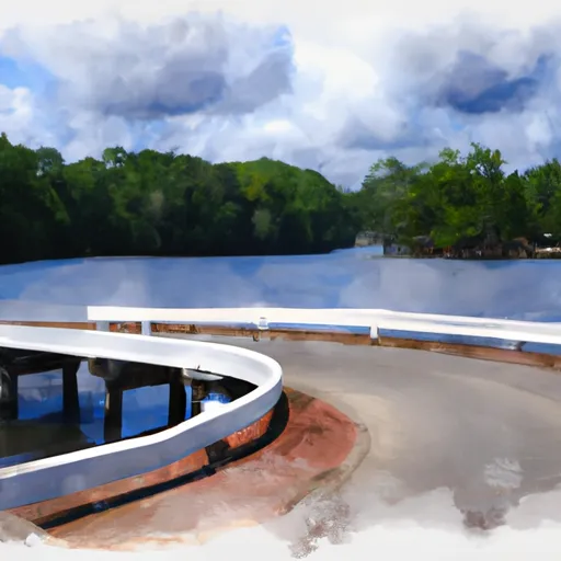
According to the latest information available, the War Eagle Drive boat ramp is a wide and spacious concrete ramp that is suitable for launching a variety of watercraft. It is approximately 30 feet wide and has a gentle slope, which makes it easy to launch and retrieve boats of all sizes.
The boat ramp is located at latitude: 32.79779816 and longitude: -85.81939697, and it is conveniently located near the intersection of War Eagle Drive and Highway 49. The ramp is open year-round, but it is important to note that there may be additional fees or restrictions during peak boating season.
As for the types of watercraft that are permitted on Lake Martin, the lake is open to a wide variety of recreational activities, including boating, fishing, swimming, and water sports. There are no specific restrictions on the types of boats that are allowed on the lake, but it is important to follow all applicable safety regulations and guidelines.
Overall, the War Eagle Drive boat ramp is a convenient and accessible option for anyone looking to launch their boat on Lake Martin in Dadeville, Alabama.
Plan your launch down to the hour
Same weather feed Snoflo's iOS app uses -- updated continuously from NOAA / yr.no.
Next 5 days, hour by hour
Temperature line with weather symbols on top, snow + rain accumulation as columns, humidity as a dotted line.
5-day forecast table
Every 3 hours, broken out across temperature, snow, rain, humidity, and wind.
| Time | Condition | Temp (°F) | Snow (in) | Rain (in) | Humidity (%) | Wind (mps) | Wind dir |
|---|---|---|---|---|---|---|---|
| Loading detailed forecast… | |||||||
15-day temperature & precipitation
Daily temperatures, snow, and rain projected over the next two weeks.
Area streamflow levels
USGS streamgauges around War Eagle Drive, Dadeville -- the same readings that determine whether your launch is safe and your boat is the right craft.
| Streamgauge | Discharge | View |
|---|---|---|
| Tallapoosa River Nr New Site | 864 cfs | → |
| Sougahatchee Creek At Co Rd 188 Nr Loachapoka | 22 cfs | → |
| Hillabee Creek Near Hackneyville Al | 91 cfs | → |
| Uphapee Creek Near Tuskegee Al | 72 cfs | → |
| Chewacla Creek At Chewacla State Park Nr Auburn | 13 cfs | → |
| Tallapoosa River At Wadley Al | 1,070 cfs | → |
Plan a longer trip
The closest paddle runs, fishing spots, and other boat launches so you can extend a day on the water.
Boating safety & etiquette
- Check the conditions before you launch
- Use the streamflow numbers, weather, and wind forecast on this page. High-cfs whitewater requires whitewater-specific craft and skill.
- Wear your life jacket
- Statistically the single biggest survival factor in a boating incident. State law often requires one per passenger.
- File a float plan
- Tell someone on shore your put-in, take-out, and expected return time. Especially for multi-day or remote trips.
- Yield at the ramp
- Prep gear in the parking lot, not on the ramp. Launch and clear quickly so others can use the lane.
- Clean, drain, dry
- Inspect, clean, drain and dry your boat between waters to prevent the spread of aquatic invasive species.
Set push alerts in the Snoflo app
Save War Eagle Drive, Dadeville as a favorite, set a discharge threshold or a wind/precipitation alert, and the iOS app will push the moment conditions cross.
About War Eagle Drive, Dadeville
Can I launch a motorboat here?
Most Snoflo-tracked launches support motorboats; check the operator for any horsepower restrictions, paddle-only zones, or seasonal closures.
How fresh is the streamflow data?
USGS streamgauges report continuously (every 15 minutes); the table on this page pulls the latest reading at page load.
Is there a fee?
Many federal and state boat launches charge a day-use fee. Check the operator's site before driving out.
What boat is right for these conditions?
Use the nearby streamflow numbers and river-run panel on this page to gauge current conditions. Wider, slower water is friendly for casual paddling and powerboats; high-cfs whitewater requires whitewater-specific craft and skill.
Can I get alerts when conditions change?
Yes -- alerts are managed in the Snoflo iOS app. Favorite this launch, set a threshold (discharge, wind), and you'll get a push the moment it crosses.
Other launches near here
Snoflo-tracked boat launches within driving distance of War Eagle Drive, Dadeville.