Cypremort Point, St. Mary Parish, Louisiana, Vs Boat Launch
Community Reviews
Been here? Share the conditions.
Reviews, ratings & photos are added in the free Snoflo iOS app — rate a spot, tag the conditions, and your visit is verified by location. Add or manage your reviews from the app.
Cypremort Point, St. Mary Parish, Louisiana, Vs
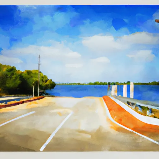
Cypremort Point is a popular recreational area in Louisiana that features a boat ramp that allows access to Vermilion Bay, which is a large body of water that is connected to the Gulf of Mexico. The boat ramp is approximately 65 feet wide, allowing for multiple boats to be launched at the same time.
According to the Louisiana Department of Wildlife and Fisheries, the boat ramp at Cypremort Point can accommodate boats of various sizes, including small fishing boats, pleasure boats, and larger vessels such as motorboats and sailboats. The area is also known for its excellent fishing opportunities, with a variety of fish species, including redfish, speckled trout, and flounder, being commonly caught in the surrounding waters.
In terms of facilities, Cypremort Point also has a fishing pier, picnic areas, and restrooms for visitors to use. It is a popular destination for boaters and fishermen alike and is known for its scenic beauty and tranquil atmosphere.
Plan your launch down to the hour
Same weather feed Snoflo's iOS app uses -- updated continuously from NOAA / yr.no.
Next 5 days, hour by hour
Temperature line with weather symbols on top, snow + rain accumulation as columns, humidity as a dotted line.
5-day forecast table
Every 3 hours, broken out across temperature, snow, rain, humidity, and wind.
| Time | Condition | Temp (°F) | Snow (in) | Rain (in) | Humidity (%) | Wind (mps) | Wind dir |
|---|---|---|---|---|---|---|---|
| Loading detailed forecast… | |||||||
15-day temperature & precipitation
Daily temperatures, snow, and rain projected over the next two weeks.
Area streamflow levels
USGS streamgauges around Cypremort Point, St. Mary Parish, Louisiana, Vs -- the same readings that determine whether your launch is safe and your boat is the right craft.
| Streamgauge | Discharge | View |
|---|---|---|
| Bayou Teche At Adeline Bridge Near Jeanerette | 221 cfs | → |
| Charenton Drainage Canal At Baldwin | 7,760 cfs | → |
| Giww At Bayou Sale Ridge Near Franklin | 8,250 cfs | → |
| Vermilion River At Perry | 1,910 cfs | → |
| Wax Lake Outlet At Calumet | 103,000 cfs | → |
Plan a longer trip
The closest paddle runs, fishing spots, and other boat launches so you can extend a day on the water.
Boating safety & etiquette
- Check the conditions before you launch
- Use the streamflow numbers, weather, and wind forecast on this page. High-cfs whitewater requires whitewater-specific craft and skill.
- Wear your life jacket
- Statistically the single biggest survival factor in a boating incident. State law often requires one per passenger.
- File a float plan
- Tell someone on shore your put-in, take-out, and expected return time. Especially for multi-day or remote trips.
- Yield at the ramp
- Prep gear in the parking lot, not on the ramp. Launch and clear quickly so others can use the lane.
- Clean, drain, dry
- Inspect, clean, drain and dry your boat between waters to prevent the spread of aquatic invasive species.
Set push alerts in the Snoflo app
Save Cypremort Point, St. Mary Parish, Louisiana, Vs as a favorite, set a discharge threshold or a wind/precipitation alert, and the iOS app will push the moment conditions cross.
About Cypremort Point, St. Mary Parish, Louisiana, Vs
Can I launch a motorboat here?
Most Snoflo-tracked launches support motorboats; check the operator for any horsepower restrictions, paddle-only zones, or seasonal closures.
How fresh is the streamflow data?
USGS streamgauges report continuously (every 15 minutes); the table on this page pulls the latest reading at page load.
Is there a fee?
Many federal and state boat launches charge a day-use fee. Check the operator's site before driving out.
What boat is right for these conditions?
Use the nearby streamflow numbers and river-run panel on this page to gauge current conditions. Wider, slower water is friendly for casual paddling and powerboats; high-cfs whitewater requires whitewater-specific craft and skill.
Can I get alerts when conditions change?
Yes -- alerts are managed in the Snoflo iOS app. Favorite this launch, set a threshold (discharge, wind), and you'll get a push the moment it crosses.
Other launches near here
Snoflo-tracked boat launches within driving distance of Cypremort Point, St. Mary Parish, Louisiana, Vs.