Whatcom County Boat Launch
Community Reviews
Been here? Share the conditions.
Reviews, ratings & photos are added in the free Snoflo iOS app — rate a spot, tag the conditions, and your visit is verified by location. Add or manage your reviews from the app.
Whatcom County
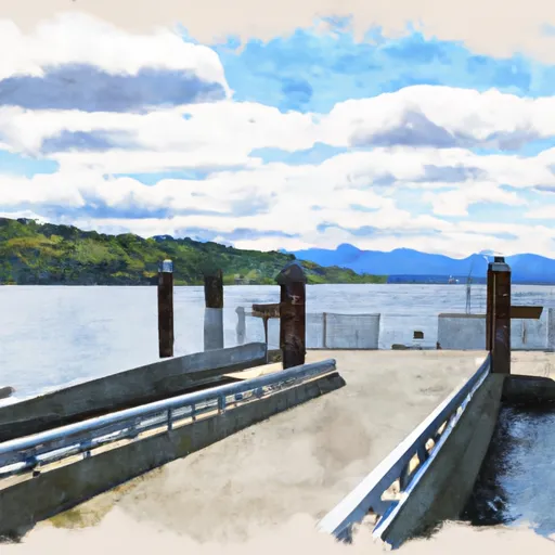
In summary, the Whatcom County boat ramp is a concrete single-lane ramp with a dock for loading and unloading. It is approximately 12 feet wide and provides access to the North Fork of the Nooksack River in Washington state. Only non-motorized crafts like canoes, kayaks, and rafts are allowed on the water. This information was obtained from the official website of Whatcom County Parks and Recreation and is accurate as of the time of writing.
Plan your launch down to the hour
Same weather feed Snoflo's iOS app uses -- updated continuously from NOAA / yr.no.
Next 5 days, hour by hour
Temperature line with weather symbols on top, snow + rain accumulation as columns, humidity as a dotted line.
5-day forecast table
Every 3 hours, broken out across temperature, snow, rain, humidity, and wind.
| Time | Condition | Temp (°F) | Snow (in) | Rain (in) | Humidity (%) | Wind (mps) | Wind dir |
|---|---|---|---|---|---|---|---|
| Loading detailed forecast… | |||||||
15-day temperature & precipitation
Daily temperatures, snow, and rain projected over the next two weeks.
Area streamflow levels
USGS streamgauges around Whatcom County -- the same readings that determine whether your launch is safe and your boat is the right craft.
| Streamgauge | Discharge | View |
|---|---|---|
| Skagit River Near Concrete | 11,300 cfs | → |
| Bacon Creek Below Oakes Creek Near Marblemount | 163 cfs | → |
| Skagit River At Marblemount | 4,650 cfs | → |
| Cascade River At Marblemount | 739 cfs | → |
| Sauk River Near Sauk | 2,080 cfs | → |
| Clearwater Creek Near Welcome | 39 cfs | → |
Plan a longer trip
The closest paddle runs, fishing spots, and other boat launches so you can extend a day on the water.
River runs
- Mt. Baker-Snoqualmie Nf/North Cascades Np Boundary To Baker Lake
- Blum Creek To Baker Lake
- Bell Creek To Mt. Baker-Snoqualmie Nf Boundary
- Mt. Baker-Snoqualmie Nf/North Cascades Np Boundary To Confluence With Blum Creek
- Headwaters To Confluence With Bell Creek
- Headwaters In Ne1/4 Of Sec 23, T37n, R7e To Confluence With Soufh Fork Nooksack River
Boating safety & etiquette
- Check the conditions before you launch
- Use the streamflow numbers, weather, and wind forecast on this page. High-cfs whitewater requires whitewater-specific craft and skill.
- Wear your life jacket
- Statistically the single biggest survival factor in a boating incident. State law often requires one per passenger.
- File a float plan
- Tell someone on shore your put-in, take-out, and expected return time. Especially for multi-day or remote trips.
- Yield at the ramp
- Prep gear in the parking lot, not on the ramp. Launch and clear quickly so others can use the lane.
- Clean, drain, dry
- Inspect, clean, drain and dry your boat between waters to prevent the spread of aquatic invasive species.
Set push alerts in the Snoflo app
Save Whatcom County as a favorite, set a discharge threshold or a wind/precipitation alert, and the iOS app will push the moment conditions cross.
About Whatcom County
Can I launch a motorboat here?
Most Snoflo-tracked launches support motorboats; check the operator for any horsepower restrictions, paddle-only zones, or seasonal closures.
How fresh is the streamflow data?
USGS streamgauges report continuously (every 15 minutes); the table on this page pulls the latest reading at page load.
Is there a fee?
Many federal and state boat launches charge a day-use fee. Check the operator's site before driving out.
What boat is right for these conditions?
Use the nearby streamflow numbers and river-run panel on this page to gauge current conditions. Wider, slower water is friendly for casual paddling and powerboats; high-cfs whitewater requires whitewater-specific craft and skill.
Can I get alerts when conditions change?
Yes -- alerts are managed in the Snoflo iOS app. Favorite this launch, set a threshold (discharge, wind), and you'll get a push the moment it crosses.
Other launches near here
Snoflo-tracked boat launches within driving distance of Whatcom County.