Jasper Riverwalk, Jasper Boat Launch
Community Reviews
Been here? Share the conditions.
Reviews, ratings & photos are added in the free Snoflo iOS app — rate a spot, tag the conditions, and your visit is verified by location. Add or manage your reviews from the app.
Jasper Riverwalk, Jasper
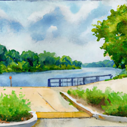
The ramp is fairly wide, allowing for several boats to be launched at once. The exact width of the ramp is not specified, but it is wide enough to accommodate larger boats and trailers. The surrounding area is also spacious, providing ample room for boats and trailers to be parked while their owners are out on the water.
The Patoka River, which is serviced by the Jasper Riverwalk boat ramp, is a popular destination for kayakers, canoers, and fishermen. The river boasts a variety of fish, including bass, catfish, and crappie. The river is also surrounded by beautiful scenery, making it a popular spot for outdoor enthusiasts.
The watercraft that are permitted on the Patoka River vary depending on the season and water level. Generally, canoes, kayaks, fishing boats, and motorized boats are all allowed on the river. However, during periods of low water, some areas may be too shallow for larger boats to pass through.
In conclusion, the Jasper Riverwalk boat ramp in Indiana is a well-maintained, concrete structure that provides easy access to the nearby Patoka River. The ramp is wide enough to accommodate larger boats and trailers, and the surrounding area is spacious enough to accommodate multiple boats and trailers. The Patoka River is a popular destination for kayakers, canoers, and fishermen, and a variety of watercraft are allowed on the river, depending on the season and water level.
Plan your launch down to the hour
Same weather feed Snoflo's iOS app uses -- updated continuously from NOAA / yr.no.
Next 5 days, hour by hour
Temperature line with weather symbols on top, snow + rain accumulation as columns, humidity as a dotted line.
5-day forecast table
Every 3 hours, broken out across temperature, snow, rain, humidity, and wind.
| Time | Condition | Temp (°F) | Snow (in) | Rain (in) | Humidity (%) | Wind (mps) | Wind dir |
|---|---|---|---|---|---|---|---|
| Loading detailed forecast… | |||||||
15-day temperature & precipitation
Daily temperatures, snow, and rain projected over the next two weeks.
Area streamflow levels
USGS streamgauges around Jasper Riverwalk, Jasper -- the same readings that determine whether your launch is safe and your boat is the right craft.
| Streamgauge | Discharge | View |
|---|---|---|
| Patoka River At Jasper | 242 cfs | → |
| Patoka River At Winslow | 492 cfs | → |
| White River Above Petersburg | 1,500 cfs | → |
| Middle Fork Anderson River At Bristow | 16 cfs | → |
| East Fork White River At Shoals | 4,720 cfs | → |
| White River At Petersburg | 11,000 cfs | → |
Plan a longer trip
The closest paddle runs, fishing spots, and other boat launches so you can extend a day on the water.
River runs
- State Road 56 Bridge To Forest Purchase Boundary At Roland, In
- State Road 337 Bridge To State Road 56 Bridge At Prospect, In
- City Limits Of English, In To Carnes Mill Site In Ne1/4ne1/4 Of Sec 13, T3s, R1w
- Carnes Mill Site To 7.65 Miles Above Confluece With Ohio River At Confluence With Turkey Creek
- Junction Of North/South Forks Of Lost River To State Road 337 Bridge, Approx 4 Miles Southeast Of Orleans, In
Boating safety & etiquette
- Check the conditions before you launch
- Use the streamflow numbers, weather, and wind forecast on this page. High-cfs whitewater requires whitewater-specific craft and skill.
- Wear your life jacket
- Statistically the single biggest survival factor in a boating incident. State law often requires one per passenger.
- File a float plan
- Tell someone on shore your put-in, take-out, and expected return time. Especially for multi-day or remote trips.
- Yield at the ramp
- Prep gear in the parking lot, not on the ramp. Launch and clear quickly so others can use the lane.
- Clean, drain, dry
- Inspect, clean, drain and dry your boat between waters to prevent the spread of aquatic invasive species.
Set push alerts in the Snoflo app
Save Jasper Riverwalk, Jasper as a favorite, set a discharge threshold or a wind/precipitation alert, and the iOS app will push the moment conditions cross.
About Jasper Riverwalk, Jasper
Can I launch a motorboat here?
Most Snoflo-tracked launches support motorboats; check the operator for any horsepower restrictions, paddle-only zones, or seasonal closures.
How fresh is the streamflow data?
USGS streamgauges report continuously (every 15 minutes); the table on this page pulls the latest reading at page load.
Is there a fee?
Many federal and state boat launches charge a day-use fee. Check the operator's site before driving out.
What boat is right for these conditions?
Use the nearby streamflow numbers and river-run panel on this page to gauge current conditions. Wider, slower water is friendly for casual paddling and powerboats; high-cfs whitewater requires whitewater-specific craft and skill.
Can I get alerts when conditions change?
Yes -- alerts are managed in the Snoflo iOS app. Favorite this launch, set a threshold (discharge, wind), and you'll get a push the moment it crosses.
Other launches near here
Snoflo-tracked boat launches within driving distance of Jasper Riverwalk, Jasper.