State Route 6 Maine Boat Launch
Community Reviews
Been here? Share the conditions.
Reviews, ratings & photos are added in the free Snoflo iOS app — rate a spot, tag the conditions, and your visit is verified by location. Add or manage your reviews from the app.
State Route 6 Maine
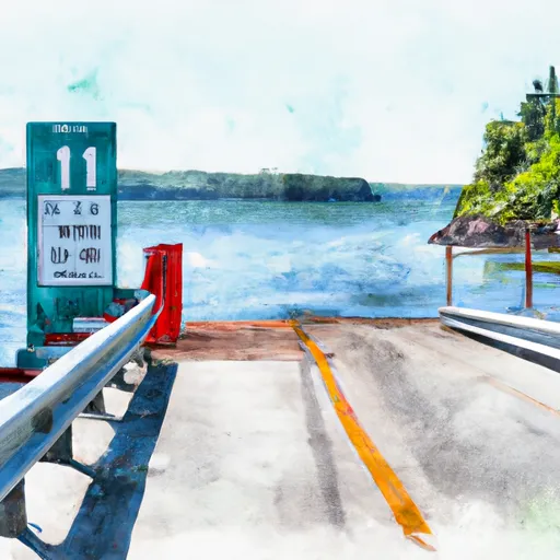
The width of the ramp is not specifically mentioned in the available information, but it is reported to be in good condition and capable of accommodating a variety of boats. It is unclear if the ramp is ADA compliant.
The boat ramp services the Sebasticook Lake, which is a freshwater lake located in central Maine. This lake is known for its bass fishing and is a popular destination for recreational boating, fishing, and swimming.
Regarding the kind of craft permitted on the water, the latest information available indicates that powerboats, canoes, kayaks, and other small watercraft are permitted on the lake. However, there may be certain restrictions or regulations in place regarding the use of certain types of watercraft or motor sizes, so it is always best to check with the local authorities before launching any watercraft.
In summary, the State Route 6 Maine boat ramp is a concrete ramp that services the Sebasticook Lake in central Maine. It is suitable for small to medium-sized watercraft and permits a variety of boats, including powerboats, canoes, and kayaks. The width of the ramp is not specifically mentioned, but it is reported to be in good condition.
Plan your launch down to the hour
Same weather feed Snoflo's iOS app uses -- updated continuously from NOAA / yr.no.
Next 5 days, hour by hour
Temperature line with weather symbols on top, snow + rain accumulation as columns, humidity as a dotted line.
5-day forecast table
Every 3 hours, broken out across temperature, snow, rain, humidity, and wind.
| Time | Condition | Temp (°F) | Snow (in) | Rain (in) | Humidity (%) | Wind (mps) | Wind dir |
|---|---|---|---|---|---|---|---|
| Loading detailed forecast… | |||||||
15-day temperature & precipitation
Daily temperatures, snow, and rain projected over the next two weeks.
Area streamflow levels
USGS streamgauges around State Route 6 Maine -- the same readings that determine whether your launch is safe and your boat is the right craft.
| Streamgauge | Discharge | View |
|---|---|---|
| Piscataquis River At Blanchard | 14 cfs | → |
| Kennebec River At The Forks | 488 cfs | → |
| Kingsbury Stream At Abbot Village | 14 cfs | → |
| Piscataquis River Near Dover-Foxcroft | 41 cfs | → |
| Spencer Stream At Mouth | 58 cfs | → |
Plan a longer trip
The closest paddle runs, fishing spots, and other boat launches so you can extend a day on the water.
River runs
- Kennebec Gorge
- Headwaters To Mouth At West Branch Pleasant River
- Lobster Lake To Confluence With West Branch
- Golden Road Bridge (Approx. 2 Miles Below Lobster Stream) To Confluence With Pine Stream
- Pittston Farm To Golden Road Bridge (Approx. 2 Miles Below Lobster Stream)
- Canada Falls Lake To Pittston Farm
Boating safety & etiquette
- Check the conditions before you launch
- Use the streamflow numbers, weather, and wind forecast on this page. High-cfs whitewater requires whitewater-specific craft and skill.
- Wear your life jacket
- Statistically the single biggest survival factor in a boating incident. State law often requires one per passenger.
- File a float plan
- Tell someone on shore your put-in, take-out, and expected return time. Especially for multi-day or remote trips.
- Yield at the ramp
- Prep gear in the parking lot, not on the ramp. Launch and clear quickly so others can use the lane.
- Clean, drain, dry
- Inspect, clean, drain and dry your boat between waters to prevent the spread of aquatic invasive species.
Set push alerts in the Snoflo app
Save State Route 6 Maine as a favorite, set a discharge threshold or a wind/precipitation alert, and the iOS app will push the moment conditions cross.
About State Route 6 Maine
Can I launch a motorboat here?
Most Snoflo-tracked launches support motorboats; check the operator for any horsepower restrictions, paddle-only zones, or seasonal closures.
How fresh is the streamflow data?
USGS streamgauges report continuously (every 15 minutes); the table on this page pulls the latest reading at page load.
Is there a fee?
Many federal and state boat launches charge a day-use fee. Check the operator's site before driving out.
What boat is right for these conditions?
Use the nearby streamflow numbers and river-run panel on this page to gauge current conditions. Wider, slower water is friendly for casual paddling and powerboats; high-cfs whitewater requires whitewater-specific craft and skill.
Can I get alerts when conditions change?
Yes -- alerts are managed in the Snoflo iOS app. Favorite this launch, set a threshold (discharge, wind), and you'll get a push the moment it crosses.
Other launches near here
Snoflo-tracked boat launches within driving distance of State Route 6 Maine.