Black Walnut Bottom Boat Launch
Community Reviews
Been here? Share the conditions.
Reviews, ratings & photos are added in the free Snoflo iOS app — rate a spot, tag the conditions, and your visit is verified by location. Add or manage your reviews from the app.
Black Walnut Bottom
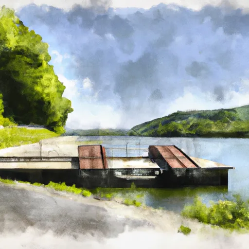
According to the Pennsylvania Fish and Boat Commission, the Black Walnut Bottom boat ramp is 18 feet wide, making it suitable for smaller watercraft such as canoes, kayaks, and small fishing boats. The ramp is also suitable for trailers and larger boats, but it may be necessary to launch them in stages due to the narrow width of the ramp.
The Tioga River is a popular destination for fishing, particularly for trout, bass, and panfish. The river is also suitable for recreational paddling and kayaking, although water levels can vary significantly depending on the weather and other factors.
In terms of regulations, all boats using Black Walnut Bottom boat ramp must be registered and have a valid Pennsylvania Fish and Boat Commission registration sticker. Additionally, all boats must comply with state and federal regulations for safety equipment, including life jackets, navigation lights, and fire extinguishers.
Overall, Black Walnut Bottom boat ramp is a small but important access point for recreational boaters and anglers looking to explore the Tioga River.
Plan your launch down to the hour
Same weather feed Snoflo's iOS app uses -- updated continuously from NOAA / yr.no.
Next 5 days, hour by hour
Temperature line with weather symbols on top, snow + rain accumulation as columns, humidity as a dotted line.
5-day forecast table
Every 3 hours, broken out across temperature, snow, rain, humidity, and wind.
| Time | Condition | Temp (°F) | Snow (in) | Rain (in) | Humidity (%) | Wind (mps) | Wind dir |
|---|---|---|---|---|---|---|---|
| Loading detailed forecast… | |||||||
15-day temperature & precipitation
Daily temperatures, snow, and rain projected over the next two weeks.
Area streamflow levels
USGS streamgauges around Black Walnut Bottom -- the same readings that determine whether your launch is safe and your boat is the right craft.
| Streamgauge | Discharge | View |
|---|---|---|
| Pine Creek At Cedar Run | 146 cfs | → |
| Young Womans Creek Near Renovo | 10 cfs | → |
| West Branch Susquehanna River At Renovo | 6,890 cfs | → |
| Blockhouse Creek Near English Center | 4 cfs | → |
| Pine Creek Bl L Pine Creek Near Waterville | 203 cfs | → |
| Kettle Creek At Cross Fork | 33 cfs | → |
Plan a longer trip
The closest paddle runs, fishing spots, and other boat launches so you can extend a day on the water.
Boating safety & etiquette
- Check the conditions before you launch
- Use the streamflow numbers, weather, and wind forecast on this page. High-cfs whitewater requires whitewater-specific craft and skill.
- Wear your life jacket
- Statistically the single biggest survival factor in a boating incident. State law often requires one per passenger.
- File a float plan
- Tell someone on shore your put-in, take-out, and expected return time. Especially for multi-day or remote trips.
- Yield at the ramp
- Prep gear in the parking lot, not on the ramp. Launch and clear quickly so others can use the lane.
- Clean, drain, dry
- Inspect, clean, drain and dry your boat between waters to prevent the spread of aquatic invasive species.
Set push alerts in the Snoflo app
Save Black Walnut Bottom as a favorite, set a discharge threshold or a wind/precipitation alert, and the iOS app will push the moment conditions cross.
About Black Walnut Bottom
Can I launch a motorboat here?
Most Snoflo-tracked launches support motorboats; check the operator for any horsepower restrictions, paddle-only zones, or seasonal closures.
How fresh is the streamflow data?
USGS streamgauges report continuously (every 15 minutes); the table on this page pulls the latest reading at page load.
Is there a fee?
Many federal and state boat launches charge a day-use fee. Check the operator's site before driving out.
What boat is right for these conditions?
Use the nearby streamflow numbers and river-run panel on this page to gauge current conditions. Wider, slower water is friendly for casual paddling and powerboats; high-cfs whitewater requires whitewater-specific craft and skill.
Can I get alerts when conditions change?
Yes -- alerts are managed in the Snoflo iOS app. Favorite this launch, set a threshold (discharge, wind), and you'll get a push the moment it crosses.
Other launches near here
Snoflo-tracked boat launches within driving distance of Black Walnut Bottom.