Malinda Ferry Road, Rogersville Boat Launch
Community Reviews
Been here? Share the conditions.
Reviews, ratings & photos are added in the free Snoflo iOS app — rate a spot, tag the conditions, and your visit is verified by location. Add or manage your reviews from the app.
Malinda Ferry Road, Rogersville
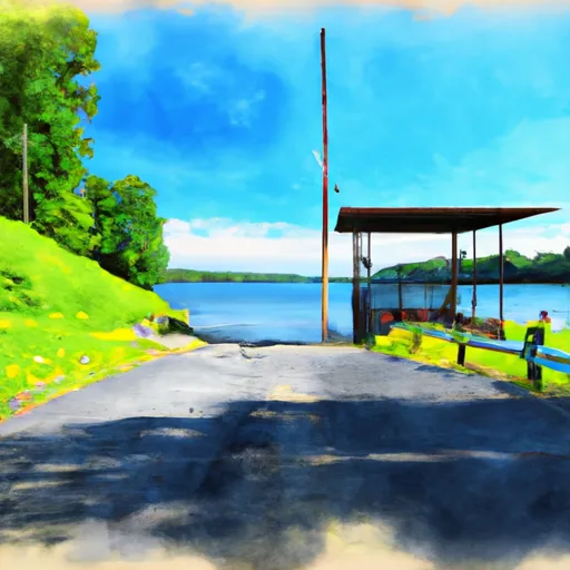
According to the latest information available, Malinda Ferry Road boat ramp is a concrete ramp and it is 24 feet wide. The ramp has a gentle slope, making it easy for boats to enter and exit the water. The parking lot adjacent to the ramp can accommodate up to 60 vehicles and trailers.
The body of water serviced by Malinda Ferry Road boat ramp is Cherokee Lake, which is a reservoir created by the TVA Cherokee Dam on the Holston River. The lake covers an area of over 30,000 acres and has over 400 miles of shoreline. It is a popular destination for boating, fishing, and other water-based activities.
As for the types of craft permitted on the water, there are no specific restrictions mentioned for Malinda Ferry Road boat ramp. However, TWRA regulations state that all boats operating on Tennessee waters must be registered and have a current decal displayed. Additionally, all boats must have the required safety equipment on board and follow all applicable boating laws and regulations.
In conclusion, Malinda Ferry Road boat ramp is a well-maintained concrete ramp in Rogersville, Tennessee that provides access to Cherokee Lake. It is 24 feet wide and can accommodate a variety of boats. With ample parking and a gentle slope, it is a popular launching point for boaters and anglers in the area.
Plan your launch down to the hour
Same weather feed Snoflo's iOS app uses -- updated continuously from NOAA / yr.no.
Next 5 days, hour by hour
Temperature line with weather symbols on top, snow + rain accumulation as columns, humidity as a dotted line.
5-day forecast table
Every 3 hours, broken out across temperature, snow, rain, humidity, and wind.
| Time | Condition | Temp (°F) | Snow (in) | Rain (in) | Humidity (%) | Wind (mps) | Wind dir |
|---|---|---|---|---|---|---|---|
| Loading detailed forecast… | |||||||
15-day temperature & precipitation
Daily temperatures, snow, and rain projected over the next two weeks.
Area streamflow levels
USGS streamgauges around Malinda Ferry Road, Rogersville -- the same readings that determine whether your launch is safe and your boat is the right craft.
| Streamgauge | Discharge | View |
|---|---|---|
| Crockett Creek Below Rogersville | 4 cfs | → |
| Big Creek Near Rogersville | 36 cfs | → |
| Clinch River Near Looneys Gap | 1,750 cfs | → |
| Nolichucky River Near Lowland | 2,410 cfs | → |
| Clinch River Above Tazewell | 1,380 cfs | → |
| Powell River Near Jonesville | 596 cfs | → |
Plan a longer trip
The closest paddle runs, fishing spots, and other boat launches so you can extend a day on the water.
Boating safety & etiquette
- Check the conditions before you launch
- Use the streamflow numbers, weather, and wind forecast on this page. High-cfs whitewater requires whitewater-specific craft and skill.
- Wear your life jacket
- Statistically the single biggest survival factor in a boating incident. State law often requires one per passenger.
- File a float plan
- Tell someone on shore your put-in, take-out, and expected return time. Especially for multi-day or remote trips.
- Yield at the ramp
- Prep gear in the parking lot, not on the ramp. Launch and clear quickly so others can use the lane.
- Clean, drain, dry
- Inspect, clean, drain and dry your boat between waters to prevent the spread of aquatic invasive species.
Set push alerts in the Snoflo app
Save Malinda Ferry Road, Rogersville as a favorite, set a discharge threshold or a wind/precipitation alert, and the iOS app will push the moment conditions cross.
About Malinda Ferry Road, Rogersville
Can I launch a motorboat here?
Most Snoflo-tracked launches support motorboats; check the operator for any horsepower restrictions, paddle-only zones, or seasonal closures.
How fresh is the streamflow data?
USGS streamgauges report continuously (every 15 minutes); the table on this page pulls the latest reading at page load.
Is there a fee?
Many federal and state boat launches charge a day-use fee. Check the operator's site before driving out.
What boat is right for these conditions?
Use the nearby streamflow numbers and river-run panel on this page to gauge current conditions. Wider, slower water is friendly for casual paddling and powerboats; high-cfs whitewater requires whitewater-specific craft and skill.
Can I get alerts when conditions change?
Yes -- alerts are managed in the Snoflo iOS app. Favorite this launch, set a threshold (discharge, wind), and you'll get a push the moment it crosses.
Other launches near here
Snoflo-tracked boat launches within driving distance of Malinda Ferry Road, Rogersville.