Lake Butte Des Morts -- Ninth Street Boat Launch boat launch
Community Reviews
Been here? Share the conditions.
Reviews, ratings & photos are added in the free Snoflo iOS app — rate a spot, tag the conditions, and your visit is verified by location. Add or manage your reviews from the app.
Lake Butte Des Morts -- Ninth Street Boat Launch
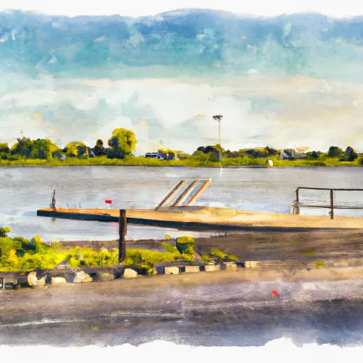
The boat ramp is a concrete ramp with a single lane, suitable for launching boats up to 22 feet in length. It is 20 feet wide, providing ample space for launching and retrieving boats. According to the latest information available, the boat ramp is in good condition and well-maintained by the local authorities.
Lake Butte Des Morts -- Ninth Street Boat Launch is open year-round, from sunrise to sunset. It is free to use for all visitors, although a daily or annual Wisconsin State Parks sticker is required for all vehicles parked at the site.
The body of water serviced by this boat ramp is Lake Butte Des Morts, which is part of the Winnebago System of lakes and rivers. The lake is popular for its varied fishing opportunities, including walleye, musky, northern pike, and panfish. It is also a great spot for recreational boating, including water sports like skiing, tubing, and wakeboarding.
The Wisconsin Department of Natural Resources regulates the types of craft allowed on Lake Butte Des Morts. Motorized watercrafts, such as powerboats and jet skis, are permitted on the lake, as well as non-motorized crafts like canoes, kayaks, and stand-up paddleboards. All boats are subject to Wisconsin boating laws and regulations, including registration and safety requirements.
Overall, Lake Butte Des Morts -- Ninth Street Boat Launch is a well-maintained and accessible boat ramp that provides convenient access to Lake Butte Des Morts for a variety of boaters and anglers.
Plan your launch down to the hour
Same weather feed Snoflo's iOS app uses -- updated continuously from NOAA / yr.no.
Next 5 days, hour by hour
Temperature line with weather symbols on top, snow + rain accumulation as columns, humidity as a dotted line.
5-day forecast table
Every 3 hours, broken out across temperature, snow, rain, humidity, and wind.
| Time | Condition | Temp (°F) | Snow (in) | Rain (in) | Humidity (%) | Wind (mps) | Wind dir |
|---|---|---|---|---|---|---|---|
| Loading detailed forecast… | |||||||
15-day temperature & precipitation
Daily temperatures, snow, and rain projected over the next two weeks.
Area streamflow levels
USGS streamgauges around Lake Butte Des Morts -- Ninth Street Boat Launch -- the same readings that determine whether your launch is safe and your boat is the right craft.
| Streamgauge | Discharge | View |
|---|---|---|
| Fox River At Appleton | 2,500 cfs | → |
| Fox River At Oshkosh | 3,170 cfs | → |
| Wolf River At New London | 1,590 cfs | → |
| East River At Ct Highway Zz Near Greenleaf | 1 cfs | → |
| Little Wolf River At Royalton | -999,999 cfs | → |
| Duck Creek Near Howard | 27 cfs | → |
Plan a longer trip
The closest paddle runs, fishing spots, and other boat launches so you can extend a day on the water.
Boating safety & etiquette
- Check the conditions before you launch
- Use the streamflow numbers, weather, and wind forecast on this page. High-cfs whitewater requires whitewater-specific craft and skill.
- Wear your life jacket
- Statistically the single biggest survival factor in a boating incident. State law often requires one per passenger.
- File a float plan
- Tell someone on shore your put-in, take-out, and expected return time. Especially for multi-day or remote trips.
- Yield at the ramp
- Prep gear in the parking lot, not on the ramp. Launch and clear quickly so others can use the lane.
- Clean, drain, dry
- Inspect, clean, drain and dry your boat between waters to prevent the spread of aquatic invasive species.
Set push alerts in the Snoflo app
Save Lake Butte Des Morts -- Ninth Street Boat Launch as a favorite, set a discharge threshold or a wind/precipitation alert, and the iOS app will push the moment conditions cross.
About Lake Butte Des Morts -- Ninth Street Boat Launch
Can I launch a motorboat here?
Most Snoflo-tracked launches support motorboats; check the operator for any horsepower restrictions, paddle-only zones, or seasonal closures.
How fresh is the streamflow data?
USGS streamgauges report continuously (every 15 minutes); the table on this page pulls the latest reading at page load.
Is there a fee?
Many federal and state boat launches charge a day-use fee. Check the operator's site before driving out.
What boat is right for these conditions?
Use the nearby streamflow numbers and river-run panel on this page to gauge current conditions. Wider, slower water is friendly for casual paddling and powerboats; high-cfs whitewater requires whitewater-specific craft and skill.
Can I get alerts when conditions change?
Yes -- alerts are managed in the Snoflo iOS app. Favorite this launch, set a threshold (discharge, wind), and you'll get a push the moment it crosses.
Other launches near here
Snoflo-tracked boat launches within driving distance of Lake Butte Des Morts -- Ninth Street Boat Launch.