Kewaunee River -- Boat Ramp - Cth E boat launch
Community Reviews
Been here? Share the conditions.
Reviews, ratings & photos are added in the free Snoflo iOS app — rate a spot, tag the conditions, and your visit is verified by location. Add or manage your reviews from the app.
Kewaunee River -- Boat Ramp - Cth E
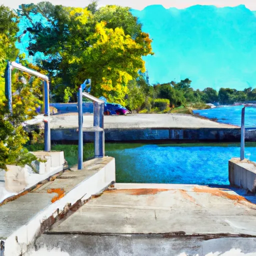
The Kewaunee River Boat Ramp is suitable for launching small and medium-sized boats, including fishing boats, pleasure boats, and jet skis. However, larger vessels may have difficulty navigating the steep incline and narrow ramp. The water depth at the ramp varies based on the water level of the Kewaunee River and Lake Michigan.
According to the latest information available, the Kewaunee River Boat Ramp - Cth E is open year-round and is free to use. However, users are required to obtain a Wisconsin state parks sticker to park their vehicle in the lot. The ramp is maintained by the Kewaunee County Parks Department, and users are advised to check for any updates or closures before heading to the ramp.
In summary, the Kewaunee River Boat Ramp - Cth E is a concrete, single-lane boat ramp located in Kewaunee County, Wisconsin. It provides access to the Kewaunee River and Lake Michigan and is suitable for launching small and medium-sized boats. The ramp is approximately 20 feet wide and has a parking lot that can accommodate up to 20 vehicles with trailers. The ramp is open year-round and is free to use, but users are required to obtain a Wisconsin state parks sticker to park their vehicle in the lot.
Plan your launch down to the hour
Same weather feed Snoflo's iOS app uses -- updated continuously from NOAA / yr.no.
Next 5 days, hour by hour
Temperature line with weather symbols on top, snow + rain accumulation as columns, humidity as a dotted line.
5-day forecast table
Every 3 hours, broken out across temperature, snow, rain, humidity, and wind.
| Time | Condition | Temp (°F) | Snow (in) | Rain (in) | Humidity (%) | Wind (mps) | Wind dir |
|---|---|---|---|---|---|---|---|
| Loading detailed forecast… | |||||||
15-day temperature & precipitation
Daily temperatures, snow, and rain projected over the next two weeks.
Area streamflow levels
USGS streamgauges around Kewaunee River -- Boat Ramp - Cth E -- the same readings that determine whether your launch is safe and your boat is the right craft.
| Streamgauge | Discharge | View |
|---|---|---|
| Kewaunee River Near Kewaunee | 39 cfs | → |
| Fox River At Oil Tank Depot At Green Bay | 606 cfs | → |
| Manitowoc River At Manitowoc | 65 cfs | → |
| East River At Ct Highway Zz Near Greenleaf | 2 cfs | → |
| Duck Creek Near Howard | 27 cfs | → |
Plan a longer trip
The closest paddle runs, fishing spots, and other boat launches so you can extend a day on the water.
Boating safety & etiquette
- Check the conditions before you launch
- Use the streamflow numbers, weather, and wind forecast on this page. High-cfs whitewater requires whitewater-specific craft and skill.
- Wear your life jacket
- Statistically the single biggest survival factor in a boating incident. State law often requires one per passenger.
- File a float plan
- Tell someone on shore your put-in, take-out, and expected return time. Especially for multi-day or remote trips.
- Yield at the ramp
- Prep gear in the parking lot, not on the ramp. Launch and clear quickly so others can use the lane.
- Clean, drain, dry
- Inspect, clean, drain and dry your boat between waters to prevent the spread of aquatic invasive species.
Set push alerts in the Snoflo app
Save Kewaunee River -- Boat Ramp - Cth E as a favorite, set a discharge threshold or a wind/precipitation alert, and the iOS app will push the moment conditions cross.
About Kewaunee River -- Boat Ramp - Cth E
Can I launch a motorboat here?
Most Snoflo-tracked launches support motorboats; check the operator for any horsepower restrictions, paddle-only zones, or seasonal closures.
How fresh is the streamflow data?
USGS streamgauges report continuously (every 15 minutes); the table on this page pulls the latest reading at page load.
Is there a fee?
Many federal and state boat launches charge a day-use fee. Check the operator's site before driving out.
What boat is right for these conditions?
Use the nearby streamflow numbers and river-run panel on this page to gauge current conditions. Wider, slower water is friendly for casual paddling and powerboats; high-cfs whitewater requires whitewater-specific craft and skill.
Can I get alerts when conditions change?
Yes -- alerts are managed in the Snoflo iOS app. Favorite this launch, set a threshold (discharge, wind), and you'll get a push the moment it crosses.
Other launches near here
Snoflo-tracked boat launches within driving distance of Kewaunee River -- Boat Ramp - Cth E.