Saint Croix River -- North Hudson Ferry Landing Park Boat Launch
Community Reviews
Been here? Share the conditions.
Reviews, ratings & photos are added in the free Snoflo iOS app — rate a spot, tag the conditions, and your visit is verified by location. Add or manage your reviews from the app.
Saint Croix River -- North Hudson Ferry Landing Park
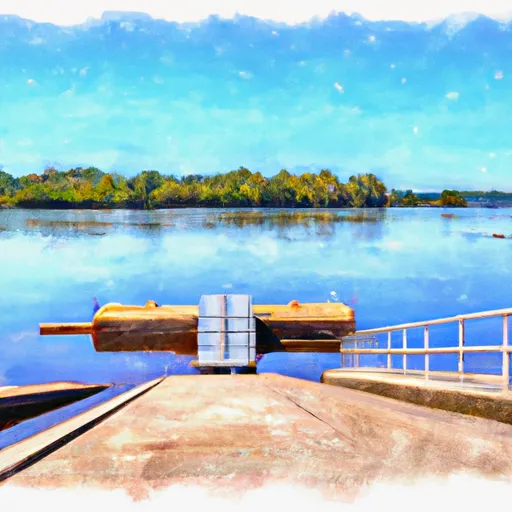
According to the latest information available, the boat ramp is a concrete ramp that is approximately 20 feet wide and extends into the water at a gradual slope. There are also several parking spaces available for vehicles and trailers, and the park is equipped with restrooms, picnic tables, and other amenities to make it a comfortable and enjoyable place for boaters and other visitors.
The Saint Croix River is a popular destination for boaters and outdoor enthusiasts, with numerous opportunities for fishing, boating, and other recreational activities. The river is approximately 169 miles long and flows through the states of Wisconsin and Minnesota, offering a scenic and diverse landscape that includes forests, bluffs, and wetlands.
In terms of craft permitted on the water, the Saint Croix River -- North Hudson Ferry Landing Park boat ramp allows for a variety of watercraft, including motorized boats, canoes, kayaks, and paddleboards. It is important for boaters to be aware of local regulations and safety guidelines, such as wearing life jackets and avoiding alcohol consumption while operating a watercraft.
Plan your launch down to the hour
Same weather feed Snoflo's iOS app uses -- updated continuously from NOAA / yr.no.
Next 5 days, hour by hour
Temperature line with weather symbols on top, snow + rain accumulation as columns, humidity as a dotted line.
5-day forecast table
Every 3 hours, broken out across temperature, snow, rain, humidity, and wind.
| Time | Condition | Temp (°F) | Snow (in) | Rain (in) | Humidity (%) | Wind (mps) | Wind dir |
|---|---|---|---|---|---|---|---|
| Loading detailed forecast… | |||||||
15-day temperature & precipitation
Daily temperatures, snow, and rain projected over the next two weeks.
Area streamflow levels
USGS streamgauges around Saint Croix River -- North Hudson Ferry Landing Park -- the same readings that determine whether your launch is safe and your boat is the right craft.
| Streamgauge | Discharge | View |
|---|---|---|
| Willow River @ Willow R State Park Nr Burkhardt | 130 cfs | → |
| Kinnickinnic River Near River Falls | 91 cfs | → |
| Mississippi River At St. Paul | 4,810 cfs | → |
| Mississippi River At Prescott | 10,900 cfs | → |
| Mississippi River Below L&D #2 At Hastings | 7,990 cfs | → |
| Minnesota River At Fort Snelling State Park | 6,620 cfs | → |
Plan a longer trip
The closest paddle runs, fishing spots, and other boat launches so you can extend a day on the water.
Boating safety & etiquette
- Check the conditions before you launch
- Use the streamflow numbers, weather, and wind forecast on this page. High-cfs whitewater requires whitewater-specific craft and skill.
- Wear your life jacket
- Statistically the single biggest survival factor in a boating incident. State law often requires one per passenger.
- File a float plan
- Tell someone on shore your put-in, take-out, and expected return time. Especially for multi-day or remote trips.
- Yield at the ramp
- Prep gear in the parking lot, not on the ramp. Launch and clear quickly so others can use the lane.
- Clean, drain, dry
- Inspect, clean, drain and dry your boat between waters to prevent the spread of aquatic invasive species.
Set push alerts in the Snoflo app
Save Saint Croix River -- North Hudson Ferry Landing Park as a favorite, set a discharge threshold or a wind/precipitation alert, and the iOS app will push the moment conditions cross.
About Saint Croix River -- North Hudson Ferry Landing Park
Can I launch a motorboat here?
Most Snoflo-tracked launches support motorboats; check the operator for any horsepower restrictions, paddle-only zones, or seasonal closures.
How fresh is the streamflow data?
USGS streamgauges report continuously (every 15 minutes); the table on this page pulls the latest reading at page load.
Is there a fee?
Many federal and state boat launches charge a day-use fee. Check the operator's site before driving out.
What boat is right for these conditions?
Use the nearby streamflow numbers and river-run panel on this page to gauge current conditions. Wider, slower water is friendly for casual paddling and powerboats; high-cfs whitewater requires whitewater-specific craft and skill.
Can I get alerts when conditions change?
Yes -- alerts are managed in the Snoflo iOS app. Favorite this launch, set a threshold (discharge, wind), and you'll get a push the moment it crosses.
Other launches near here
Snoflo-tracked boat launches within driving distance of Saint Croix River -- North Hudson Ferry Landing Park.