Timber Camp Campground
Community Reviews
Been here? Share the conditions.
Reviews, ratings & photos are added in the free Snoflo iOS app — rate a spot, tag the conditions, and your visit is verified by location. Add or manage your reviews from the app.
Timber Camp
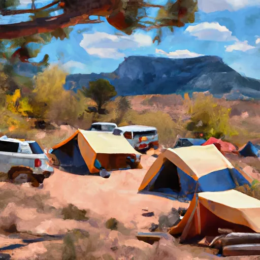
The Timber Camp Campground offers a range of amenities for campers, including picnic tables, fire rings, and vault toilets. This is a first-come, first-serve campground with 9 campsites available. One interesting fact about the area is that it was once a logging camp, hence the name 'Timber Camp'. The best time to visit is between May and October when the temperatures average between 70°F and 85°F during the day and drop to 40°F to 50°F at night, making it the perfect temperature for camping.
Overall, the Timber Camp Camping Area is an excellent option for those seeking a remote and peaceful camping experience in the Coconino National Forest. Its proximity to the Mogollon Rim and Woods Canyon Lake provide ample opportunities for outdoor recreation, and its first-come-first-serve policy allows for a more organic and spontaneous camping experience.
What's on-site at Timber Camp
Key facilities Snoflo tracks for this campground. Confirm with the operator before booking -- amenities can change seasonally.
Plan your trip down to the hour
Same weather feed Snoflo's iOS app uses -- updated continuously from NOAA / yr.no.
Next 5 days, hour by hour
Temperature line with weather symbols on top, snow + rain accumulation as columns, humidity as a dotted line.
5-day forecast table
Every 3 hours, broken out across temperature, snow, rain, humidity, and wind. Each cell is colour-coded relative to the column min/max so trends jump out at a glance.
| Time | Condition | Temp (°F) | Snow (in) | Rain (in) | Humidity (%) | Wind (mps) | Wind dir |
|---|---|---|---|---|---|---|---|
| Loading detailed forecast… | |||||||
15-day temperature & precipitation
Daily temperatures, snow, and rain projected over the next two weeks. Hover any point for the full breakdown.
Other campgrounds in the area
Snoflo-tracked campsites within driving distance of Timber Camp, with reservations status.
| Campground | Reservations | Toilets | View |
|---|---|---|---|
| Timber Camp Recreation Area And Group Campgrounds | ✓ | ✗ | → |
| Jones Water | ✗ | ✗ | → |
| Jones Water Primitive Campground | ✗ | ✗ | → |
| Second Campground | ✗ | ✗ | → |
| Salt Bank Campground | ✗ | ✗ | → |
Nearby streamflow
USGS streamgauges within reach of Timber Camp -- pulled live from the National Water Information System.
| Streamgauge | Discharge | View |
|---|---|---|
| Salt River Near Chrysotile | 112 cfs | → |
| Cibecue Creek Near Chysotile | 39 cfs | → |
| Cherry Creek Near Globe | 5 cfs | → |
| Pinal Creek At Inspiration Dam | 0 cfs | → |
| Salt River Near Roosevelt | 203 cfs | → |
| Black River Near Fort Apache | 33 cfs | → |
Nearby snow depths
NRCS SNOTEL stations within reach of Timber Camp -- relevant when planning a shoulder-season or alpine trip.
| SNOTEL station | Snowpack | 24h Snowfall | View |
|---|---|---|---|
| Workman Creek | 0.0 in | 0.0 in | → |
| Heber | 0.0 in | 0.0 in | → |
| Show Low 4.2 S | 0.0 in | 0.0 in | → |
| Nohrsc Show Low 3.8 W | 0.0 in | 0.0 in | → |
| Nohrsc Pinetop-Lakeside 4.0 Ese | 0.0 in | 0.0 in | → |
| Show Low 6.5 Wnw | 0.0 in | 0.0 in | → |
Plan a longer trip
The closest parks, lakes, boat launches, and paddle runs so a camping night can grow into a full weekend.
Parks
Fishing spots
Points of interest
Paddle runs
- Northeast Boundary Of Salt River Canyon Wildernes To West Boundary Of Fort Apache Indian Reservation
- Upper Salt Daily
- West Boundary Of San Carlos Indian Reservation To Northeast Boundary Of Salt River Canyon Wilderness
- West Boundary Of Fort Apache Indian Reservation To Southwest Boundary Of Salt River Canyon Wilderness
- Southwest Boundary Of Salt River Canyon Wilderness To State Highway 288 Bridge
- Billy Lawrence Creek To North Property Boundary Of Ellison Ranch
Camping essentials & Leave No Trace
- Pack it in, pack it out
- Take all trash, food scraps, and gear back with you to keep campsites clean and protect wildlife.
- Respect wildlife
- Observe animals from a distance, store food securely, and never feed wildlife to maintain natural behavior and safety.
- Know before you go
- Check weather, fire restrictions, trail conditions, and permit requirements to ensure a safe and well-planned trip.
- Minimize campfire impact
- Use established fire rings, keep fires small, fully extinguish them, or opt for a camp stove when fires are restricted.
- Leave what you find
- Preserve natural and cultural features by avoiding removal of plants, rocks, artifacts, or other elements of the environment.
Set push alerts in the Snoflo app
Save Timber Camp as a favorite, set a custom threshold (precipitation, snowpack, freezing temperatures), and the iOS app will push the moment conditions cross.
About Timber Camp
Can I make reservations at Timber Camp?
This campground does not appear to accept reservations -- it's typically first-come, first-served. Arrive early on summer weekends.
How fresh is the weather data on this page?
The hourly forecast updates throughout the day from the NOAA / yr.no public feeds. Streamflow data is pulled live from USGS streamgauges and snowpack from the NRCS SNOTEL network.
What's the best time of year to visit?
Use the 15-day temperature & precipitation outlook on this page to plan -- pick a window with comfortable temperatures and low precipitation. For longer trips, the 5-day hourly meteogram shows snow + rain accumulation hour-by-hour.
How do I get to Timber Camp?
Tap Directions in the hero above to open driving directions in Google Maps, or Open in map to center the Snoflo interactive map on the campground.
Can I get alerts when conditions change?
Yes -- alerts are managed through the Snoflo iOS app. Favorite this campground, set a threshold (temperature, snowpack, precipitation), and you'll get a push the moment it crosses.
Other campgrounds near here
Snoflo-tracked campgrounds within driving distance of Timber Camp.