Turlock Lake State Rec Area Campground
Community Reviews
Been here? Share the conditions.
Reviews, ratings & photos are added in the free Snoflo iOS app — rate a spot, tag the conditions, and your visit is verified by location. Add or manage your reviews from the app.
Turlock Lake State Rec Area
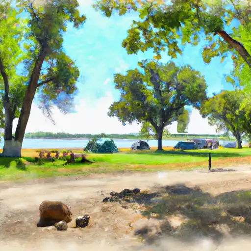
The campground offers a range of amenities, including restrooms, showers, picnic tables, and fire pits. There are 66 campsites available, with both reservation and first-come-first-serve options available.
One interesting fact about the area is that the lake was created by the construction of the Turlock Dam, which was completed in 1955.
The best time of year to visit Turlock Lake State Recreation Area is in the spring and fall when temperatures are milder. The average temperature in the spring months of March to May is around 70°F, while in the fall months of September to November, the temperature averages around 75°F.
Overall, Turlock Lake State Recreation Area is a beautiful and relaxing camping destination that offers a range of activities and amenities for visitors to enjoy.
What's on-site at Turlock Lake State Rec Area
Key facilities Snoflo tracks for this campground. Confirm with the operator before booking -- amenities can change seasonally.
Plan your trip down to the hour
Same weather feed Snoflo's iOS app uses -- updated continuously from NOAA / yr.no.
Next 5 days, hour by hour
Temperature line with weather symbols on top, snow + rain accumulation as columns, humidity as a dotted line.
5-day forecast table
Every 3 hours, broken out across temperature, snow, rain, humidity, and wind. Each cell is colour-coded relative to the column min/max so trends jump out at a glance.
| Time | Condition | Temp (°F) | Snow (in) | Rain (in) | Humidity (%) | Wind (mps) | Wind dir |
|---|---|---|---|---|---|---|---|
| Loading detailed forecast… | |||||||
15-day temperature & precipitation
Daily temperatures, snow, and rain projected over the next two weeks. Hover any point for the full breakdown.
Other campgrounds in the area
Snoflo-tracked campsites within driving distance of Turlock Lake State Rec Area, with reservations status.
| Campground | Reservations | Toilets | View |
|---|---|---|---|
| Modesto Reservoir | ✗ | ✓ | → |
| Blue Oaks - Don Pedro Rec Area | ✗ | ✓ | → |
| Fleming Meadow - Don Pedro Rec Area | ✗ | ✓ | → |
| Horseshoe Road Recreation Area & Campground | ✗ | ✗ | → |
| Barrett Cove Rec Area | ✗ | ✓ | → |
Nearby streamflow
USGS streamgauges within reach of Turlock Lake State Rec Area -- pulled live from the National Water Information System.
| Streamgauge | Discharge | View |
|---|---|---|
| Modesto Cn Nr La Grange Ca | 1,230 cfs | → |
| Tuolumne R Bl Lagrange Dam Nr Lagrange Ca | 193 cfs | → |
| Turlock Cn Nr La Grange Ca | 1,560 cfs | → |
| Tuolumne R A Modesto Ca | 187 cfs | → |
| Black C Nr Copperopolis Ca | · | → |
| Big C Ab Whites Gulch Nr Groveland Ca | · | → |
Nearby snow depths
NRCS SNOTEL stations within reach of Turlock Lake State Rec Area -- relevant when planning a shoulder-season or alpine trip.
| SNOTEL station | Snowpack | 24h Snowfall | View |
|---|---|---|---|
| Knights Ferry 5.2 Wsw | 0.0 in | 0.0 in | → |
| Groveland 2 | 0.0 in | 0.0 in | → |
| Nohrsc Lower Kibbie | 0.0 in | 0.0 in | → |
| Ahwahnee 2.5 Nnw | 0.0 in | 0.0 in | → |
Plan a longer trip
The closest parks, lakes, boat launches, and paddle runs so a camping night can grow into a full weekend.
Parks
- Turlock Lake State Recreation Area
- Big Bear Park
- Beard Park
- Sterling Ranch Park
- Fox Grove Park
- Orange Blossom Recreation Area
Boat launches
- Turlock Lake State Recreation Area (Tuolumne River Access)
- Turlock Lake State Recreation Area
- Basso Bridge
- Modesto Reservoir (Main)
- Modesto Reservoir (West)
- Don Pedro Recreation Area (Blue Oaks)
Fishing spots
Points of interest
- Knight's Ferry Bridge
- Knights Ferry Covered Bridge
- University Art Gallery
- The Cowboy Museum
- Castle Air Museum
- Kc-97l Stratotanker
Paddle runs
- Clavey River From Cottonwood Road To Confluence With Tuolumne
- Confluence With Middle Fork Tuolumne River To Confluence With Tuolumne River
- Confluence With North Fork And Middle Fork Stanislaus To Clark Flat
- Clavey River From 3n01 To Cottonwood Road
- Sandbar To Confluence With North Fork Stanislaus River
Camping essentials & Leave No Trace
- Pack it in, pack it out
- Take all trash, food scraps, and gear back with you to keep campsites clean and protect wildlife.
- Respect wildlife
- Observe animals from a distance, store food securely, and never feed wildlife to maintain natural behavior and safety.
- Know before you go
- Check weather, fire restrictions, trail conditions, and permit requirements to ensure a safe and well-planned trip.
- Minimize campfire impact
- Use established fire rings, keep fires small, fully extinguish them, or opt for a camp stove when fires are restricted.
- Leave what you find
- Preserve natural and cultural features by avoiding removal of plants, rocks, artifacts, or other elements of the environment.
Set push alerts in the Snoflo app
Save Turlock Lake State Rec Area as a favorite, set a custom threshold (precipitation, snowpack, freezing temperatures), and the iOS app will push the moment conditions cross.
About Turlock Lake State Rec Area
Can I make reservations at Turlock Lake State Rec Area?
Yes -- this campground accepts reservations. Snoflo recommends booking early for peak season; check the operator (Recreation.gov / state park system / private operator) for the booking window and cancellation policy.
How fresh is the weather data on this page?
The hourly forecast updates throughout the day from the NOAA / yr.no public feeds. Streamflow data is pulled live from USGS streamgauges and snowpack from the NRCS SNOTEL network.
What's the best time of year to visit?
Use the 15-day temperature & precipitation outlook on this page to plan -- pick a window with comfortable temperatures and low precipitation. For longer trips, the 5-day hourly meteogram shows snow + rain accumulation hour-by-hour.
How do I get to Turlock Lake State Rec Area?
Tap Directions in the hero above to open driving directions in Google Maps, or Open in map to center the Snoflo interactive map on the campground.
Can I get alerts when conditions change?
Yes -- alerts are managed through the Snoflo iOS app. Favorite this campground, set a threshold (temperature, snowpack, precipitation), and you'll get a push the moment it crosses.
Other campgrounds near here
Snoflo-tracked campgrounds within driving distance of Turlock Lake State Rec Area.