The Bank Campground Accessible Campsite B-20 Campground
Community Reviews
Been here? Share the conditions.
Reviews, ratings & photos are added in the free Snoflo iOS app — rate a spot, tag the conditions, and your visit is verified by location. Add or manage your reviews from the app.
The Bank Campground Accessible Campsite B-20
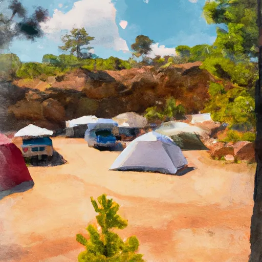
This developed and reservable campground has a fee to stay, but offers plenty of amenities, including potable water, flush toilets, and picnic tables. The accessible campsite B 20 also has a flat gravel pad, paved pathway to the restroom, and accessible fire ring. Additionally, the campground provides easy access to trails and fishing spots in the surrounding area.
Interesting facts about this area include that it is home to some of Colorado's highest peaks, including Mount Elbert, the highest peak in the state, and that the Arkansas River is a popular destination for whitewater rafting and kayaking.
The best time to visit the Bank Campground is during the summer months, from June to September, when temperatures are mild with highs in the mid-70s to low 80s and lows in the 40s to low 50s. Visitors should note that the area can experience occasional thunderstorms during the summer months, and nighttime temperatures can drop significantly.
What's on-site at The Bank Campground Accessible Campsite B-20
Key facilities Snoflo tracks for this campground. Confirm with the operator before booking -- amenities can change seasonally.
Plan your trip down to the hour
Same weather feed Snoflo's iOS app uses -- updated continuously from NOAA / yr.no.
Next 5 days, hour by hour
Temperature line with weather symbols on top, snow + rain accumulation as columns, humidity as a dotted line.
5-day forecast table
Every 3 hours, broken out across temperature, snow, rain, humidity, and wind. Each cell is colour-coded relative to the column min/max so trends jump out at a glance.
| Time | Condition | Temp (°F) | Snow (in) | Rain (in) | Humidity (%) | Wind (mps) | Wind dir |
|---|---|---|---|---|---|---|---|
| Loading detailed forecast… | |||||||
15-day temperature & precipitation
Daily temperatures, snow, and rain projected over the next two weeks. Hover any point for the full breakdown.
Other campgrounds in the area
Snoflo-tracked campsites within driving distance of The Bank Campground Accessible Campsite B-20, with reservations status.
| Campground | Reservations | Toilets | View |
|---|---|---|---|
| The Bank Campground Accessible Campsite B-18 | ✗ | ✗ | → |
| The Bank Campground Accessible Campsite B-21 | ✗ | ✗ | → |
| The Bank Campground Accessible Campsite B-19 | ✗ | ✗ | → |
| The Bank Campground Accessible Campsite B-22 | ✗ | ✗ | → |
| The Bank Campground Accessible Campsite B-17 | ✗ | ✗ | → |
Nearby streamflow
USGS streamgauges within reach of The Bank Campground Accessible Campsite B-20 -- pulled live from the National Water Information System.
| Streamgauge | Discharge | View |
|---|---|---|
| Fourmile Creek Below Cripple Creek Near Victor | 4 cfs | → |
| Beaver Cr Abv Upper Beaver Cemetery Nr Penrose | 4 cfs | → |
| Arkansas River At Parkdale | 203 cfs | → |
| Arkansas River At Canon City | 147 cfs | → |
| Beaver Creek Above Highway 115 Near Penrose | · | → |
| Turkey Creek Near Fountain Colo | 2 cfs | → |
Nearby snow depths
NRCS SNOTEL stations within reach of The Bank Campground Accessible Campsite B-20 -- relevant when planning a shoulder-season or alpine trip.
| SNOTEL station | Snowpack | 24h Snowfall | View |
|---|---|---|---|
| Guffey 9se | 0.0 in | 0.0 in | → |
| Cripple Creek | 36.0 in | 0.0 in | → |
| Canon City | 0.0 in | 0.0 in | → |
| Cripple Creek 5.1 Nw | 2.0 in | 1.9 in | → |
| Nohrsc Divide 5.2 Ssw | 0.0 in | 0.0 in | → |
| Nohrsc Glen Cove | 1.0 in | 0.0 in | → |
Plan a longer trip
The closest parks, lakes, boat launches, and paddle runs so a camping night can grow into a full weekend.
Parks
- Royal Gorge Park
- Mueller State Park
- Florissant Fossil Beds National Monument
- Pike National Forest
- Bear Creek Canyon
- Bear Creek Regional Park
Boat launches
- Skagway Road Teller County
- Ahra - Parkdale Rec Site
- Arkansas Headwaters Recreation Area
- Brush Hollow State Wildlife Area
- Ahra - Spikebuck Rec Site
Fishing spots
- Skaguay Reservoir
- Brush Hollow Reservoir
- Mason Reservoir
- Mcreynolds Reservoir
- Rosemont Reservoir
- North Catamount Reservoir
Camping essentials & Leave No Trace
- Pack it in, pack it out
- Take all trash, food scraps, and gear back with you to keep campsites clean and protect wildlife.
- Respect wildlife
- Observe animals from a distance, store food securely, and never feed wildlife to maintain natural behavior and safety.
- Know before you go
- Check weather, fire restrictions, trail conditions, and permit requirements to ensure a safe and well-planned trip.
- Minimize campfire impact
- Use established fire rings, keep fires small, fully extinguish them, or opt for a camp stove when fires are restricted.
- Leave what you find
- Preserve natural and cultural features by avoiding removal of plants, rocks, artifacts, or other elements of the environment.
Set push alerts in the Snoflo app
Save The Bank Campground Accessible Campsite B-20 as a favorite, set a custom threshold (precipitation, snowpack, freezing temperatures), and the iOS app will push the moment conditions cross.
About The Bank Campground Accessible Campsite B-20
Can I make reservations at The Bank Campground Accessible Campsite B-20?
This campground does not appear to accept reservations -- it's typically first-come, first-served. Arrive early on summer weekends.
How fresh is the weather data on this page?
The hourly forecast updates throughout the day from the NOAA / yr.no public feeds. Streamflow data is pulled live from USGS streamgauges and snowpack from the NRCS SNOTEL network.
What's the best time of year to visit?
Use the 15-day temperature & precipitation outlook on this page to plan -- pick a window with comfortable temperatures and low precipitation. For longer trips, the 5-day hourly meteogram shows snow + rain accumulation hour-by-hour.
How do I get to The Bank Campground Accessible Campsite B-20?
Tap Directions in the hero above to open driving directions in Google Maps, or Open in map to center the Snoflo interactive map on the campground.
Can I get alerts when conditions change?
Yes -- alerts are managed through the Snoflo iOS app. Favorite this campground, set a threshold (temperature, snowpack, precipitation), and you'll get a push the moment it crosses.
Other campgrounds near here
Snoflo-tracked campgrounds within driving distance of The Bank Campground Accessible Campsite B-20.