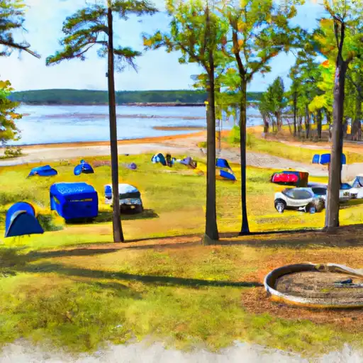
Degray Lake State Park Campground
Community Reviews
Been here? Share the conditions.
Reviews, ratings & photos are added in the free Snoflo iOS app — rate a spot, tag the conditions, and your visit is verified by location. Add or manage your reviews from the app.
Degray Lake State Park
Reservations are accepted at Degray Lake State Park, allowing visitors to secure their preferred campsites in advance. It is recommended to make reservations, especially during peak seasons, to ensure availability. The best time to visit the camping area is during the spring and fall when the weather is mild, and the scenic beauty of the park is at its peak. Summer is also a popular time, as visitors can enjoy swimming, fishing, and boating in the lake.
While camping at Degray Lake State Park, campers can explore various points of interest. The park offers several hiking trails, including the 1.5-mile Island Trail, which takes visitors through the forested areas surrounding the lake. Wildlife enthusiasts can spot a variety of animals, such as deer, raccoons, and a variety of bird species. Visitors should be cautious and mindful of their surroundings, as black bears have been spotted in the park. Proper food storage and adherence to park guidelines are essential for a safe camping experience. With its amenities, beautiful surroundings, and recreational activities, Degray Lake State Park camping area is a fantastic destination for nature lovers and outdoor enthusiasts.
What's on-site at Degray Lake State Park
Key facilities Snoflo tracks for this campground. Confirm with the operator before booking -- amenities can change seasonally.
Plan your trip down to the hour
Same weather feed Snoflo's iOS app uses -- updated continuously from NOAA / yr.no.
Next 5 days, hour by hour
Temperature line with weather symbols on top, snow + rain accumulation as columns, humidity as a dotted line.
5-day forecast table
Every 3 hours, broken out across temperature, snow, rain, humidity, and wind. Each cell is colour-coded relative to the column min/max so trends jump out at a glance.
| Time | Condition | Temp (°F) | Snow (in) | Rain (in) | Humidity (%) | Wind (mps) | Wind dir |
|---|---|---|---|---|---|---|---|
| Loading detailed forecast… | |||||||
15-day temperature & precipitation
Daily temperatures, snow, and rain projected over the next two weeks. Hover any point for the full breakdown.
Other campgrounds in the area
Snoflo-tracked campsites within driving distance of Degray Lake State Park, with reservations status.
| Campground | Reservations | Toilets | View |
|---|---|---|---|
| Iron Mountain - De Gray Lake | ✓ | ✓ | → |
| Edgewood - De Gray Lake | ✓ | ✓ | → |
| Caddo Drive - De Gray Lake | ✓ | ✓ | → |
| Arlie Moore - De Gray Lake | ✓ | ✓ | → |
| Ozan Point - De Gray Lake | ✗ | ✓ | → |
Nearby streamflow
USGS streamgauges within reach of Degray Lake State Park -- pulled live from the National Water Information System.
| Streamgauge | Discharge | View |
|---|---|---|
| Ouachita River At Remmel Dam Above Jones Mill | 289 cfs | → |
| West Fork Hot Springs Creek At Hot Springs | · | → |
| Antoine River At Antoine | 86 cfs | → |
| Caddo River Near Caddo Gap | 45 cfs | → |
| Saline River At Benton | 65 cfs | → |
| Alum Fork Saline River Near Reform | 1 cfs | → |
Plan a longer trip
The closest parks, lakes, boat launches, and paddle runs so a camping night can grow into a full weekend.
Parks
- Degray Lake Resort State Park
- Friendship City Park
- Arkadelphia Central Park
- Terre Noire Natural Area Wildlife Management Area
- Electric Island Wildlife Management Area
- Hill Wheatley Park
Boat launches
- Campground Road
- Small Dike Road
- Iron Mountain Ramp Road
- Iron Mountain Marina
- Caddo Drive Campground
- Spillway Dam Recreation Area
Fishing spots
Camping essentials & Leave No Trace
- Pack it in, pack it out
- Take all trash, food scraps, and gear back with you to keep campsites clean and protect wildlife.
- Respect wildlife
- Observe animals from a distance, store food securely, and never feed wildlife to maintain natural behavior and safety.
- Know before you go
- Check weather, fire restrictions, trail conditions, and permit requirements to ensure a safe and well-planned trip.
- Minimize campfire impact
- Use established fire rings, keep fires small, fully extinguish them, or opt for a camp stove when fires are restricted.
- Leave what you find
- Preserve natural and cultural features by avoiding removal of plants, rocks, artifacts, or other elements of the environment.
Set push alerts in the Snoflo app
Save Degray Lake State Park as a favorite, set a custom threshold (precipitation, snowpack, freezing temperatures), and the iOS app will push the moment conditions cross.
About Degray Lake State Park
Can I make reservations at Degray Lake State Park?
Yes -- this campground accepts reservations. Snoflo recommends booking early for peak season; check the operator (Recreation.gov / state park system / private operator) for the booking window and cancellation policy.
How fresh is the weather data on this page?
The hourly forecast updates throughout the day from the NOAA / yr.no public feeds. Streamflow data is pulled live from USGS streamgauges and snowpack from the NRCS SNOTEL network.
What's the best time of year to visit?
Use the 15-day temperature & precipitation outlook on this page to plan -- pick a window with comfortable temperatures and low precipitation. For longer trips, the 5-day hourly meteogram shows snow + rain accumulation hour-by-hour.
How do I get to Degray Lake State Park?
Tap Directions in the hero above to open driving directions in Google Maps, or Open in map to center the Snoflo interactive map on the campground.
Can I get alerts when conditions change?
Yes -- alerts are managed through the Snoflo iOS app. Favorite this campground, set a threshold (temperature, snowpack, precipitation), and you'll get a push the moment it crosses.
Other campgrounds near here
Snoflo-tracked campgrounds within driving distance of Degray Lake State Park.