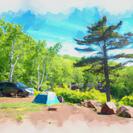
Tettegouche State Park Campground
Community Reviews
Been here? Share the conditions.
Reviews, ratings & photos are added in the free Snoflo iOS app — rate a spot, tag the conditions, and your visit is verified by location. Add or manage your reviews from the app.
Tettegouche State Park
Nearby points of interest include Split Rock Lighthouse, Gooseberry Falls State Park, and the Superior Hiking Trail. Within the park, visitors can enjoy rock climbing, bird watching, and beachcombing.
The campground amenities include showers, a dump station, and firewood for sale. The campsites are available on a reservation or first-come-first-serve basis, and there are 76 sites in total. An interesting fact about the area is that the park is home to the tallest waterfall in Minnesota, High Falls, which drops 60 feet into the Baptism River.
The best time to visit Tettegouche State Park is in the summer months, from June to August, with average temperatures ranging from 60 to 75 degrees Fahrenheit. However, the fall offers stunning views of the changing leaves and the winter months allow for cross-country skiing and snowshoeing.
What's on-site at Tettegouche State Park
Key facilities Snoflo tracks for this campground. Confirm with the operator before booking -- amenities can change seasonally.
Plan your trip down to the hour
Same weather feed Snoflo's iOS app uses -- updated continuously from NOAA / yr.no.
Next 5 days, hour by hour
Temperature line with weather symbols on top, snow + rain accumulation as columns, humidity as a dotted line.
5-day forecast table
Every 3 hours, broken out across temperature, snow, rain, humidity, and wind. Each cell is colour-coded relative to the column min/max so trends jump out at a glance.
| Time | Condition | Temp (°F) | Snow (in) | Rain (in) | Humidity (%) | Wind (mps) | Wind dir |
|---|---|---|---|---|---|---|---|
| Loading detailed forecast… | |||||||
15-day temperature & precipitation
Daily temperatures, snow, and rain projected over the next two weeks. Hover any point for the full breakdown.
Other campgrounds in the area
Snoflo-tracked campsites within driving distance of Tettegouche State Park, with reservations status.
| Campground | Reservations | Toilets | View |
|---|---|---|---|
| Tettegouche Baptism River Campground | ✗ | ✗ | → |
| Baptism River Watercraft Campsite | ✗ | ✗ | → |
| Tettegouche State Park Campground | ✗ | ✓ | → |
| Palisade Coast Watercraft Campsite | ✗ | ✗ | → |
| Eckbeck Campground - Finland State Forest | ✗ | ✗ | → |
Nearby streamflow
USGS streamgauges within reach of Tettegouche State Park -- pulled live from the National Water Information System.
| Streamgauge | Discharge | View |
|---|---|---|
| Knife River Near Two Harbors | 3 cfs | → |
| South Kawishiwi River Near Ely | 85 cfs | → |
| Kawishiwi River Near Ely | 54 cfs | → |
| South Kawishiwi R Abv White Iron Lake Nr Ely | 124 cfs | → |
| Whittlesey Creek Near Ashland | 21 cfs | → |
| Basswood River Near Winton | 437 cfs | → |
Nearby snow depths
NRCS SNOTEL stations within reach of Tettegouche State Park -- relevant when planning a shoulder-season or alpine trip.
| SNOTEL station | Snowpack | 24h Snowfall | View |
|---|---|---|---|
| Wolf Ridge Environ Learning Center | 0.0 in | 0.0 in | → |
| Tofte 0.9 Sw | 0.0 in | 0.0 in | → |
| Tofte 0.8 Wsw | 6.0 in | 0.0 in | → |
| Isabella 14w | 19.0 in | 0.0 in | → |
| Two Harbors | 0.0 in | 0.0 in | → |
| Nohrsc Tofte 4.9 Ne | 0.0 in | 0.0 in | → |
Plan a longer trip
The closest parks, lakes, boat launches, and paddle runs so a camping night can grow into a full weekend.
Parks
- Tettgouche State Park
- George H. Crosby Manitou State Park
- Caribou Falls State Wayside
- Split Rock Lighthouse State Park
- Gooseberry Falls State Park
- Temperance River State Park
Boat launches
- Lax Lake Public Water Access
- Silver Bay Safe Harbor
- Gitchi-Gami State Trail Lake County
- Lake County
- Taconite Harbor
- Dumbbell Lake
Fishing spots
Camping essentials & Leave No Trace
- Pack it in, pack it out
- Take all trash, food scraps, and gear back with you to keep campsites clean and protect wildlife.
- Respect wildlife
- Observe animals from a distance, store food securely, and never feed wildlife to maintain natural behavior and safety.
- Know before you go
- Check weather, fire restrictions, trail conditions, and permit requirements to ensure a safe and well-planned trip.
- Minimize campfire impact
- Use established fire rings, keep fires small, fully extinguish them, or opt for a camp stove when fires are restricted.
- Leave what you find
- Preserve natural and cultural features by avoiding removal of plants, rocks, artifacts, or other elements of the environment.
Set push alerts in the Snoflo app
Save Tettegouche State Park as a favorite, set a custom threshold (precipitation, snowpack, freezing temperatures), and the iOS app will push the moment conditions cross.
About Tettegouche State Park
Can I make reservations at Tettegouche State Park?
Yes -- this campground accepts reservations. Snoflo recommends booking early for peak season; check the operator (Recreation.gov / state park system / private operator) for the booking window and cancellation policy.
How fresh is the weather data on this page?
The hourly forecast updates throughout the day from the NOAA / yr.no public feeds. Streamflow data is pulled live from USGS streamgauges and snowpack from the NRCS SNOTEL network.
What's the best time of year to visit?
Use the 15-day temperature & precipitation outlook on this page to plan -- pick a window with comfortable temperatures and low precipitation. For longer trips, the 5-day hourly meteogram shows snow + rain accumulation hour-by-hour.
How do I get to Tettegouche State Park?
Tap Directions in the hero above to open driving directions in Google Maps, or Open in map to center the Snoflo interactive map on the campground.
Can I get alerts when conditions change?
Yes -- alerts are managed through the Snoflo iOS app. Favorite this campground, set a threshold (temperature, snowpack, precipitation), and you'll get a push the moment it crosses.
Other campgrounds near here
Snoflo-tracked campgrounds within driving distance of Tettegouche State Park.