High Bridge - State Forest Campground
Community Reviews
Been here? Share the conditions.
Reviews, ratings & photos are added in the free Snoflo iOS app — rate a spot, tag the conditions, and your visit is verified by location. Add or manage your reviews from the app.
High Bridge - State Forest
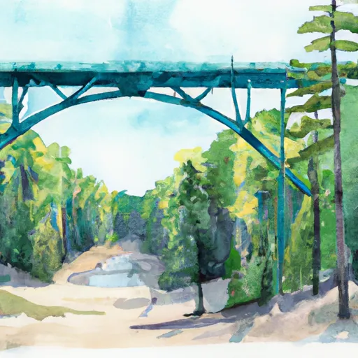
The best time to visit High Bridge - State Forest camping area is during the warmer months, typically from late spring to early fall. This allows campers to fully enjoy the outdoor activities and natural beauty that the area has to offer. The campground is surrounded by scenic forests and features the stunning High Bridge, which is an iconic attraction in the area. It is important for campers to be cautious and aware of their surroundings while exploring the camping area. The nearby river can be dangerous, especially during periods of high water or heavy rainfall, so it is advised to avoid swimming or boating in these conditions. Overall, High Bridge - State Forest camping area provides a rustic camping experience amidst the tranquil wilderness of Michigan.
What's on-site at High Bridge - State Forest
Key facilities Snoflo tracks for this campground. Confirm with the operator before booking -- amenities can change seasonally.
Plan your trip down to the hour
Same weather feed Snoflo's iOS app uses -- updated continuously from NOAA / yr.no.
Next 5 days, hour by hour
Temperature line with weather symbols on top, snow + rain accumulation as columns, humidity as a dotted line.
5-day forecast table
Every 3 hours, broken out across temperature, snow, rain, humidity, and wind. Each cell is colour-coded relative to the column min/max so trends jump out at a glance.
| Time | Condition | Temp (°F) | Snow (in) | Rain (in) | Humidity (%) | Wind (mps) | Wind dir |
|---|---|---|---|---|---|---|---|
| Loading detailed forecast… | |||||||
15-day temperature & precipitation
Daily temperatures, snow, and rain projected over the next two weeks. Hover any point for the full breakdown.
Other campgrounds in the area
Snoflo-tracked campsites within driving distance of High Bridge - State Forest, with reservations status.
| Campground | Reservations | Toilets | View |
|---|---|---|---|
| High Bridge State Forest Campground | ✗ | ✗ | → |
| Headquarters Lake - State Forest | ✗ | ✗ | → |
| Perch Lake - State Forest | ✗ | ✗ | → |
| Perch Lake State Forest Campground | ✗ | ✗ | → |
| Holland Lake State Forest Campground | ✗ | ✗ | → |
Nearby streamflow
USGS streamgauges within reach of High Bridge - State Forest -- pulled live from the National Water Information System.
| Streamgauge | Discharge | View |
|---|---|---|
| Tahquamenon River Near Paradise | 619 cfs | → |
| Black River Near Garnet | 9 cfs | → |
| Manistique River Near Manistique | 990 cfs | → |
Nearby snow depths
NRCS SNOTEL stations within reach of High Bridge - State Forest -- relevant when planning a shoulder-season or alpine trip.
| SNOTEL station | Snowpack | 24h Snowfall | View |
|---|---|---|---|
| Mcmillan 7.4 N | 0.0 in | 2.1 in | → |
| Newberry-Luce County Road Commission | 0.0 in | 0.0 in | → |
| Engadine Mdot | 0.0 in | 0.0 in | → |
Plan a longer trip
The closest parks, lakes, boat launches, and paddle runs so a camping night can grow into a full weekend.
Parks
- Muskallonge Lake State Park
- Tahquamenon Falls State Park
- Wilderness Area Seney
- Wilderness Beaver Basin
Boat launches
- County Road 410 East Mcmillan Township
- Muskallonge Lake State Park Mcmillan Township
- Grand Marais Road Mcmillan Township
- Blind Sucker State Forest Campground
- Pike Lake
- Ricketes Road Mcmillan Township
Fishing spots
Camping essentials & Leave No Trace
- Pack it in, pack it out
- Take all trash, food scraps, and gear back with you to keep campsites clean and protect wildlife.
- Respect wildlife
- Observe animals from a distance, store food securely, and never feed wildlife to maintain natural behavior and safety.
- Know before you go
- Check weather, fire restrictions, trail conditions, and permit requirements to ensure a safe and well-planned trip.
- Minimize campfire impact
- Use established fire rings, keep fires small, fully extinguish them, or opt for a camp stove when fires are restricted.
- Leave what you find
- Preserve natural and cultural features by avoiding removal of plants, rocks, artifacts, or other elements of the environment.
Set push alerts in the Snoflo app
Save High Bridge - State Forest as a favorite, set a custom threshold (precipitation, snowpack, freezing temperatures), and the iOS app will push the moment conditions cross.
About High Bridge - State Forest
Can I make reservations at High Bridge - State Forest?
This campground does not appear to accept reservations -- it's typically first-come, first-served. Arrive early on summer weekends.
How fresh is the weather data on this page?
The hourly forecast updates throughout the day from the NOAA / yr.no public feeds. Streamflow data is pulled live from USGS streamgauges and snowpack from the NRCS SNOTEL network.
What's the best time of year to visit?
Use the 15-day temperature & precipitation outlook on this page to plan -- pick a window with comfortable temperatures and low precipitation. For longer trips, the 5-day hourly meteogram shows snow + rain accumulation hour-by-hour.
How do I get to High Bridge - State Forest?
Tap Directions in the hero above to open driving directions in Google Maps, or Open in map to center the Snoflo interactive map on the campground.
Can I get alerts when conditions change?
Yes -- alerts are managed through the Snoflo iOS app. Favorite this campground, set a threshold (temperature, snowpack, precipitation), and you'll get a push the moment it crosses.
Other campgrounds near here
Snoflo-tracked campgrounds within driving distance of High Bridge - State Forest.