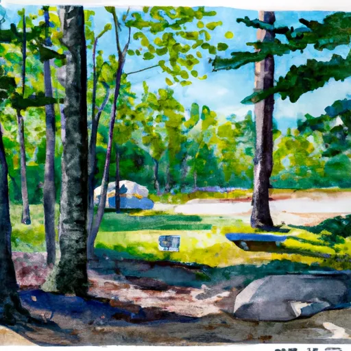
Natalie - State Forest Campground
Community Reviews
Been here? Share the conditions.
Reviews, ratings & photos are added in the free Snoflo iOS app — rate a spot, tag the conditions, and your visit is verified by location. Add or manage your reviews from the app.
Natalie - State Forest
Reservations are not accepted at Natalie - State Forest camping area, and campsites are available on a first-come, first-served basis. Therefore, it is advisable to arrive early, especially during peak seasons, to secure a spot. The best time to visit this campground is during the summer months when the weather is pleasant for outdoor activities. However, it is recommended to check for any closures or restrictions due to weather conditions before planning your trip.
While camping at Natalie - State Forest, there are a few things to be mindful of. The campground is located in a forested area, so campers should be cautious of wildlife such as bears and raccoons. It is important to properly store food and dispose of trash to avoid attracting these animals. Additionally, campers should be prepared for mosquitoes and other insects, especially during the warmer months. Wearing insect repellent and bringing citronella candles or mosquito nets can make your camping experience more enjoyable. Overall, Natalie - State Forest camping area offers a peaceful and scenic environment for nature lovers to enjoy the great outdoors.
What's on-site at Natalie - State Forest
Key facilities Snoflo tracks for this campground. Confirm with the operator before booking -- amenities can change seasonally.
Plan your trip down to the hour
Same weather feed Snoflo's iOS app uses -- updated continuously from NOAA / yr.no.
Next 5 days, hour by hour
Temperature line with weather symbols on top, snow + rain accumulation as columns, humidity as a dotted line.
5-day forecast table
Every 3 hours, broken out across temperature, snow, rain, humidity, and wind. Each cell is colour-coded relative to the column min/max so trends jump out at a glance.
| Time | Condition | Temp (°F) | Snow (in) | Rain (in) | Humidity (%) | Wind (mps) | Wind dir |
|---|---|---|---|---|---|---|---|
| Loading detailed forecast… | |||||||
15-day temperature & precipitation
Daily temperatures, snow, and rain projected over the next two weeks. Hover any point for the full breakdown.
Other campgrounds in the area
Snoflo-tracked campsites within driving distance of Natalie - State Forest, with reservations status.
| Campground | Reservations | Toilets | View |
|---|---|---|---|
| Natalie State Forest Campground | ✗ | ✗ | → |
| Larry's Rv Park & Cabins | ✗ | ✗ | → |
| Bass Lake State Forest Campground (Luce) | ✗ | ✗ | → |
| South Manistique Lake State Forest Campground | ✗ | ✗ | → |
| Sherman's Resort | ✗ | ✗ | → |
Nearby streamflow
USGS streamgauges within reach of Natalie - State Forest -- pulled live from the National Water Information System.
| Streamgauge | Discharge | View |
|---|---|---|
| Black River Near Garnet | 9 cfs | → |
| Tahquamenon River Near Paradise | 619 cfs | → |
| Manistique River Near Manistique | 990 cfs | → |
| Au Train River At Forest Lake | 137 cfs | → |
| Sturgeon River Near Nahma Junction | 108 cfs | → |
Nearby snow depths
NRCS SNOTEL stations within reach of Natalie - State Forest -- relevant when planning a shoulder-season or alpine trip.
| SNOTEL station | Snowpack | 24h Snowfall | View |
|---|---|---|---|
| Newberry-Luce County Road Commission | 0.0 in | 0.0 in | → |
| Mcmillan 7.4 N | 0.0 in | 2.1 in | → |
| Engadine Mdot | 0.0 in | 0.0 in | → |
| Manistique 2.7 Nw | 0.0 in | 0.0 in | → |
| Manistique Wwtp | 0.0 in | 0.0 in | → |
Plan a longer trip
The closest parks, lakes, boat launches, and paddle runs so a camping night can grow into a full weekend.
Parks
- Muskallonge Lake State Park
- Wilderness Area Seney
- Seney National Wildlife Refuge
- Tahquamenon Falls State Park
- Trout Lake Park
Boat launches
- County Highway 434 Dollarville
- Dollarville Road Dollarville
- Kaks Lake Road Pentland Township
- M 28 Pentland Township
- M 28 Lakefield Township
Fishing spots
- Tahquamenon River (Dollarville Dam)
- Manistique Lake
- Muskallonge Lake
- Brevoort Lake
- Quarry Lake
- Indian Lake
Points of interest
- Tahquamenon Logging Museum
- Oswald's Bear Ranch
- Garlyn Zoo
- Grand Marais Harbor Of Refuge Inner Light
- Maritime
- Gitche Gumee Museum
Paddle runs
- East Branch From Western Forest Boundary (Sec 19, T46n, R6w) To Confluence With Mainstem
- Source In Sec 21, T47n, R12w To Mouth At Whitefish Bay
- Origin At Confluence Of Outlets Of Frenchman Lake And Carp Lake (Sec 26, T44n, R6w) To West Section Line Of Sec 30, T43n, R5w
- Section 17, T48n, R17w (Boundary Of Pictured Rocks National Lakeshore Lands) To Mouth At Lake Superior
Camping essentials & Leave No Trace
- Pack it in, pack it out
- Take all trash, food scraps, and gear back with you to keep campsites clean and protect wildlife.
- Respect wildlife
- Observe animals from a distance, store food securely, and never feed wildlife to maintain natural behavior and safety.
- Know before you go
- Check weather, fire restrictions, trail conditions, and permit requirements to ensure a safe and well-planned trip.
- Minimize campfire impact
- Use established fire rings, keep fires small, fully extinguish them, or opt for a camp stove when fires are restricted.
- Leave what you find
- Preserve natural and cultural features by avoiding removal of plants, rocks, artifacts, or other elements of the environment.
Set push alerts in the Snoflo app
Save Natalie - State Forest as a favorite, set a custom threshold (precipitation, snowpack, freezing temperatures), and the iOS app will push the moment conditions cross.
About Natalie - State Forest
Can I make reservations at Natalie - State Forest?
This campground does not appear to accept reservations -- it's typically first-come, first-served. Arrive early on summer weekends.
How fresh is the weather data on this page?
The hourly forecast updates throughout the day from the NOAA / yr.no public feeds. Streamflow data is pulled live from USGS streamgauges and snowpack from the NRCS SNOTEL network.
What's the best time of year to visit?
Use the 15-day temperature & precipitation outlook on this page to plan -- pick a window with comfortable temperatures and low precipitation. For longer trips, the 5-day hourly meteogram shows snow + rain accumulation hour-by-hour.
How do I get to Natalie - State Forest?
Tap Directions in the hero above to open driving directions in Google Maps, or Open in map to center the Snoflo interactive map on the campground.
Can I get alerts when conditions change?
Yes -- alerts are managed through the Snoflo iOS app. Favorite this campground, set a threshold (temperature, snowpack, precipitation), and you'll get a push the moment it crosses.
Other campgrounds near here
Snoflo-tracked campgrounds within driving distance of Natalie - State Forest.