Alley Spring - Ozark National Scenic River Campground
Community Reviews
Been here? Share the conditions.
Reviews, ratings & photos are added in the free Snoflo iOS app — rate a spot, tag the conditions, and your visit is verified by location. Add or manage your reviews from the app.
Alley Spring - Ozark National Scenic River
Reservations are accepted at Alley Spring - Ozark National Scenic River camping area, ensuring that you secure a spot during peak season. The best time to visit this campground is during spring and fall when the weather is pleasant, and the foliage is at its most vibrant. During these seasons, you can enjoy activities like hiking, fishing, canoeing, and wildlife viewing.
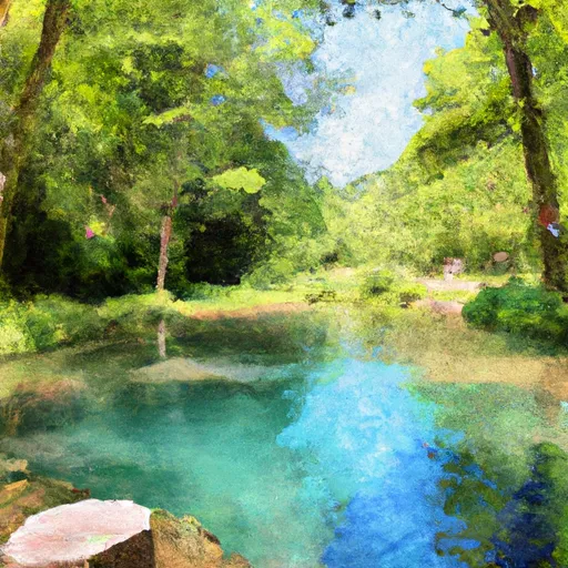
While camping at Alley Spring, there are a few specific items of interest to explore. The campground is situated near the stunning Alley Spring and Mill, which offers breathtaking views and a glimpse into the area's history. There are also several hiking trails nearby, providing opportunities for scenic walks amidst the natural beauty of the Ozarks. However, campers should be cautious of their surroundings as this is a wild area and encounters with snakes and other wildlife are possible. It is advisable to bring insect repellent and take necessary precautions to prevent any inconvenience.
In summary, Alley Spring - Ozark National Scenic River camping area in Missouri is a well-equipped campground with amenities such as picnic tables, fire rings, restrooms, and drinking water. Reservations are accepted, and the best time to visit is during spring and fall. Visitors can explore the nearby Alley Spring and Mill, hike the surrounding trails, and enjoy various outdoor activities. However, campers should remain cautious of wildlife encounters and come prepared with insect repellent.
What's on-site at Alley Spring - Ozark National Scenic River
Key facilities Snoflo tracks for this campground. Confirm with the operator before booking -- amenities can change seasonally.
Plan your trip down to the hour
Same weather feed Snoflo's iOS app uses -- updated continuously from NOAA / yr.no.
Next 5 days, hour by hour
Temperature line with weather symbols on top, snow + rain accumulation as columns, humidity as a dotted line.
5-day forecast table
Every 3 hours, broken out across temperature, snow, rain, humidity, and wind. Each cell is colour-coded relative to the column min/max so trends jump out at a glance.
| Time | Condition | Temp (°F) | Snow (in) | Rain (in) | Humidity (%) | Wind (mps) | Wind dir |
|---|---|---|---|---|---|---|---|
| Loading detailed forecast… | |||||||
15-day temperature & precipitation
Daily temperatures, snow, and rain projected over the next two weeks. Hover any point for the full breakdown.
Other campgrounds in the area
Snoflo-tracked campsites within driving distance of Alley Spring - Ozark National Scenic River, with reservations status.
| Campground | Reservations | Toilets | View |
|---|---|---|---|
| Walk In Sites | ✗ | ✗ | → |
| Alley Spring | ✗ | ✗ | → |
| Bay Creek | ✗ | ✗ | → |
| Shawnee Creek | ✗ | ✗ | → |
| Rymer Spring | ✗ | ✗ | → |
Nearby streamflow
USGS streamgauges within reach of Alley Spring - Ozark National Scenic River -- pulled live from the National Water Information System.
| Streamgauge | Discharge | View |
|---|---|---|
| Jacks Fork At Alley Spring | 123 cfs | → |
| Jacks Fork At Eminence | 199 cfs | → |
| Jacks Fork Near Mountain View | 101 cfs | → |
| Current River Above Akers | 212 cfs | → |
| Current River At Van Buren | 1,010 cfs | → |
| Logan Creek At Ellington | 7 cfs | → |
Nearby snow depths
NRCS SNOTEL stations within reach of Alley Spring - Ozark National Scenic River -- relevant when planning a shoulder-season or alpine trip.
| SNOTEL station | Snowpack | 24h Snowfall | View |
|---|---|---|---|
| Clearwater Dam - Black Rvr | 0.0 in | 0.0 in | → |
Plan a longer trip
The closest parks, lakes, boat launches, and paddle runs so a camping night can grow into a full weekend.
Parks
- Alley Spring Natural Area
- Alley Spring State Forest
- Conservation Area Angeline
- Sunklands Conservation Area
- Round Spring State Park
- Sunklands Natural Area
Boat launches
- State Highway 106 Shannon County
- Eminence (Joshua T. Chilton Mem Access)
- Two Rivers Access (Ozark National Scenic Riverways)
- Shannon County
- State Highway B Shannon County
- Sims Valley Community Lake
Points of interest
- Alley General Store
- Alley Mill
- Round Spring Visitor Center
- Walter Klepzig Mill And Farm
- Welch Spring
- Ozark Nsr Headquarters
Paddle runs
- Confluence With Alley Spring (Branch) To Confluence With Current River (Does Not Include River Segment In Gap Between Parkland Units)
- Western Edge Of Ozark National Scenic Riverways To Confluence With Alley Spring (Branch)
- The Most Upstream Portion Of Ozark National Scenic Riverways To The Most Downstream Portion Of Ozark National Scenic Riverways
- Markam Spring Recreation Area To Nf Boundary
Camping essentials & Leave No Trace
- Pack it in, pack it out
- Take all trash, food scraps, and gear back with you to keep campsites clean and protect wildlife.
- Respect wildlife
- Observe animals from a distance, store food securely, and never feed wildlife to maintain natural behavior and safety.
- Know before you go
- Check weather, fire restrictions, trail conditions, and permit requirements to ensure a safe and well-planned trip.
- Minimize campfire impact
- Use established fire rings, keep fires small, fully extinguish them, or opt for a camp stove when fires are restricted.
- Leave what you find
- Preserve natural and cultural features by avoiding removal of plants, rocks, artifacts, or other elements of the environment.
Set push alerts in the Snoflo app
Save Alley Spring - Ozark National Scenic River as a favorite, set a custom threshold (precipitation, snowpack, freezing temperatures), and the iOS app will push the moment conditions cross.
About Alley Spring - Ozark National Scenic River
Can I make reservations at Alley Spring - Ozark National Scenic River?
Yes -- this campground accepts reservations. Snoflo recommends booking early for peak season; check the operator (Recreation.gov / state park system / private operator) for the booking window and cancellation policy.
How fresh is the weather data on this page?
The hourly forecast updates throughout the day from the NOAA / yr.no public feeds. Streamflow data is pulled live from USGS streamgauges and snowpack from the NRCS SNOTEL network.
What's the best time of year to visit?
Use the 15-day temperature & precipitation outlook on this page to plan -- pick a window with comfortable temperatures and low precipitation. For longer trips, the 5-day hourly meteogram shows snow + rain accumulation hour-by-hour.
How do I get to Alley Spring - Ozark National Scenic River?
Tap Directions in the hero above to open driving directions in Google Maps, or Open in map to center the Snoflo interactive map on the campground.
Can I get alerts when conditions change?
Yes -- alerts are managed through the Snoflo iOS app. Favorite this campground, set a threshold (temperature, snowpack, precipitation), and you'll get a push the moment it crosses.
Other campgrounds near here
Snoflo-tracked campgrounds within driving distance of Alley Spring - Ozark National Scenic River.