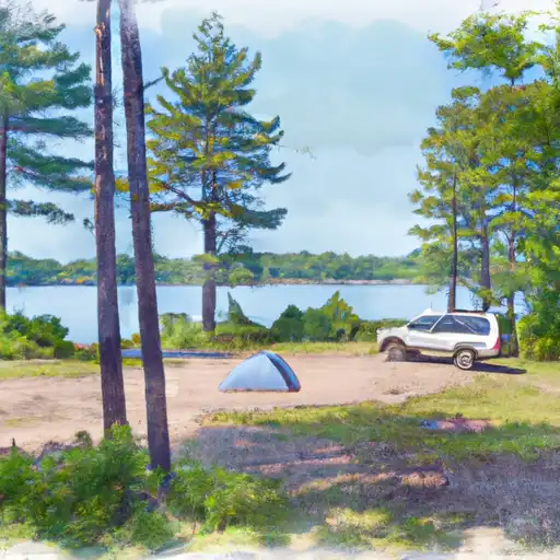
Connors Lake - Flambeau River State Forest Campground
Community Reviews
Been here? Share the conditions.
Reviews, ratings & photos are added in the free Snoflo iOS app — rate a spot, tag the conditions, and your visit is verified by location. Add or manage your reviews from the app.
Connors Lake - Flambeau River State Forest
Reservations are not accepted at Connors Lake campground, and campsites are available on a first-come, first-served basis. It is advisable to arrive early, especially during peak season, to secure a spot. The best time to visit Connors Lake is during the summer months, from June to August, when the weather is pleasant and allows for various outdoor activities like fishing, hiking, and wildlife viewing.
While camping at Connors Lake, campers can enjoy the breathtaking views of the lake and surrounding forest. Fishing enthusiasts will be delighted by the diverse fish population, including bass, walleye, and panfish, making it an ideal spot for angling. However, it is important to be cautious of bears in the area and properly store food to prevent any unwanted encounters. Additionally, visitors should be mindful of any fire restrictions or regulations in place to ensure a safe and enjoyable camping experience.
What's on-site at Connors Lake - Flambeau River State Forest
Key facilities Snoflo tracks for this campground. Confirm with the operator before booking -- amenities can change seasonally.
Plan your trip down to the hour
Same weather feed Snoflo's iOS app uses -- updated continuously from NOAA / yr.no.
Next 5 days, hour by hour
Temperature line with weather symbols on top, snow + rain accumulation as columns, humidity as a dotted line.
5-day forecast table
Every 3 hours, broken out across temperature, snow, rain, humidity, and wind. Each cell is colour-coded relative to the column min/max so trends jump out at a glance.
| Time | Condition | Temp (°F) | Snow (in) | Rain (in) | Humidity (%) | Wind (mps) | Wind dir |
|---|---|---|---|---|---|---|---|
| Loading detailed forecast… | |||||||
15-day temperature & precipitation
Daily temperatures, snow, and rain projected over the next two weeks. Hover any point for the full breakdown.
Other campgrounds in the area
Snoflo-tracked campsites within driving distance of Connors Lake - Flambeau River State Forest, with reservations status.
| Campground | Reservations | Toilets | View |
|---|---|---|---|
| George's Island Camp | ✗ | ✗ | → |
| Boy Scout Camp | ✗ | ✗ | → |
| Headquarter Camp | ✗ | ✗ | → |
| Lake Of The Pines - Flambeau River State Forest | ✗ | ✓ | → |
| Hawkins Lions Club Park | ✗ | ✗ | → |
Nearby streamflow
USGS streamgauges within reach of Connors Lake - Flambeau River State Forest -- pulled live from the National Water Information System.
| Streamgauge | Discharge | View |
|---|---|---|
| Chippewa River At Bishops Bridge Near Winter | 283 cfs | → |
| Jump River At Sheldon | 35 cfs | → |
| Chippewa River Near Bruce | 438 cfs | → |
| Flambeau River Near Bruce | 569 cfs | → |
| Bad River Near Mellen | 101 cfs | → |
| Namekagon River At Leonards | 52 cfs | → |
Nearby snow depths
NRCS SNOTEL stations within reach of Connors Lake - Flambeau River State Forest -- relevant when planning a shoulder-season or alpine trip.
| SNOTEL station | Snowpack | 24h Snowfall | View |
|---|---|---|---|
| Phillips 0.4 Ssw | 0.0 in | 0.0 in | → |
| Butternut 5.9 Sw | 0.0 in | 0.0 in | → |
| Phillips 1.3 S | 0.0 in | 0.0 in | → |
| Butternut 0.2 Nnw | 0.0 in | 0.0 in | → |
| Clam Lake 4w | 0.0 in | 0.0 in | → |
| Nohrsc Clam Lake 4 W | 0.0 in | 0.0 in | → |
Plan a longer trip
The closest parks, lakes, boat launches, and paddle runs so a camping night can grow into a full weekend.
Parks
- Kimberly Clark Wildlife Area
- Silver Nail Wildlife Area
- Flambeau River State Forest
- Rocky Carry Park
- Spring Creek Wildlife Area
- Josie Creek Park
Boat launches
- Connors Lake -- Access At North End Of Lake (Nr Cth W)
- Lake Of The Pines -- Access - Nw Side Of Lake
- South Fork Flambeau River -- Carry-In S Of Hwy W
- Hervas
- Flambeau River
- Le Tourneau Lake -- Ramp
Points of interest
Camping essentials & Leave No Trace
- Pack it in, pack it out
- Take all trash, food scraps, and gear back with you to keep campsites clean and protect wildlife.
- Respect wildlife
- Observe animals from a distance, store food securely, and never feed wildlife to maintain natural behavior and safety.
- Know before you go
- Check weather, fire restrictions, trail conditions, and permit requirements to ensure a safe and well-planned trip.
- Minimize campfire impact
- Use established fire rings, keep fires small, fully extinguish them, or opt for a camp stove when fires are restricted.
- Leave what you find
- Preserve natural and cultural features by avoiding removal of plants, rocks, artifacts, or other elements of the environment.
Set push alerts in the Snoflo app
Save Connors Lake - Flambeau River State Forest as a favorite, set a custom threshold (precipitation, snowpack, freezing temperatures), and the iOS app will push the moment conditions cross.
About Connors Lake - Flambeau River State Forest
Can I make reservations at Connors Lake - Flambeau River State Forest?
This campground does not appear to accept reservations -- it's typically first-come, first-served. Arrive early on summer weekends.
How fresh is the weather data on this page?
The hourly forecast updates throughout the day from the NOAA / yr.no public feeds. Streamflow data is pulled live from USGS streamgauges and snowpack from the NRCS SNOTEL network.
What's the best time of year to visit?
Use the 15-day temperature & precipitation outlook on this page to plan -- pick a window with comfortable temperatures and low precipitation. For longer trips, the 5-day hourly meteogram shows snow + rain accumulation hour-by-hour.
How do I get to Connors Lake - Flambeau River State Forest?
Tap Directions in the hero above to open driving directions in Google Maps, or Open in map to center the Snoflo interactive map on the campground.
Can I get alerts when conditions change?
Yes -- alerts are managed through the Snoflo iOS app. Favorite this campground, set a threshold (temperature, snowpack, precipitation), and you'll get a push the moment it crosses.
Other campgrounds near here
Snoflo-tracked campgrounds within driving distance of Connors Lake - Flambeau River State Forest.