Thain Creek Campground
Community Reviews
Been here? Share the conditions.
Reviews, ratings & photos are added in the free Snoflo iOS app — rate a spot, tag the conditions, and your visit is verified by location. Add or manage your reviews from the app.
Thain Creek
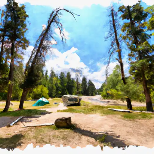
The campground has several amenities, such as picnic tables, fire rings, and toilets. However, there is no potable water available, so campers must bring their own. The camping area is first-come, first-served, and it has 11 campsites that can accommodate tents and RVs up to 16 feet long.
An interesting fact about the Thain Creek Camping Area is that it is named after John Thain, who was a pioneer in the Boulder Valley. He built a cabin nearby in the late 1800s, which can still be seen today.
The best time of year to visit Thain Creek Camping Area is between June and September. During this time, the average temperatures range from the mid-50s to the mid-70s, making it comfortable for camping and outdoor activities. Overall, Thain Creek Camping Area offers a serene and scenic retreat for those seeking a peaceful escape into nature.
What's on-site at Thain Creek
Key facilities Snoflo tracks for this campground. Confirm with the operator before booking -- amenities can change seasonally.
Plan your trip down to the hour
Same weather feed Snoflo's iOS app uses -- updated continuously from NOAA / yr.no.
Next 5 days, hour by hour
Temperature line with weather symbols on top, snow + rain accumulation as columns, humidity as a dotted line.
5-day forecast table
Every 3 hours, broken out across temperature, snow, rain, humidity, and wind. Each cell is colour-coded relative to the column min/max so trends jump out at a glance.
| Time | Condition | Temp (°F) | Snow (in) | Rain (in) | Humidity (%) | Wind (mps) | Wind dir |
|---|---|---|---|---|---|---|---|
| Loading detailed forecast… | |||||||
15-day temperature & precipitation
Daily temperatures, snow, and rain projected over the next two weeks. Hover any point for the full breakdown.
Other campgrounds in the area
Snoflo-tracked campsites within driving distance of Thain Creek, with reservations status.
| Campground | Reservations | Toilets | View |
|---|---|---|---|
| Thain Creek Campground | ✗ | ✗ | → |
| Thain Creek Camp Ground | ✗ | ✗ | → |
| Evans Bend | ✗ | ✗ | → |
| Seineurs Reach | ✗ | ✗ | → |
| Gateway Military - Malmstrom Afb | ✓ | ✓ | → |
Nearby streamflow
USGS streamgauges within reach of Thain Creek -- pulled live from the National Water Information System.
| Streamgauge | Discharge | View |
|---|---|---|
| Missouri River Near Great Falls Mt | 4,090 cfs | → |
| Missouri River At Fort Benton Mt | 4,860 cfs | → |
| Belt Creek Near Monarch Mt | 121 cfs | → |
| Teton River At Loma Mt | 7 cfs | → |
| Marias River Near Loma Mt | 1,400 cfs | → |
| Missouri River Near Ulm Mt | 3,380 cfs | → |
Nearby snow depths
NRCS SNOTEL stations within reach of Thain Creek -- relevant when planning a shoulder-season or alpine trip.
| SNOTEL station | Snowpack | 24h Snowfall | View |
|---|---|---|---|
| Mt Mesonet Coffee Creek N | 0.0 in | 0.0 in | → |
| Fort Benton | 0.0 in | 0.0 in | → |
| Stanford | 0.0 in | 0.0 in | → |
| Loma | 0.0 in | 0.0 in | → |
| Great Falls Airport | 0.0 in | 0.0 in | → |
| Stringer Creek | 0.0 in | 0.0 in | → |
Plan a longer trip
The closest parks, lakes, boat launches, and paddle runs so a camping night can grow into a full weekend.
Parks
- Sluice Boxes State Park
- Pinski Park
- Heren Park
- Giant Springs State Park
- Graybill Park
- Dudley Anderson Park
Fishing spots
Camping essentials & Leave No Trace
- Pack it in, pack it out
- Take all trash, food scraps, and gear back with you to keep campsites clean and protect wildlife.
- Respect wildlife
- Observe animals from a distance, store food securely, and never feed wildlife to maintain natural behavior and safety.
- Know before you go
- Check weather, fire restrictions, trail conditions, and permit requirements to ensure a safe and well-planned trip.
- Minimize campfire impact
- Use established fire rings, keep fires small, fully extinguish them, or opt for a camp stove when fires are restricted.
- Leave what you find
- Preserve natural and cultural features by avoiding removal of plants, rocks, artifacts, or other elements of the environment.
Set push alerts in the Snoflo app
Save Thain Creek as a favorite, set a custom threshold (precipitation, snowpack, freezing temperatures), and the iOS app will push the moment conditions cross.
About Thain Creek
Can I make reservations at Thain Creek?
This campground does not appear to accept reservations -- it's typically first-come, first-served. Arrive early on summer weekends.
How fresh is the weather data on this page?
The hourly forecast updates throughout the day from the NOAA / yr.no public feeds. Streamflow data is pulled live from USGS streamgauges and snowpack from the NRCS SNOTEL network.
What's the best time of year to visit?
Use the 15-day temperature & precipitation outlook on this page to plan -- pick a window with comfortable temperatures and low precipitation. For longer trips, the 5-day hourly meteogram shows snow + rain accumulation hour-by-hour.
How do I get to Thain Creek?
Tap Directions in the hero above to open driving directions in Google Maps, or Open in map to center the Snoflo interactive map on the campground.
Can I get alerts when conditions change?
Yes -- alerts are managed through the Snoflo iOS app. Favorite this campground, set a threshold (temperature, snowpack, precipitation), and you'll get a push the moment it crosses.
Other campgrounds near here
Snoflo-tracked campgrounds within driving distance of Thain Creek.