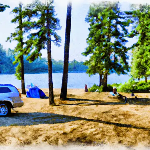
South Navarre campground
Community Reviews
Been here? Share the conditions.
Reviews, ratings & photos are added in the free Snoflo iOS app — rate a spot, tag the conditions, and your visit is verified by location. Add or manage your reviews from the app.
South Navarre
The best time to visit South Navarre camping area is during the summer months, from June to September, when the weather is pleasant and ideal for outdoor activities. Visitors can enjoy hiking, fishing, and wildlife viewing in the surrounding areas. It is worth mentioning that caution should be exercised while camping in this area, as it is known for its bear population. Campers are advised to store food properly and keep a safe distance from wildlife. Additionally, it is recommended to bring bug repellent, as mosquitoes can be quite prevalent in this region.
In conclusion, South Navarre camping area in Washington state offers a peaceful and scenic getaway with its basic amenities and natural surroundings. It is a first-come, first-served campground, so early arrival is recommended. The best time to visit is during the summer months, but campers should be cautious of bears and mosquitoes.
What's on-site at South Navarre
Key facilities Snoflo tracks for this campground. Confirm with the operator before booking -- amenities can change seasonally.
Plan your trip down to the hour
Same weather feed Snoflo's iOS app uses -- updated continuously from NOAA / yr.no.
Next 5 days, hour by hour
Temperature line with weather symbols on top, snow + rain accumulation as columns, humidity as a dotted line.
5-day forecast table
Every 3 hours, broken out across temperature, snow, rain, humidity, and wind. Each cell is colour-coded relative to the column min/max so trends jump out at a glance.
| Time | Condition | Temp (°F) | Snow (in) | Rain (in) | Humidity (%) | Wind (mps) | Wind dir |
|---|---|---|---|---|---|---|---|
| Loading detailed forecast… | |||||||
15-day temperature & precipitation
Daily temperatures, snow, and rain projected over the next two weeks. Hover any point for the full breakdown.
Other campgrounds in the area
Snoflo-tracked campsites within driving distance of South Navarre, with reservations status.
| Campground | Reservations | Toilets | View |
|---|---|---|---|
| South Navarre Campground | ✗ | ✗ | → |
| Safety Harbor Campground [Closed] | ✓ | ✗ | → |
| Safety Harbor Campground | ✗ | ✗ | → |
| Deer Point | ✗ | ✓ | → |
| Deer Point Campground | ✗ | ✗ | → |
Nearby streamflow
USGS streamgauges within reach of South Navarre -- pulled live from the National Water Information System.
| Streamgauge | Discharge | View |
|---|---|---|
| Methow River Near Pateros | 783 cfs | → |
| Entiat River Near Ardenvoir | 186 cfs | → |
| Twisp River Near Twisp | 138 cfs | → |
| Methow River At Twisp | 671 cfs | → |
| Stehekin River At Stehekin | 1,180 cfs | → |
| Chiwawa River Near Plain | 265 cfs | → |
Nearby snow depths
NRCS SNOTEL stations within reach of South Navarre -- relevant when planning a shoulder-season or alpine trip.
| SNOTEL station | Snowpack | 24h Snowfall | View |
|---|---|---|---|
| Pope Ridge | 0.0 in | 0.0 in | → |
| Nohrsc Pope Ridge | 0.0 in | 0.0 in | → |
| Nohrsc Twisp 9.3 W | 0.0 in | 0.0 in | → |
| Holden Village | 0.0 in | 0.0 in | → |
| Trinity | 0.0 in | 0.0 in | → |
| Nohrsc Trinity Snotel | 0.0 in | 0.0 in | → |
Plan a longer trip
The closest parks, lakes, boat launches, and paddle runs so a camping night can grow into a full weekend.
Parks
- Wilderness Lake Chelan-Sawtooth
- Twenty-Five Mile Creek State Park
- Okanogan National Forest
- Lake Chelan State Park
- Lake Chelan National Recreation Area
- Wilderness Stephen Mather
Boat launches
- Twentyfive Mile Creek State Park
- Averill
- Lucerne Campground
- Watson's Harverenes Resort
- Carlton
- Kamei Resort
Points of interest
- Entiat Falls Viewpoint
- Box Canyon Viewpoint
- Golden West Visitor Center
- The Confluence
- Lake Chelan Historical Society Museum
- Beebe Bridge
Paddle runs
- Cottonwood Trailhead To Private Land Boundary In Ne1/4 Of Sec 29, T28n, R19e
- Glacier Peak Wilderness To Cottonwood Trailhead In Sw1/4 Of Sec 7, T28n,R19e
- Lake Chelan-Sawtooth Wilderness Boundary To Private Land Boundary Near Lime Creek In Se1/4 Of Sec 18, T33n, R20e
- Headwaters And Includes All Tributaries To Confluence With Boulder Creek
- Private Land Boundary To Okanogan Nf Boundary
- Headwaters And Includes All Tributaries To Ends 1/4 Mile Upstream Of The Confluence With The Stehekin River
Camping essentials & Leave No Trace
- Pack it in, pack it out
- Take all trash, food scraps, and gear back with you to keep campsites clean and protect wildlife.
- Respect wildlife
- Observe animals from a distance, store food securely, and never feed wildlife to maintain natural behavior and safety.
- Know before you go
- Check weather, fire restrictions, trail conditions, and permit requirements to ensure a safe and well-planned trip.
- Minimize campfire impact
- Use established fire rings, keep fires small, fully extinguish them, or opt for a camp stove when fires are restricted.
- Leave what you find
- Preserve natural and cultural features by avoiding removal of plants, rocks, artifacts, or other elements of the environment.
Set push alerts in the Snoflo app
Save South Navarre as a favorite, set a custom threshold (precipitation, snowpack, freezing temperatures), and the iOS app will push the moment conditions cross.
About South Navarre
Can I make reservations at South Navarre?
This campground does not appear to accept reservations -- it's typically first-come, first-served. Arrive early on summer weekends.
How fresh is the weather data on this page?
The hourly forecast updates throughout the day from the NOAA / yr.no public feeds. Streamflow data is pulled live from USGS streamgauges and snowpack from the NRCS SNOTEL network.
What's the best time of year to visit?
Use the 15-day temperature & precipitation outlook on this page to plan -- pick a window with comfortable temperatures and low precipitation. For longer trips, the 5-day hourly meteogram shows snow + rain accumulation hour-by-hour.
How do I get to South Navarre?
Tap Directions in the hero above to open driving directions in Google Maps, or Open in map to center the Snoflo interactive map on the campground.
Can I get alerts when conditions change?
Yes -- alerts are managed through the Snoflo iOS app. Favorite this campground, set a threshold (temperature, snowpack, precipitation), and you'll get a push the moment it crosses.
Other campgrounds near here
Snoflo-tracked campgrounds within driving distance of South Navarre.