Yellowstone Cliffs Camp campground
Community Reviews
Been here? Share the conditions.
Reviews, ratings & photos are added in the free Snoflo iOS app — rate a spot, tag the conditions, and your visit is verified by location. Add or manage your reviews from the app.
Yellowstone Cliffs Camp
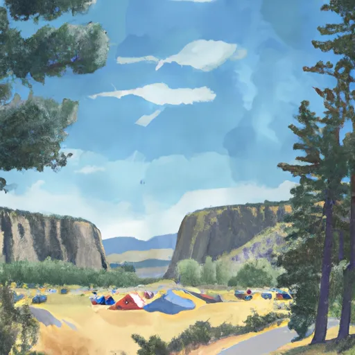
The camping area features a variety of amenities including picnic tables, fire pits, and vault toilets. The campground is first-come-first-serve and operates on a cash-only basis. There are 16 campsites available for tents and RVs up to 16 feet in length.
An interesting fact about the area is that the campground is named after the yellow cliffs visible from the campsites. These cliffs are made up of layers of volcanic ash and pumice that were deposited during the eruption of Mount St. Helens in 1980.
The best time to visit Yellowstone Cliffs Camp is from May through October with average temperatures ranging from the mid-50s to mid-70s. Visitors can enjoy hiking, fishing, and exploring the nearby attractions during this time. Overall, Yellowstone Cliffs Camp is an ideal camping destination for nature enthusiasts looking for a peaceful and scenic getaway.
What's on-site at Yellowstone Cliffs Camp
Key facilities Snoflo tracks for this campground. Confirm with the operator before booking -- amenities can change seasonally.
Plan your trip down to the hour
Same weather feed Snoflo's iOS app uses -- updated continuously from NOAA / yr.no.
Next 5 days, hour by hour
Temperature line with weather symbols on top, snow + rain accumulation as columns, humidity as a dotted line.
5-day forecast table
Every 3 hours, broken out across temperature, snow, rain, humidity, and wind. Each cell is colour-coded relative to the column min/max so trends jump out at a glance.
| Time | Condition | Temp (°F) | Snow (in) | Rain (in) | Humidity (%) | Wind (mps) | Wind dir |
|---|---|---|---|---|---|---|---|
| Loading detailed forecast… | |||||||
15-day temperature & precipitation
Daily temperatures, snow, and rain projected over the next two weeks. Hover any point for the full breakdown.
Other campgrounds in the area
Snoflo-tracked campsites within driving distance of Yellowstone Cliffs Camp, with reservations status.
| Campground | Reservations | Toilets | View |
|---|---|---|---|
| Dick Creek Camp | ✓ | ✗ | → |
| James Camp | ✓ | ✓ | → |
| Cataract Valley Camp | ✓ | ✓ | → |
| Mystic Camp | ✓ | ✗ | → |
| Ipsut Creek Campground | ✓ | ✓ | → |
Nearby streamflow
USGS streamgauges within reach of Yellowstone Cliffs Camp -- pulled live from the National Water Information System.
| Streamgauge | Discharge | View |
|---|---|---|
| Puyallup River Near Electron | 421 cfs | → |
| Carbon River Near Fairfax | 318 cfs | → |
| White River Below Clearwater River Nr Buckley | 2,550 cfs | → |
| Greenwater River At Greenwater | 52 cfs | → |
| White River Above Boise Creek At Buckley | 485 cfs | → |
| Boise Creek At Buckley | 9 cfs | → |
Nearby snow depths
NRCS SNOTEL stations within reach of Yellowstone Cliffs Camp -- relevant when planning a shoulder-season or alpine trip.
| SNOTEL station | Snowpack | 24h Snowfall | View |
|---|---|---|---|
| Mowich | 0.0 in | 0.0 in | → |
| Burnt Mountain | 0.0 in | 0.0 in | → |
| Nohrsc Burnt Mountain | 0.0 in | 0.0 in | → |
| Nohrsc Huckleberry Creek | 0.0 in | 0.0 in | → |
| Huckleberry Creek | 0.0 in | 0.0 in | → |
| Paradise | 3.5 in | 0.0 in | → |
Plan a longer trip
The closest parks, lakes, boat launches, and paddle runs so a camping night can grow into a full weekend.
Parks
- Wilderness Clearwater
- Federation Forest State Park
- Wilderness Glacier View
- Wilderness Norse Peak
- Wilkeson Creek County Park
- King County Enumclaw Park
Boat launches
- Orville Road East 29517, Orting
- Bumping Lake Marina
- Bumping Lake Public Boat Landing
- Benbow Resort
- Lake Whitman
- State Game Road 11999, Pierce County
Points of interest
Paddle runs
- Headwaters On The Nw Slope Of Mount Rainier At Carbon Glacier To Confluence With Ipsut Creek
- Headwaters In The Mystic Lake Basin On The North Side Of Mount Rainier To Northern Boundary Of Mount Rainier National Park
- Confluence With Ipsut Creek To Western Boundary Of Mount Rainier National Park
- Headwaters On The Southeast Flank Of Mount Rainier At An Elevation Of 5500 Ft To Confluence With Chinook Creek
- Headwaters At The Terminus Of The Ingraham Glacier To Ends 1/4 Mile North Of Box Canyon
- Mt. Baker-Snoqualmie Nf/Mt. Ranier Np Boundary At North Section Line Of Sec 3, T17 N, R10e To Confluence With Huckleberry Creek
Camping essentials & Leave No Trace
- Pack it in, pack it out
- Take all trash, food scraps, and gear back with you to keep campsites clean and protect wildlife.
- Respect wildlife
- Observe animals from a distance, store food securely, and never feed wildlife to maintain natural behavior and safety.
- Know before you go
- Check weather, fire restrictions, trail conditions, and permit requirements to ensure a safe and well-planned trip.
- Minimize campfire impact
- Use established fire rings, keep fires small, fully extinguish them, or opt for a camp stove when fires are restricted.
- Leave what you find
- Preserve natural and cultural features by avoiding removal of plants, rocks, artifacts, or other elements of the environment.
Set push alerts in the Snoflo app
Save Yellowstone Cliffs Camp as a favorite, set a custom threshold (precipitation, snowpack, freezing temperatures), and the iOS app will push the moment conditions cross.
About Yellowstone Cliffs Camp
Can I make reservations at Yellowstone Cliffs Camp?
Yes -- this campground accepts reservations. Snoflo recommends booking early for peak season; check the operator (Recreation.gov / state park system / private operator) for the booking window and cancellation policy.
How fresh is the weather data on this page?
The hourly forecast updates throughout the day from the NOAA / yr.no public feeds. Streamflow data is pulled live from USGS streamgauges and snowpack from the NRCS SNOTEL network.
What's the best time of year to visit?
Use the 15-day temperature & precipitation outlook on this page to plan -- pick a window with comfortable temperatures and low precipitation. For longer trips, the 5-day hourly meteogram shows snow + rain accumulation hour-by-hour.
How do I get to Yellowstone Cliffs Camp?
Tap Directions in the hero above to open driving directions in Google Maps, or Open in map to center the Snoflo interactive map on the campground.
Can I get alerts when conditions change?
Yes -- alerts are managed through the Snoflo iOS app. Favorite this campground, set a threshold (temperature, snowpack, precipitation), and you'll get a push the moment it crosses.
Other campgrounds near here
Snoflo-tracked campgrounds within driving distance of Yellowstone Cliffs Camp.