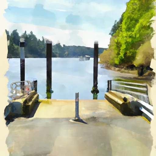
Orville Road East 39200-41144, Eatonville Boat Launch
Community Reviews
Been here? Share the conditions.
Reviews, ratings & photos are added in the free Snoflo iOS app — rate a spot, tag the conditions, and your visit is verified by location. Add or manage your reviews from the app.
Orville Road East 39200-41144, Eatonville
This boat ramp is suitable for small to medium-sized boats. Usually, boats no larger than 20 feet in length are allowed to launch from this ramp. However, it is always recommended to check the latest information on the Washington Department of Fish and Wildlife website or contact them directly for specific regulations and restrictions.
The Alder Lake is well known for fishing, water skiing, and other recreational activities. It is a popular spot for both locals and tourists alike. The lake is stocked with various fish species, including rainbow trout, coho salmon, and smallmouth bass, making it an ideal destination for anglers.
In conclusion, Orville Road East boat ramp is a concrete boat ramp located in Eatonville, Washington, that provides access to the Alder Lake. It is suitable for small to medium-sized boats, and the lake is known for various water recreational activities and fishing opportunities.
Plan your launch down to the hour
Same weather feed Snoflo's iOS app uses -- updated continuously from NOAA / yr.no.
Next 5 days, hour by hour
Temperature line with weather symbols on top, snow + rain accumulation as columns, humidity as a dotted line.
5-day forecast table
Every 3 hours, broken out across temperature, snow, rain, humidity, and wind.
| Time | Condition | Temp (°F) | Snow (in) | Rain (in) | Humidity (%) | Wind (mps) | Wind dir |
|---|---|---|---|---|---|---|---|
| Loading detailed forecast… | |||||||
15-day temperature & precipitation
Daily temperatures, snow, and rain projected over the next two weeks.
Area streamflow levels
USGS streamgauges around Orville Road East 39200-41144, Eatonville -- the same readings that determine whether your launch is safe and your boat is the right craft.
| Streamgauge | Discharge | View |
|---|---|---|
| Ohop Creek Near Eatonville | 4 cfs | → |
| Mashel River Near La Grande | 8 cfs | → |
| Nisqually River At La Grande | 749 cfs | → |
| Nisqually River At La Grande Dam | 37 cfs | → |
| Centralia Power Canal Near Mckenna | 164 cfs | → |
| Puyallup River Near Orting | 938 cfs | → |
Plan a longer trip
The closest paddle runs, fishing spots, and other boat launches so you can extend a day on the water.
River runs
- Confluence With Ipsut Creek To Western Boundary Of Mount Rainier National Park
- Headwaters On The Nw Slope Of Mount Rainier At Carbon Glacier To Confluence With Ipsut Creek
- Headwaters In The Mystic Lake Basin On The North Side Of Mount Rainier To Northern Boundary Of Mount Rainier National Park
- Huckleberry Creek To Confluence With Clearwater River
- Headwaters At The Terminus Of The Ingraham Glacier To Ends 1/4 Mile North Of Box Canyon
- Headwaters On The Southeast Flank Of Mount Rainier At An Elevation Of 5500 Ft To Confluence With Chinook Creek
Boating safety & etiquette
- Check the conditions before you launch
- Use the streamflow numbers, weather, and wind forecast on this page. High-cfs whitewater requires whitewater-specific craft and skill.
- Wear your life jacket
- Statistically the single biggest survival factor in a boating incident. State law often requires one per passenger.
- File a float plan
- Tell someone on shore your put-in, take-out, and expected return time. Especially for multi-day or remote trips.
- Yield at the ramp
- Prep gear in the parking lot, not on the ramp. Launch and clear quickly so others can use the lane.
- Clean, drain, dry
- Inspect, clean, drain and dry your boat between waters to prevent the spread of aquatic invasive species.
Set push alerts in the Snoflo app
Save Orville Road East 39200-41144, Eatonville as a favorite, set a discharge threshold or a wind/precipitation alert, and the iOS app will push the moment conditions cross.
About Orville Road East 39200-41144, Eatonville
Can I launch a motorboat here?
Most Snoflo-tracked launches support motorboats; check the operator for any horsepower restrictions, paddle-only zones, or seasonal closures.
How fresh is the streamflow data?
USGS streamgauges report continuously (every 15 minutes); the table on this page pulls the latest reading at page load.
Is there a fee?
Many federal and state boat launches charge a day-use fee. Check the operator's site before driving out.
What boat is right for these conditions?
Use the nearby streamflow numbers and river-run panel on this page to gauge current conditions. Wider, slower water is friendly for casual paddling and powerboats; high-cfs whitewater requires whitewater-specific craft and skill.
Can I get alerts when conditions change?
Yes -- alerts are managed in the Snoflo iOS app. Favorite this launch, set a threshold (discharge, wind), and you'll get a push the moment it crosses.
Other launches near here
Snoflo-tracked boat launches within driving distance of Orville Road East 39200-41144, Eatonville.