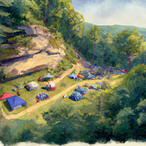
Coopers Rock State Forest campground
Community Reviews
Been here? Share the conditions.
Reviews, ratings & photos are added in the free Snoflo iOS app — rate a spot, tag the conditions, and your visit is verified by location. Add or manage your reviews from the app.
Coopers Rock State Forest
Reservations are accepted at Coopers Rock State Forest, which allows campers to secure a spot in advance. This is especially recommended during peak seasons when the campground tends to fill up quickly. It is important to note that campsites are available on a first-come, first-served basis if not reserved.
The best time of year to visit Coopers Rock State Forest is during the spring and fall seasons. These times offer pleasant weather conditions and beautiful foliage. However, it is important to be prepared for changing weather conditions as temperatures can drop significantly, even during the summer months. Additionally, campers should be cautious of poison ivy and ticks that can be found in the area. It is advised to wear appropriate clothing and use insect repellent to prevent any discomfort or health issues.
In summary, Coopers Rock State Forest provides a well-equipped camping area with amenities such as campsites, restrooms, and recreational facilities. Reservation options are available, and the best time to visit is during the spring and fall seasons. Campers should be mindful of poison ivy and ticks in the area. With its natural beauty and convenient amenities, Coopers Rock State Forest offers an ideal camping experience for outdoor enthusiasts.
What's on-site at Coopers Rock State Forest
Key facilities Snoflo tracks for this campground. Confirm with the operator before booking -- amenities can change seasonally.
Plan your trip down to the hour
Same weather feed Snoflo's iOS app uses -- updated continuously from NOAA / yr.no.
Next 5 days, hour by hour
Temperature line with weather symbols on top, snow + rain accumulation as columns, humidity as a dotted line.
5-day forecast table
Every 3 hours, broken out across temperature, snow, rain, humidity, and wind. Each cell is colour-coded relative to the column min/max so trends jump out at a glance.
| Time | Condition | Temp (°F) | Snow (in) | Rain (in) | Humidity (%) | Wind (mps) | Wind dir |
|---|---|---|---|---|---|---|---|
| Loading detailed forecast… | |||||||
15-day temperature & precipitation
Daily temperatures, snow, and rain projected over the next two weeks. Hover any point for the full breakdown.
Other campgrounds in the area
Snoflo-tracked campsites within driving distance of Coopers Rock State Forest, with reservations status.
| Campground | Reservations | Toilets | View |
|---|---|---|---|
| Chestnut Ridge Regional Park | ✗ | ✗ | → |
| Marvin's Mountaintop | ✗ | ✗ | → |
| Tall Oaks Campground | ✗ | ✗ | → |
| Mason - Dixon Historical Park | ✗ | ✓ | → |
| Camp Sonrise Mountain Christian Retreat Center | ✗ | ✗ | → |
Nearby streamflow
USGS streamgauges within reach of Coopers Rock State Forest -- pulled live from the National Water Information System.
| Streamgauge | Discharge | View |
|---|---|---|
| Big Sandy Creek At Rockville | 92 cfs | → |
| Deckers Creek At Morgantown | 39 cfs | → |
| Dunkard Creek At Shannopin | 74 cfs | → |
| Cheat River At Albright | 1,300 cfs | → |
| Monongahela River Near Masontown | 4,040 cfs | → |
| Youghiogheny River At Friendsville | 203 cfs | → |
Nearby snow depths
NRCS SNOTEL stations within reach of Coopers Rock State Forest -- relevant when planning a shoulder-season or alpine trip.
| SNOTEL station | Snowpack | 24h Snowfall | View |
|---|---|---|---|
| Bruceton Mills 2.8 S | 0.0 in | 0.0 in | → |
| Point Marion Dam | 0.0 in | 0.0 in | → |
| Morgantown 5.9 Sw | 0.0 in | 0.0 in | → |
| Grays Landing Dam | 0.0 in | 0.0 in | → |
| Bruceton Mills 9.3 Se | 0.0 in | 0.0 in | → |
| Sines Deep Creek Lake | 0.0 in | 0.0 in | → |
Plan a longer trip
The closest parks, lakes, boat launches, and paddle runs so a camping night can grow into a full weekend.
Parks
- Quebec Run Wild Area
- St Markellos Park
- State Game Lands 138
- Krepps Park
- Friendship Hill National Historic Site
- Fairchance Community Park
Boat launches
- Coopers Rock
- Sunset Harbor Marina
- Mon River Trail North Monongalia County
- Point Marion
- Morgantown
- Monongahela River
Fishing spots
- Bruceton Mills Public Fishing Area
- Deep Creek Lake
- Snowy Creek
- Broadford Lake
- Little Youghiogheny River Reservoir
- Savage River Reservoir
Points of interest
Paddle runs
- Begins As River Passes Under The Herrington Manor Road Bridge At Oakland, Maryland To The Corporate Boundary Of Friendsville, Maryland
- Begins Below The Youghiogheny River Lake Dam In Confluence, Pennsylvania To Ends In South Connellsville, Pennsylvania
- North Fork To Hickory Lick Run
- State Park Bridge To North Fork
- Route 33/8 To Jobs Run Near Porterwood
- Otter Creek To Blackwater
Camping essentials & Leave No Trace
- Pack it in, pack it out
- Take all trash, food scraps, and gear back with you to keep campsites clean and protect wildlife.
- Respect wildlife
- Observe animals from a distance, store food securely, and never feed wildlife to maintain natural behavior and safety.
- Know before you go
- Check weather, fire restrictions, trail conditions, and permit requirements to ensure a safe and well-planned trip.
- Minimize campfire impact
- Use established fire rings, keep fires small, fully extinguish them, or opt for a camp stove when fires are restricted.
- Leave what you find
- Preserve natural and cultural features by avoiding removal of plants, rocks, artifacts, or other elements of the environment.
Set push alerts in the Snoflo app
Save Coopers Rock State Forest as a favorite, set a custom threshold (precipitation, snowpack, freezing temperatures), and the iOS app will push the moment conditions cross.
About Coopers Rock State Forest
Can I make reservations at Coopers Rock State Forest?
Yes -- this campground accepts reservations. Snoflo recommends booking early for peak season; check the operator (Recreation.gov / state park system / private operator) for the booking window and cancellation policy.
How fresh is the weather data on this page?
The hourly forecast updates throughout the day from the NOAA / yr.no public feeds. Streamflow data is pulled live from USGS streamgauges and snowpack from the NRCS SNOTEL network.
What's the best time of year to visit?
Use the 15-day temperature & precipitation outlook on this page to plan -- pick a window with comfortable temperatures and low precipitation. For longer trips, the 5-day hourly meteogram shows snow + rain accumulation hour-by-hour.
How do I get to Coopers Rock State Forest?
Tap Directions in the hero above to open driving directions in Google Maps, or Open in map to center the Snoflo interactive map on the campground.
Can I get alerts when conditions change?
Yes -- alerts are managed through the Snoflo iOS app. Favorite this campground, set a threshold (temperature, snowpack, precipitation), and you'll get a push the moment it crosses.
Other campgrounds near here
Snoflo-tracked campgrounds within driving distance of Coopers Rock State Forest.