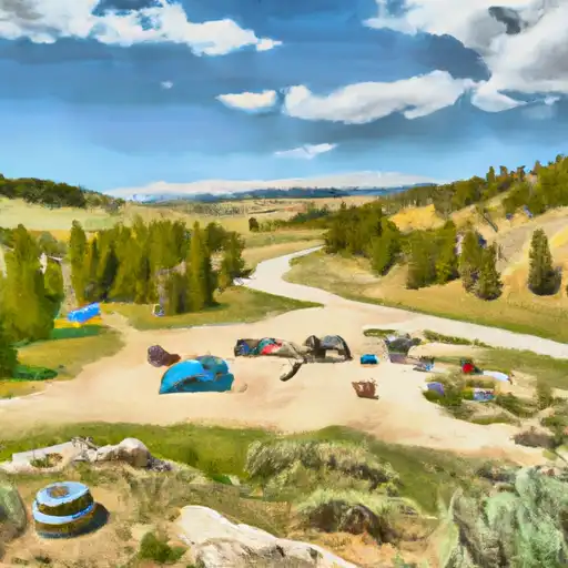
Tie Flume Campground
Community Reviews
Been here? Share the conditions.
Reviews, ratings & photos are added in the free Snoflo iOS app — rate a spot, tag the conditions, and your visit is verified by location. Add or manage your reviews from the app.
Tie Flume
The Tie Flume campground offers 13 campsites, each with a fire ring and a picnic table. The area is also home to a historic tie flume, which was used in the early 1900s to transport railroad ties down the mountain. A quirky fact about the area is that it was named after the tie flume, which was essentially a water slide for railroad ties.
The best time to visit the Tie Flume Camping Area is in the summer months, from June to September. During this time, the average temperature ranges from the mid-70s during the day to the low 40s at night. Visitors should be prepared for cooler temperatures at higher elevations and should bring warm clothing and sleeping bags. Overall, the Tie Flume Camping Area is a great destination for those looking to immerse themselves in the natural beauty of Wyoming's mountains and forests.
What's on-site at Tie Flume
Key facilities Snoflo tracks for this campground. Confirm with the operator before booking -- amenities can change seasonally.
Plan your trip down to the hour
Same weather feed Snoflo's iOS app uses -- updated continuously from NOAA / yr.no.
Next 5 days, hour by hour
Temperature line with weather symbols on top, snow + rain accumulation as columns, humidity as a dotted line.
5-day forecast table
Every 3 hours, broken out across temperature, snow, rain, humidity, and wind. Each cell is colour-coded relative to the column min/max so trends jump out at a glance.
| Time | Condition | Temp (°F) | Snow (in) | Rain (in) | Humidity (%) | Wind (mps) | Wind dir |
|---|---|---|---|---|---|---|---|
| Loading detailed forecast… | |||||||
15-day temperature & precipitation
Daily temperatures, snow, and rain projected over the next two weeks. Hover any point for the full breakdown.
Other campgrounds in the area
Snoflo-tracked campsites within driving distance of Tie Flume, with reservations status.
| Campground | Reservations | Toilets | View |
|---|---|---|---|
| Tie Flume Campground | ✓ | ✗ | → |
| Dead Swede | ✓ | ✓ | → |
| Dead Swede Campground | ✗ | ✗ | → |
| Owen Creek Campground | ✗ | ✗ | → |
| Owen Creek | ✓ | ✓ | → |
Nearby streamflow
USGS streamgauges within reach of Tie Flume -- pulled live from the National Water Information System.
| Streamgauge | Discharge | View |
|---|---|---|
| Tongue River Near Dayton | 48 cfs | → |
| Shell Creek Above Shell Creek Reservoir | 12 cfs | → |
| Shell Creek Near Shell | 74 cfs | → |
| West Pass Creek Near Parkman | 10 cfs | → |
| East Pass Creek Near Dayton | 12 cfs | → |
| Little Bighorn River At State Line Nr Wyola Mt | 89 cfs | → |
Nearby snow depths
NRCS SNOTEL stations within reach of Tie Flume -- relevant when planning a shoulder-season or alpine trip.
| SNOTEL station | Snowpack | 24h Snowfall | View |
|---|---|---|---|
| Nohrsc Sucker Creek | 0.0 in | 0.0 in | → |
| Sucker Creek | 0.0 in | 0.0 in | → |
| Nohrsc Burgess Junction | 0.0 in | 0.0 in | → |
| Bone Springs Div | 0.0 in | 0.0 in | → |
| Burgess Junction | 0.0 in | 0.0 in | → |
| Nohrsc Bone Springs Divide Snotel | 0.0 in | 0.0 in | → |
Plan a longer trip
The closest parks, lakes, boat launches, and paddle runs so a camping night can grow into a full weekend.
Fishing spots
- Tongue River Fishing Site
- Tongue River Fishing East
- Tongue River Fishing West
- Upper Paintrock Fishing Site
- Sheridan Fairgrounds Pond
- Lake Desmet
Camping essentials & Leave No Trace
- Pack it in, pack it out
- Take all trash, food scraps, and gear back with you to keep campsites clean and protect wildlife.
- Respect wildlife
- Observe animals from a distance, store food securely, and never feed wildlife to maintain natural behavior and safety.
- Know before you go
- Check weather, fire restrictions, trail conditions, and permit requirements to ensure a safe and well-planned trip.
- Minimize campfire impact
- Use established fire rings, keep fires small, fully extinguish them, or opt for a camp stove when fires are restricted.
- Leave what you find
- Preserve natural and cultural features by avoiding removal of plants, rocks, artifacts, or other elements of the environment.
Set push alerts in the Snoflo app
Save Tie Flume as a favorite, set a custom threshold (precipitation, snowpack, freezing temperatures), and the iOS app will push the moment conditions cross.
About Tie Flume
Can I make reservations at Tie Flume?
Yes -- this campground accepts reservations. Snoflo recommends booking early for peak season; check the operator (Recreation.gov / state park system / private operator) for the booking window and cancellation policy.
How fresh is the weather data on this page?
The hourly forecast updates throughout the day from the NOAA / yr.no public feeds. Streamflow data is pulled live from USGS streamgauges and snowpack from the NRCS SNOTEL network.
What's the best time of year to visit?
Use the 15-day temperature & precipitation outlook on this page to plan -- pick a window with comfortable temperatures and low precipitation. For longer trips, the 5-day hourly meteogram shows snow + rain accumulation hour-by-hour.
How do I get to Tie Flume?
Tap Directions in the hero above to open driving directions in Google Maps, or Open in map to center the Snoflo interactive map on the campground.
Can I get alerts when conditions change?
Yes -- alerts are managed through the Snoflo iOS app. Favorite this campground, set a threshold (temperature, snowpack, precipitation), and you'll get a push the moment it crosses.
Other campgrounds near here
Snoflo-tracked campgrounds within driving distance of Tie Flume.