Tower Falls - Yellowstone National Park Campground
Community Reviews
Been here? Share the conditions.
Reviews, ratings & photos are added in the free Snoflo iOS app — rate a spot, tag the conditions, and your visit is verified by location. Add or manage your reviews from the app.
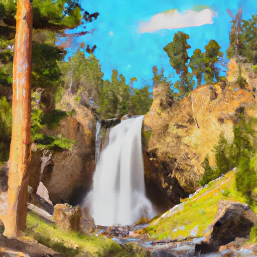
Tower Falls - Yellowstone National Park
The campground offers amenities such as picnic tables, fire rings, and access to potable water and restrooms. The campground operates on a first-come, first-serve basis, with a total of 32 campsites available.
One quirky fact about the area is that Tower Fall was once called "Minaret" by early explorers due to its resemblance to a Turkish minaret.
The best time of year to visit the Tower Falls campground is from late May to early September when the temperatures range from the mid-60s to low 80s. However, visitors should be aware that the campground is located at an elevation of 6,500 feet, so temperatures can drop significantly at night.
In summary, the Tower Falls campground is a great option for those looking to explore the natural beauty of Yellowstone National Park in Wyoming. With stunning views, nearby points of interest, and basic camping amenities, this campground is a great choice for anyone looking to experience the great outdoors.
What's on-site at Tower Falls - Yellowstone National Park
Key facilities Snoflo tracks for this campground. Confirm with the operator before booking -- amenities can change seasonally.
Plan your trip down to the hour
Same weather feed Snoflo's iOS app uses -- updated continuously from NOAA / yr.no.
Next 5 days, hour by hour
Temperature line with weather symbols on top, snow + rain accumulation as columns, humidity as a dotted line.
5-day forecast table
Every 3 hours, broken out across temperature, snow, rain, humidity, and wind. Each cell is colour-coded relative to the column min/max so trends jump out at a glance.
| Time | Condition | Temp (°F) | Snow (in) | Rain (in) | Humidity (%) | Wind (mps) | Wind dir |
|---|---|---|---|---|---|---|---|
| Loading detailed forecast… | |||||||
15-day temperature & precipitation
Daily temperatures, snow, and rain projected over the next two weeks. Hover any point for the full breakdown.
Other campgrounds in the area
Snoflo-tracked campsites within driving distance of Tower Falls - Yellowstone National Park, with reservations status.
| Campground | Reservations | Toilets | View |
|---|---|---|---|
| Tower Fall Campground | ✗ | ✗ | → |
| Agate Creek | ✓ | ✗ | → |
| Slough Creek - Yellowstone National Park | ✗ | ✓ | → |
| Slough Creek Campground | ✗ | ✗ | → |
| 2h6 | ✗ | ✗ | → |
Nearby streamflow
USGS streamgauges within reach of Tower Falls - Yellowstone National Park -- pulled live from the National Water Information System.
| Streamgauge | Discharge | View |
|---|---|---|
| Lamar River Nr Tower Falls Ranger Station Ynp | 423 cfs | → |
| Boiling River At Mammoth | 22 cfs | → |
| Gardner River Near Mammoth Ynp | 167 cfs | → |
| Tantalus Creek At Norris Junction | 3 cfs | → |
| Soda Butte Cr At Park Bndry At Silver Gate | 54 cfs | → |
| Yellowstone River At Yellowstone Lk Outlet Ynp | 2,470 cfs | → |
Nearby snow depths
NRCS SNOTEL stations within reach of Tower Falls - Yellowstone National Park -- relevant when planning a shoulder-season or alpine trip.
| SNOTEL station | Snowpack | 24h Snowfall | View |
|---|---|---|---|
| Tower Falls Rs - Coop | 0.0 in | 0.0 in | → |
| Canyon | 0.0 in | 0.0 in | → |
| Nohrsc Canyon Snotel | 0.0 in | 0.0 in | → |
| Nohrsc Northeast Entrance | 0.0 in | 0.0 in | → |
| Northeast Entrance | 0.0 in | 0.0 in | → |
| Nohrsc Monument Peak | 0.0 in | 0.0 in | → |
Plan a longer trip
The closest parks, lakes, boat launches, and paddle runs so a camping night can grow into a full weekend.
Fishing spots
Points of interest
- Devil's Den
- Tower Fall
- Petrified Tree
- Mount Washburn Northeast View Webcam
- Mount Washburn South View Webcam
- Lamar Buffalo Ranch
Paddle runs
- Begins 1/4 Mile Upstream From Northeast Entrance Road Bridge In The Area Of Tower Falls/ Roosevelt To Ends 1/4 Mile Downstream From Northeast Entrance Road Bridge In The Area Of Tower Falls/ Roosevelt
- Begins 1/4 Mile Downstream From Northeast Entrance Road Bridge In The Area Of Tower Falls/ Roosevelt To Northern Park Boundary
- Begins Above Slough Creek Campground, Located On A Secondary Spur Road To The Park's Main Road To The Confluence With Lamar River
- The Confluence With Soda Butte Creek To The Confluence With The Yellowstone River
- The Headwaters, In The Washburn Range To Ends Above Blanding Hill And The Road Access To Virginia Cascades
- Lower Falls To Ends 1/4 Mile Upstream From Northeast Enternace Road Bridge In The Area Of Tower Falls/ Roosevelt
Camping essentials & Leave No Trace
- Pack it in, pack it out
- Take all trash, food scraps, and gear back with you to keep campsites clean and protect wildlife.
- Respect wildlife
- Observe animals from a distance, store food securely, and never feed wildlife to maintain natural behavior and safety.
- Know before you go
- Check weather, fire restrictions, trail conditions, and permit requirements to ensure a safe and well-planned trip.
- Minimize campfire impact
- Use established fire rings, keep fires small, fully extinguish them, or opt for a camp stove when fires are restricted.
- Leave what you find
- Preserve natural and cultural features by avoiding removal of plants, rocks, artifacts, or other elements of the environment.
Set push alerts in the Snoflo app
Save Tower Falls - Yellowstone National Park as a favorite, set a custom threshold (precipitation, snowpack, freezing temperatures), and the iOS app will push the moment conditions cross.
About Tower Falls - Yellowstone National Park
Can I make reservations at Tower Falls - Yellowstone National Park?
This campground does not appear to accept reservations -- it's typically first-come, first-served. Arrive early on summer weekends.
How fresh is the weather data on this page?
The hourly forecast updates throughout the day from the NOAA / yr.no public feeds. Streamflow data is pulled live from USGS streamgauges and snowpack from the NRCS SNOTEL network.
What's the best time of year to visit?
Use the 15-day temperature & precipitation outlook on this page to plan -- pick a window with comfortable temperatures and low precipitation. For longer trips, the 5-day hourly meteogram shows snow + rain accumulation hour-by-hour.
How do I get to Tower Falls - Yellowstone National Park?
Tap Directions in the hero above to open driving directions in Google Maps, or Open in map to center the Snoflo interactive map on the campground.
Can I get alerts when conditions change?
Yes -- alerts are managed through the Snoflo iOS app. Favorite this campground, set a threshold (temperature, snowpack, precipitation), and you'll get a push the moment it crosses.
Other campgrounds near here
Snoflo-tracked campgrounds within driving distance of Tower Falls - Yellowstone National Park.