Jefferson-City

Climate Recreation Community Catastrophe

Jefferson-City
Eden Index

Climate 8.3 Recreation 3.1 Community 2.9 Safeguard

5.1/10

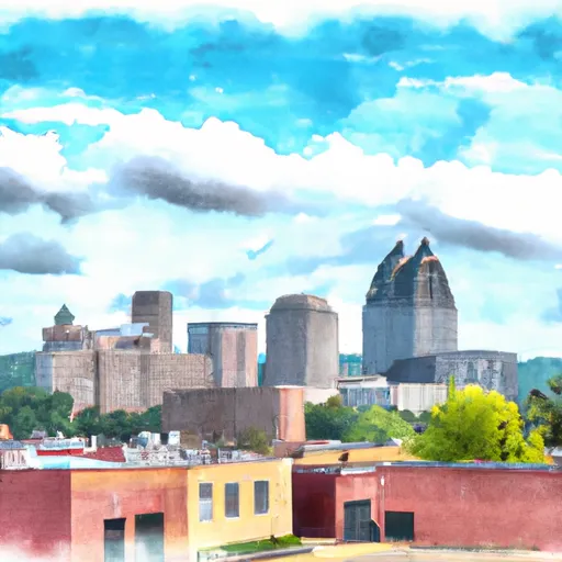
Jefferson City, Missouri, the capital of the state, is located in the central part of the state along the Missouri River. The city experiences a humid continental climate, characterized by hot summers and cold winters. Summers are typically warm and humid, with temperatures averaging around 85°F (29°C), while winters can be cold with average temperatures around 30°F (-1°C). Precipitation is fairly evenly distributed throughout the year, with the highest rainfall occurring in spring and summer.

Being situated along the Missouri River, hydrology plays a significant role in Jefferson City. The river provides opportunities for boating, fishing, and other water-based activities. Additionally, Binder Lake and the smaller Moreau River offer further recreational opportunities for outdoor enthusiasts.

The city is surrounded by numerous parks and outdoor spaces, including the sprawling and picturesque Jefferson City Greenway Trail, which provides opportunities for hiking, biking, and wildlife observation. Other notable outdoor attractions in Jefferson City include the sprawling 630-acre Runge Nature Center, which offers miles of trails and educational exhibits, and the Katy Trail, a popular hiking and biking trail that stretches across the state.

Overall, Jefferson City offers a diverse range of outdoor recreation opportunities, complemented by its unique climate and hydrological constituents, making it an appealing destination for nature lovers and adventure seekers alike.

What is the Eden Index?

The Snoflo Eden Index serves as a comprehensive rating system for regions, evaluating their desirability through a holistic assessment of climate health, outdoor recreation opportunities, and natural disaster risk, acknowledging the profound impact of these factors on livability and well-being.


Climate Health Indicator (CHI): 8.3


Jefferson-City receives approximately 1063mm of rain per year, with humidity levels near 84% and air temperatures averaging around 13°C. Jefferson-City has a plant hardyness factor of 6, meaning plants and agriculture in this region thrive during a short period during spring and early summer. Most plants will die off during the colder winter months. By considering the ideal temperature range, reliable water supplies, clean air, and stable seasonal rain or snowpacks, the Climate Health Indicator (CHI) underscores the significance of a healthy climate as the foundation for quality living.

A healthy climate is paramount for ensuring a high quality of life and livability in a region, fostering both physical well-being and environmental harmony. This can be characterized by ideal temperatures, reliable access to water supplies, clean air, and consistent seasonal rain or snowpacks.


Weather Forecast


Streamflow Conditions

Lower Missouri-Blackwater

Area Rivers

Lower Missouri-Blackwater


Snowpack Depths

Lower Missouri-Blackwater


Reservoir Storage Capacity

Lower Missouri-Blackwater


Groundwater Levels


Recreational Opportunity Index (ROI): 3.1


The Recreational Opportunity Index (ROI) recognizes the value of outdoor recreational options, such as parks, hiking trails, camping sites, and fishing spots, while acknowledging that climate plays a pivotal role in ensuring the comfort and consistency of these experiences. Access to outdoor recreational opportunities, encompassing activities such as parks, hiking, camping, and fishing, is crucial for overall well-being, and the climate plays a pivotal role in enabling and enhancing these experiences, ensuring that individuals can engage in nature-based activities comfortably and consistently.


Camping Areas

Campground Campsites Reservations Toilets Showers Elevation
Waubonsie Trail Park 7 784 ft
Paddy Creek 36 1,008 ft
Moro Bay State Park None 90 ft
Lacey - Keosauqua State Park 113 744 ft
Robinson Point - Norfolk Lake None 605 ft
Panther Bay - Norfolk Lake None 639 ft
Finger Lakes State Park None 725 ft
Willow Beach None 243 ft
Rodgers County Park 50 832 ft
Skunk River Access None 630 ft
Hannen County Park 90 817 ft
Lake Iowa County Park 122 892 ft
Manhattan Bridge Access None 644 ft
Siggelkov County Park None 945 ft
Chacauqua River Access None 721 ft
Bidwell Point - Norfolk Lake None 549 ft
Pine Ridge 8 770 ft
North Woods Park None 1,080 ft
Dry Fork 18 763 ft
Binder Park 17 655 ft
Georges Cove - Norfolk Lake None 633 ft
Lake Sugema County Park None 741 ft
Blanchard Springs 254 638 ft
Sever Lake Conservation Area - MDC 84 736 ft
Saracen Trace RV Park 52 217 ft
Downing County Park None 1,028 ft
Alcock Park 40 1,018 ft
Roubidoux Springs None 775 ft
Milroy Access 95 783 ft
Hickory Hills Park - La Porte City 80 911 ft
Sycamore Loop Dispersed - Noblett Lake None 905 ft
Grand Marais County Park None 79 ft
Tar Camp None 238 ft
Belva - Deer Rec Area 56 828 ft
Minne Estema Park 30 870 ft
Gunner Pool 40 492 ft
Split Rock County Park 54 1,069 ft
Burns Park 38 280 ft
McFarlane Park None 804 ft
Piney River Military - Fort Leonard Wood None 768 ft
Deerwood City Park None 838 ft
Pine Bluff Aresenal Military None 243 ft
Woods Point - Norfolk Lake 11 548 ft
Austin County Park None 578 ft
Barkshed 6 559 ft
Cranfield - Norfolk Lake None 566 ft
Henderson - Norfolk Lake None 590 ft
Hoefle - Dulin Area County Park 16 774 ft
Cutshall Area None 921 ft
Lime Creek Park - Brandon None 858 ft
Downtown Riverside RV Park 69 250 ft
Yenruogis County Park None 799 ft
Patrick Bridge Access - MDC 12 613 ft
Crossett RV Park 119 68 ft
Little Rock AFB Military None 352 ft
Gouldsburg County Park 26 993 ft
Gamaliel - Norfolk Lake None 648 ft
Camp Robinson RV Military None 512 ft
Shelbina Lake City Park None 722 ft
Quarry Cove - Norfolk Lake None 628 ft
Jordan - Norfolk Lake None 683 ft
Woolly Hollow State Park None 483 ft

Catastrophe Safeguard Index (CSI):


The Catastrophe Safeguard Index (CSI) recognizes that natural disaster risk, encompassing floods, fires, hurricanes, and tornadoes, can drastically affect safety and the overall appeal of an area. The level of natural disaster risk in a region significantly affects safety and the overall livability, with climate change amplifying these risks by potentially increasing the frequency and intensity of events like floods, fires, hurricanes, and tornadoes, thereby posing substantial challenges to community resilience and well-being.


Community Resilience Indicator (CRI): 2.9


The Community Resilience Indicator (CRI) recognizes that education, healthcare, and socioeconomics are crucial to the well-being of a region. The CRI acknowledges the profound impact of these elements on residents' overall quality of life. By evaluating educational resources, healthcare accessibility, and economic inclusivity, the index captures the essential aspects that contribute to a thriving community, fostering resident satisfaction, equity, and social cohesion.


Log Your Visit

When was your last visit to ?

Add a Photo

How was it? How were conditions?

Rate the


Submit

Leave A Review


Submit

Upload an Image


Favorite Limit Reached