Mount-Judea

Climate Recreation Community Catastrophe

Mount-Judea
Eden Index

Climate 8.2 Recreation 5.6 Community 0.8 Safeguard

5.4/10

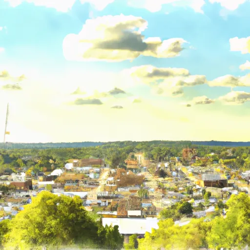
Mount Judea is a small town located in Newton County, Arkansas. Situated in the scenic Ozark Mountains, the town offers a charming rural atmosphere and a pleasant climate. Mount Judea experiences a humid subtropical climate, characterized by hot, humid summers and mild winters. Average temperatures range from the 70s to 90s°F in summer, while winter temperatures usually hover between the 30s and 50s°F.

The region is known for its abundant water resources, with the Buffalo National River flowing nearby. The river provides a variety of outdoor recreation opportunities, including canoeing, kayaking, and fishing. The area also boasts numerous hiking trails, showcasing the picturesque landscapes of the Ozarks, with highlights such as Hemmed-in-Hollow, the tallest waterfall between the Rockies and Appalachians.

Mount Judea is surrounded by natural beauty, with rolling hills, dense forests, and scenic vistas. Visitors can explore the wilderness, spot wildlife, and enjoy camping, picnicking, and photography. The town offers a peaceful retreat for those seeking outdoor adventures and a connection with nature.

What is the Eden Index?

The Snoflo Eden Index serves as a comprehensive rating system for regions, evaluating their desirability through a holistic assessment of climate health, outdoor recreation opportunities, and natural disaster risk, acknowledging the profound impact of these factors on livability and well-being.


Climate Health Indicator (CHI): 8.2


Mount-Judea receives approximately 1184mm of rain per year, with humidity levels near 81% and air temperatures averaging around 15°C. Mount-Judea has a plant hardyness factor of 7, meaning plants and agriculture in this region tend to thrive during the non-winter months. By considering the ideal temperature range, reliable water supplies, clean air, and stable seasonal rain or snowpacks, the Climate Health Indicator (CHI) underscores the significance of a healthy climate as the foundation for quality living.

A healthy climate is paramount for ensuring a high quality of life and livability in a region, fostering both physical well-being and environmental harmony. This can be characterized by ideal temperatures, reliable access to water supplies, clean air, and consistent seasonal rain or snowpacks.


Weather Forecast


Streamflow Conditions

Upper White

Area Rivers

Upper White


Snowpack Depths

Upper White


Reservoir Storage Capacity

Upper White


Groundwater Levels


Recreational Opportunity Index (ROI): 5.6


The Recreational Opportunity Index (ROI) recognizes the value of outdoor recreational options, such as parks, hiking trails, camping sites, and fishing spots, while acknowledging that climate plays a pivotal role in ensuring the comfort and consistency of these experiences. Access to outdoor recreational opportunities, encompassing activities such as parks, hiking, camping, and fishing, is crucial for overall well-being, and the climate plays a pivotal role in enabling and enhancing these experiences, ensuring that individuals can engage in nature-based activities comfortably and consistently.


Camping Areas

Campground Campsites Reservations Toilets Showers Elevation
Stephens - Lake Ouachita 9 420 ft
Bucktail Camp Complex 40 296 ft
Cedar Glades Park None 562 ft
Richland Creek 13 1,034 ft
Petit Jean State Park None 900 ft
Tucker Hollow - Bull Shoals Lake None 697 ft
Logoly State Park None 327 ft
County Line None 359 ft
Drury-Mincy Conservation Area - MDC 4 976 ft
Lake Sylvia 27 704 ft
Lake Claiborne State Park None 337 ft
Ozan Point - De Gray Lake 50 422 ft
Lake Dardanelle State Park None 344 ft
Maxwell Taylor Park None 702 ft
Camp Ridge 91 1,347 ft
Carver - Buffalo National River None 710 ft
Cloud Crossing Complex 13 130 ft
Bennett Spring State Park None 880 ft
Pilot Grove City Park None 845 ft
White Oak Lake State Park None 208 ft
Lake Ouachita State Park None 759 ft
Quarry Cove None 372 ft
Branson City Campground None 704 ft
Lead Hill - Bull Shoals Lake None 678 ft
Riverview - Lake Dardanelle None 363 ft
Bayou Bluff 28 634 ft
Arrow Rock State Park 46 728 ft
Stump Island Park 12 618 ft
River Run None 701 ft
Erbie - Buffalo National River None 847 ft
Lake Catherine State Park None 396 ft
DeGray Lake State Park 113 403 ft
Caddo Drive - De Gray Lake 72 415 ft
Turkey Trot Complex 25 261 ft
Arlie Moore - De Gray Lake 87 517 ft
Herring Memorial Park - Brunswick None 761 ft
Pershing State Park None 691 ft
Ozark - Buffalo National River None 865 ft
Iron Mountain - De Gray Lake 69 456 ft
Lena Landing - Lake Ouachita 10 599 ft
Long Pool 77 615 ft
Gulpha Gorge - Hot Springs National Park 44 540 ft
Cobb Ridge 19 1,360 ft
Edgewood - De Gray Lake 51 409 ft
River Road None 355 ft
Versailles City Park None 990 ft
Shadow Rock Park None 676 ft
Brookfield City Park 15 788 ft

Catastrophe Safeguard Index (CSI):


The Catastrophe Safeguard Index (CSI) recognizes that natural disaster risk, encompassing floods, fires, hurricanes, and tornadoes, can drastically affect safety and the overall appeal of an area. The level of natural disaster risk in a region significantly affects safety and the overall livability, with climate change amplifying these risks by potentially increasing the frequency and intensity of events like floods, fires, hurricanes, and tornadoes, thereby posing substantial challenges to community resilience and well-being.


Community Resilience Indicator (CRI): 0.8


The Community Resilience Indicator (CRI) recognizes that education, healthcare, and socioeconomics are crucial to the well-being of a region. The CRI acknowledges the profound impact of these elements on residents' overall quality of life. By evaluating educational resources, healthcare accessibility, and economic inclusivity, the index captures the essential aspects that contribute to a thriving community, fostering resident satisfaction, equity, and social cohesion.


Log Your Visit

When was your last visit to ?

Add a Photo

How was it? How were conditions?

Rate the


Submit

Leave A Review


Submit

Upload an Image


Favorite Limit Reached