-
Snoflo Premium
Get unlimited access to all our content
With no Ad interruptions! - Start Your Free Trial Login with existing account
Mouth-Of-Wilson
Eden Index
Climate
8.3
•
Recreation
7.3
•
Community
•
Safeguard
5.9/10
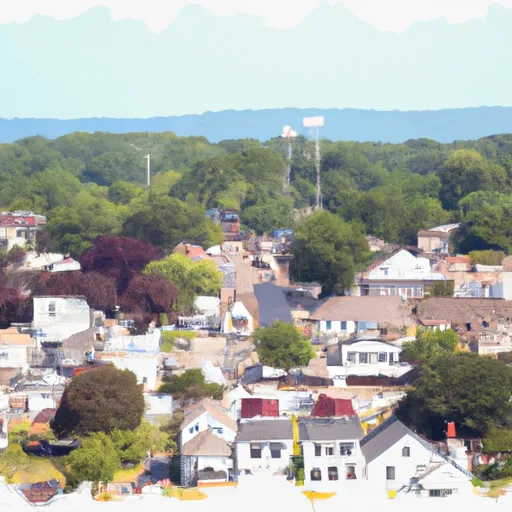
Mouth of Wilson is a small unincorporated community located in Grayson County, Virginia. Situated in the Appalachian Mountains, it offers a picturesque landscape and a serene environment. The climate in Mouth of Wilson is classified as humid subtropical, characterized by warm summers and mild winters. Average temperatures range from the mid-80s°F (30°C) in summer to the mid-30s°F (2°C) in winter.
The community is surrounded by various water sources, including the New River, Big Wilson Creek, and Little Wilson Creek. These waterways provide numerous hydrology constituents, such as diverse aquatic species and lush vegetation. Outdoor enthusiasts can enjoy fishing, kayaking, and canoeing in the New River, which is renowned for its scenic beauty and excellent fishing opportunities.
Mouth of Wilson also offers a variety of outdoor recreational activities. The nearby Grayson Highlands State Park boasts stunning vistas, hiking trails, and camping facilities. Visitors can explore the renowned Mount Rogers National Recreation Area, known for its diverse flora and fauna, extensive trail network, and opportunities for horseback riding. The area's abundant wildlife, including white-tailed deer and wild ponies, adds to the allure of outdoor adventures in Mouth of Wilson.
What is the Eden Index?
The Snoflo Eden Index serves as a comprehensive rating system for regions, evaluating their desirability through a holistic assessment of climate health, outdoor recreation opportunities, and natural disaster risk, acknowledging the profound impact of these factors on livability and well-being.
Climate Health Indicator (CHI): 8.3
Mouth-Of-Wilson receives approximately
1091mm of rain per year,
with humidity levels near 83%
and air temperatures averaging around
11°C.
Mouth-Of-Wilson has a plant hardyness factor of
6, meaning
plants and agriculture in this region thrive during a short period during spring and early summer. Most
plants will die off during the colder winter months.
By considering the ideal temperature range, reliable water supplies, clean air, and stable seasonal rain or snowpacks, the Climate Health Indicator (CHI) underscores the significance of a healthy climate as the foundation for quality living.
A healthy climate is paramount for ensuring a high quality of life and livability in a region, fostering both physical well-being and environmental harmony. This can be characterized by ideal temperatures, reliable access to water supplies, clean air, and consistent seasonal rain or snowpacks.
Weather Forecast
Streamflow Conditions
Kanawha
Area Rivers
Kanawha
Snowpack Depths
Kanawha
Reservoir Storage Capacity
Kanawha
Groundwater Levels
Recreational Opportunity Index (ROI): 7.3
The Recreational Opportunity Index (ROI) recognizes the value of outdoor recreational options, such as parks, hiking trails, camping sites, and fishing spots, while acknowledging that climate plays a pivotal role in ensuring the comfort and consistency of these experiences.
Access to outdoor recreational opportunities, encompassing activities such as parks, hiking, camping, and fishing, is crucial for overall well-being, and the climate plays a pivotal role in enabling and enhancing these experiences, ensuring that individuals can engage in nature-based activities comfortably and consistently.
Camping Areas
Campground | Campsites | Reservations | Toilets | Showers | Elevation |
---|---|---|---|---|---|
Hurricane | 30 | 2,908 ft | |||
Grindstone | 108 | 3,771 ft | |||
Grayson Highlands State Park | None | 4,310 ft | |||
Comers Rock | 6 | 3,807 ft | |||
John H. Moss Lake City Campground | None | 765 ft | |||
Stony Fork | 74 | 2,387 ft | |||
Raccoon Branch | 20 | 2,823 ft | |||
Rural Retreat Lake | 72 | 2,575 ft | |||
Hungry Mother State Park | None | 2,196 ft | |||
Doughton Park - Blue Ridge Parkway | None | 3,692 ft | |||
New River State Park | 20 | 2,730 ft |
Nearby Ski Areas
Catastrophe Safeguard Index (CSI):
The Catastrophe Safeguard Index (CSI) recognizes that natural disaster risk, encompassing floods, fires, hurricanes, and tornadoes, can drastically affect safety and the overall appeal of an area.
The level of natural disaster risk in a region significantly affects safety and the overall livability, with climate change amplifying these risks by potentially increasing the frequency and intensity of events like floods, fires, hurricanes, and tornadoes, thereby posing substantial challenges to community resilience and well-being.
Community Resilience Indicator (CRI):
The Community Resilience Indicator (CRI) recognizes that education, healthcare, and socioeconomics are crucial to the well-being of a region. The CRI acknowledges the profound impact of these elements on residents' overall quality of life. By evaluating educational resources, healthcare accessibility, and economic inclusivity, the index captures the essential aspects that contribute to a thriving community, fostering resident satisfaction, equity, and social cohesion.