

-
 Snoflo Premium
Get unlimited access to all our content
With no Ad interruptions! - Start Your Free Trial Login with existing account
Redding
Eden Index
Climate
10.0
•
Recreation
7.9
•
Community
2.9
•
Safeguard
7.5/10
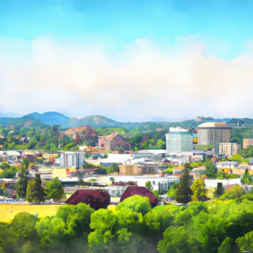
Located in Northern California, Redding is known for its warm climate, diverse hydrology, and abundant outdoor recreational opportunities. The city experiences a Mediterranean climate with hot and dry summers and mild, wet winters. Average temperatures range from 45°F in winter to 95°F in summer, making it an ideal destination for outdoor enthusiasts.
Redding is situated near the Sacramento River and surrounded by stunning natural landscapes, including mountain ranges, lakes, and national forests. The hydrology of the region is dominated by the Sacramento River, which runs through the city and offers opportunities for fishing, boating, and water sports. Shasta Lake, one of the largest reservoirs in California, is a popular destination for water recreation, such as swimming, jet skiing, and sailing.
The area is also home to several national parks, including Lassen Volcanic National Park and Whiskeytown National Recreation Area. These parks provide opportunities for hiking, camping, birdwatching, and exploring volcanic landscapes. With an extensive trail system, Redding is an excellent base for outdoor activities, such as mountain biking, trail running, and horseback riding.
In conclusion, Redding, California, offers a pleasant climate, diverse hydrology, and a multitude of outdoor recreation opportunities, making it a haven for nature lovers and adventure seekers.
What is the Eden Index?
The Snoflo Eden Index serves as a comprehensive rating system for regions, evaluating their desirability through a holistic assessment of climate health, outdoor recreation opportunities, and natural disaster risk, acknowledging the profound impact of these factors on livability and well-being.
Climate Health Indicator (CHI): 10.0
Redding receives approximately
1064mm of rain per year,
with humidity levels near 61%
and air temperatures averaging around
17°C.
Redding has a plant hardyness factor of
9, meaning
plants and agriculture in this region tend to thrive here all year round.
By considering the ideal temperature range, reliable water supplies, clean air, and stable seasonal rain or snowpacks, the Climate Health Indicator (CHI) underscores the significance of a healthy climate as the foundation for quality living.
A healthy climate is paramount for ensuring a high quality of life and livability in a region, fostering both physical well-being and environmental harmony. This can be characterized by ideal temperatures, reliable access to water supplies, clean air, and consistent seasonal rain or snowpacks.
Weather Forecast
Streamflow Conditions
Lower Sacramento
Area Rivers
Lower Sacramento
Snowpack Depths
Lower Sacramento
Reservoir Storage Capacity
Lower Sacramento
Groundwater Levels
Recreational Opportunity Index (ROI): 7.9
The Recreational Opportunity Index (ROI) recognizes the value of outdoor recreational options, such as parks, hiking trails, camping sites, and fishing spots, while acknowledging that climate plays a pivotal role in ensuring the comfort and consistency of these experiences.
Access to outdoor recreational opportunities, encompassing activities such as parks, hiking, camping, and fishing, is crucial for overall well-being, and the climate plays a pivotal role in enabling and enhancing these experiences, ensuring that individuals can engage in nature-based activities comfortably and consistently.
Camping Areas
| Campground | Campsites | Reservations | Toilets | Showers | Elevation |
|---|---|---|---|---|---|
| Jones Valley (Upper) | 8 | 1,094 ft | |||
| Beehive Point - dispersed | None | 1,083 ft | |||
| Brandy Creek RV | 2 | 1,224 ft | |||
| Bailey Cove | 9 | 1,087 ft | |||
| Jones Valley (Lower) | 16 | 1,149 ft | |||
| Greens Creek | 7 | 1,165 ft | |||
| Shasta (OHV) | 23 | 627 ft | |||
| Hirz Bay | 58 | 1,114 ft | |||
| Nelson Point | 9 | 1,091 ft | |||
| Lower Salt Creek - Dispersed | None | 1,045 ft |
Nearby Fishing
Nearby Ski Areas
Catastrophe Safeguard Index (CSI):
The Catastrophe Safeguard Index (CSI) recognizes that natural disaster risk, encompassing floods, fires, hurricanes, and tornadoes, can drastically affect safety and the overall appeal of an area.
The level of natural disaster risk in a region significantly affects safety and the overall livability, with climate change amplifying these risks by potentially increasing the frequency and intensity of events like floods, fires, hurricanes, and tornadoes, thereby posing substantial challenges to community resilience and well-being.
Community Resilience Indicator (CRI): 2.9
The Community Resilience Indicator (CRI) recognizes that education, healthcare, and socioeconomics are crucial to the well-being of a region. The CRI acknowledges the profound impact of these elements on residents' overall quality of life. By evaluating educational resources, healthcare accessibility, and economic inclusivity, the index captures the essential aspects that contribute to a thriving community, fostering resident satisfaction, equity, and social cohesion.