Eastern Boundary Of Park (Original Park Boundary) To Western Boundary Of Park (Original Park Boundary) River Run
Community Reviews
Been here? Share the conditions.
Reviews, ratings & photos are added in the free Snoflo iOS app — rate a spot, tag the conditions, and your visit is verified by location. Add or manage your reviews from the app.
Eastern Boundary Of Park (Original Park Boundary) To Western Boundary Of Park (Original Park Boundary)
The Whitewater River Run is regulated by the National Park Service, and visitors must obtain a permit to enter the area. Visitors are also required to follow specific regulations, such as packing out all trash, using existing campgrounds, and avoiding damage to natural resources. Additionally, visitors are required to carry a portable toilet and use it at all times to prevent contamination of the river.
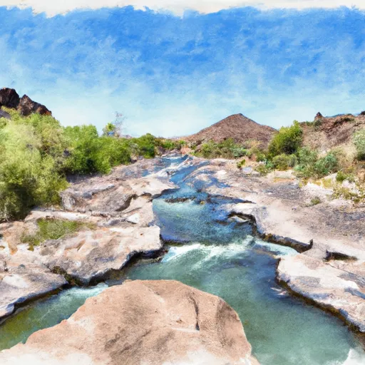
This section of the river is known for its stunning scenery, with towering red rock walls and crystal-clear water. However, visitors should be aware of the potential hazards, such as swift currents, cold water temperatures, and dangerous rapids. It is recommended that visitors have prior whitewater experience and proper safety equipment before attempting this run.
Plan your run down to the hour
Same weather feed Snoflo's iOS app uses -- updated continuously from NOAA / yr.no. Watch the precipitation column on the meteogram; rain ahead of a run typically lifts flows 12-48 hours later depending on the basin.
Next 5 days, hour by hour
Temperature line with weather symbols on top, snow + rain accumulation as columns, humidity as a dotted line.
5-day forecast table
Every 3 hours, broken out across temperature, snow, rain, humidity, and wind. Each cell is colour-coded relative to the column min/max.
| Time | Condition | Temp (°F) | Snow (in) | Rain (in) | Humidity (%) | Wind (mps) | Wind dir |
|---|---|---|---|---|---|---|---|
| Loading detailed forecast… | |||||||
15-day temperature & precipitation
Daily temperatures, snow, and rain projected over the next two weeks -- the upstream story that drives next week's flows.
Regional streamflow levels
USGS streamgauges around Eastern Boundary Of Park (Original Park Boundary) To Western Boundary Of Park (Original Park Boundary) -- useful for spotting upstream pulses and gauging which tributary is contributing what.
| Streamgauge | Discharge | View |
|---|---|---|
| Little Colorado River At Woodruff | 182 cfs | → |
| Little Colorado River At Holbrook | 2,320 cfs | → |
| Puerco River Near Chambers | 528 cfs | → |
| Little Colorado River Near Joseph City | 1,450 cfs | → |
| Little Colorado R Blw Zion Res Nr St. Johns | · | → |
| Little Colorado River Ab Zion Res Nr St. Johns | · | → |
Plan a longer trip
The closest boat launches, other paddle runs, and campgrounds so a day on the water can grow into a full weekend.
Other river runs
- 1/4 Mile Below Forest Road 504 Crossing To Forest Boundary In Section 1, T14n, R15e, Gila And Salt River Meridian
- 0.1 Miles Above Diversion At Durfee Crossing To 1/4 Mile Below Forest Road 504 Crossing
- 1/4 Mile Below Chevelon Lake Dam To 0.1 Miles Above Diversion At Durfee Crossing
- South Fork Little Colorado River
- West Fork Little Colorado River
Parks
- Wilderness Area Petrified Forest National
- Petrified Forest National Park
- International Petrified Forest Dinosaur Park
Points of interest
Whitewater safety
- Check the flow before you run
- Use the linked-gauge card and Regional Flow panel above. Class ratings change with flow -- a Class III at low water can become Class IV+ at high water.
- Know your skill ceiling
- Pick runs comfortably below your ceiling. Cold-water and big-water runs raise the consequences of any mistake.
- Wear the right gear
- Helmet, PFD, drysuit / wetsuit when water is below 60°F. Throw bag, knife, and whistle on your person, not in the boat.
- Scout, set safety, and run with a team
- Scout new rapids on foot, set safety with throw bags above the consequence pool, and run with at least one other competent paddler.
- Respect the river
- Strainers, undercuts, low-head dams, and wood can kill at any class rating. When in doubt, portage.
Set push alerts in the Snoflo app
Save Eastern Boundary Of Park (Original Park Boundary) To Western Boundary Of Park (Original Park Boundary) as a favorite, set a discharge threshold (e.g. "alert me when flow hits 600 cfs"), and the iOS app pushes the moment the linked gauge crosses.
About Eastern Boundary Of Park (Original Park Boundary) To Western Boundary Of Park (Original Park Boundary)
What's the optimal flow for Eastern Boundary Of Park (Original Park Boundary) To Western Boundary Of Park (Original Park Boundary)?
The optimal flow depends on the section and the craft. Check the Run Details panel for the linked gauge and current status.
How fresh is the cfs reading on this page?
The linked USGS streamgauge reports continuously (every 15 minutes); Snoflo refreshes throughout the day. Hover the streamflow sparkline to read individual datapoints.
What's the whitewater class?
See the Run Details panel for the class rating Snoflo tracks for this run. Class ratings change with flow -- a Class III at low water can become Class IV in high water.
Where do I put in / take out?
Tap Directions in the hero above to open driving directions to the put-in. For shuttle planning, check the Nearby Boat Launches panel and the river run operator's site.
Can I get alerts when flows hit the optimal range?
Yes -- alerts are managed in the Snoflo iOS app. Favorite this run, set a discharge threshold, and you'll get a push the moment the gauge crosses.
Other runs near here
Snoflo-tracked paddle runs within driving distance of Eastern Boundary Of Park (Original Park Boundary) To Western Boundary Of Park (Original Park Boundary).