Begins 1.5 Miles Upstream From Confluence With The Colorado River To Confluence With The Colorado River River Run
Community Reviews
Been here? Share the conditions.
Reviews, ratings & photos are added in the free Snoflo iOS app — rate a spot, tag the conditions, and your visit is verified by location. Add or manage your reviews from the app.
Begins 1.5 Miles Upstream From Confluence With The Colorado River To Confluence With The Colorado River
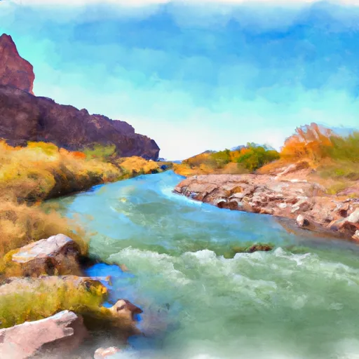
During the run, paddlers will encounter several rapids and obstacles that require skillful navigation. Some of the most notable rapids include House Rock Rapid, Hance Rapids, and Granite Rapid. These rapids are known for their strong currents, steep drops, and large waves. Paddlers must be aware of the potential hazards and take appropriate safety precautions.
To ensure the safety of paddlers and preserve the natural environment, there are specific regulations to the area. All paddlers must have a permit to run the river, and the number of permits issued is limited to protect the ecosystem. Additionally, paddlers must follow Leave No Trace principles to minimize their impact on the environment.
In conclusion, the Whitewater River Run is a exciting adventure that requires skill and experience. With an ideal streamflow range between 2,000 and 25,000 cfs, a class rating of III to IV, and several notable rapids and obstacles, this run is not for the faint of heart. To ensure safety and environmental protection, specific regulations must be followed, including obtaining a permit and following Leave No Trace principles.
Plan your run down to the hour
Same weather feed Snoflo's iOS app uses -- updated continuously from NOAA / yr.no. Watch the precipitation column on the meteogram; rain ahead of a run typically lifts flows 12-48 hours later depending on the basin.
Next 5 days, hour by hour
Temperature line with weather symbols on top, snow + rain accumulation as columns, humidity as a dotted line.
5-day forecast table
Every 3 hours, broken out across temperature, snow, rain, humidity, and wind. Each cell is colour-coded relative to the column min/max.
| Time | Condition | Temp (°F) | Snow (in) | Rain (in) | Humidity (%) | Wind (mps) | Wind dir |
|---|---|---|---|---|---|---|---|
| Loading detailed forecast… | |||||||
15-day temperature & precipitation
Daily temperatures, snow, and rain projected over the next two weeks -- the upstream story that drives next week's flows.
Regional streamflow levels
USGS streamgauges around Begins 1.5 Miles Upstream From Confluence With The Colorado River To Confluence With The Colorado River -- useful for spotting upstream pulses and gauging which tributary is contributing what.
| Streamgauge | Discharge | View |
|---|---|---|
| Kanab Creek Abv Mouth Nr Supai | 55 cfs | → |
| Havasu Creek Abv Mouth Nr Supai | 76 cfs | → |
| Havasu Creek At Supai | 76 cfs | → |
| Colorado River Near Grand Canyon | 8,060 cfs | → |
| Little Colorado River Abv Mouth Nr Desert View | 655 cfs | → |
| Kanab Creek Near Kanab | 4 cfs | → |
Plan a longer trip
The closest boat launches, other paddle runs, and campgrounds so a day on the water can grow into a full weekend.
Other river runs
- Confluence With Kanab Creek To Spencer Canyon
- Begins 2 Miles Upstream From Confluence With The Colorado River To Confluence With The Colorado River
- Deer Spring To Confluence With The Colorado River
- Southern Boundary Of Grand Canyon National Park To Confluence With The Colorado River
- Southern Border Of The Kaibab Paiute Indian Reservation To Confluence With The Colorado River
Whitewater safety
- Check the flow before you run
- Use the linked-gauge card and Regional Flow panel above. Class ratings change with flow -- a Class III at low water can become Class IV+ at high water.
- Know your skill ceiling
- Pick runs comfortably below your ceiling. Cold-water and big-water runs raise the consequences of any mistake.
- Wear the right gear
- Helmet, PFD, drysuit / wetsuit when water is below 60°F. Throw bag, knife, and whistle on your person, not in the boat.
- Scout, set safety, and run with a team
- Scout new rapids on foot, set safety with throw bags above the consequence pool, and run with at least one other competent paddler.
- Respect the river
- Strainers, undercuts, low-head dams, and wood can kill at any class rating. When in doubt, portage.
Set push alerts in the Snoflo app
Save Begins 1.5 Miles Upstream From Confluence With The Colorado River To Confluence With The Colorado River as a favorite, set a discharge threshold (e.g. "alert me when flow hits 600 cfs"), and the iOS app pushes the moment the linked gauge crosses.
About Begins 1.5 Miles Upstream From Confluence With The Colorado River To Confluence With The Colorado River
What's the optimal flow for Begins 1.5 Miles Upstream From Confluence With The Colorado River To Confluence With The Colorado River?
The optimal flow depends on the section and the craft. Check the Run Details panel for the linked gauge and current status.
How fresh is the cfs reading on this page?
The linked USGS streamgauge reports continuously (every 15 minutes); Snoflo refreshes throughout the day. Hover the streamflow sparkline to read individual datapoints.
What's the whitewater class?
See the Run Details panel for the class rating Snoflo tracks for this run. Class ratings change with flow -- a Class III at low water can become Class IV in high water.
Where do I put in / take out?
Tap Directions in the hero above to open driving directions to the put-in. For shuttle planning, check the Nearby Boat Launches panel and the river run operator's site.
Can I get alerts when flows hit the optimal range?
Yes -- alerts are managed in the Snoflo iOS app. Favorite this run, set a discharge threshold, and you'll get a push the moment the gauge crosses.
Other runs near here
Snoflo-tracked paddle runs within driving distance of Begins 1.5 Miles Upstream From Confluence With The Colorado River To Confluence With The Colorado River.