Little Colorado River fishing
As of July 15, 2026, the nearest streamgauge to Little Colorado River — Little Colorado River Abv Mouth Nr Desert View — reports 215 cfs. Source: USGS gauge data, refreshed throughout the day.
Community Reviews
Been here? Share the conditions.
Reviews, ratings & photos are added in the free Snoflo iOS app — rate a spot, tag the conditions, and your visit is verified by location. Add or manage your reviews from the app.
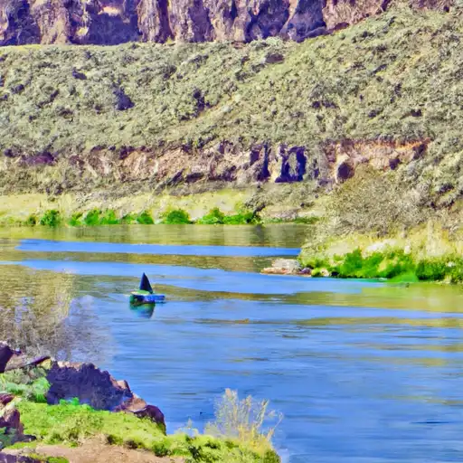
Little Colorado River
What's biting at Little Colorado River
Species commonly reported here -- tap any card for techniques, target seasons, and other waters where it's been caught.
Plan your trip down to the hour
Same weather feed Snoflo's iOS app uses -- updated continuously from NOAA / yr.no.
Next 5 days, hour by hour
Temperature line with weather symbols on top, snow + rain accumulation as columns, humidity as a dotted line.
5-day forecast table
Every 3 hours, broken out across temperature, snow, rain, humidity, and wind. Each cell is colour-coded relative to the column min/max so trends jump out at a glance.
| Time | Condition | Temp (°F) | Snow (in) | Rain (in) | Humidity (%) | Wind (mps) | Wind dir |
|---|---|---|---|---|---|---|---|
| Loading detailed forecast… | |||||||
15-day temperature & precipitation
Daily temperatures, snow, and rain projected over the next two weeks. Hover any point for the full breakdown.
Nearby streamflow
USGS streamgauges within reach of Little Colorado River -- updated continuously from the National Water Information System.
| Streamgauge | Discharge | View |
|---|---|---|
| Little Colorado River Abv Mouth Nr Desert View | 215 cfs | → |
| Colorado River Near Grand Canyon | 8,080 cfs | → |
| Little Colorado River Near Cameron | · | → |
| Moenkopi Wash At Moenkopi | · | → |
| Colorado River At Lees Ferry | 9,060 cfs | → |
| Kanab Creek Abv Mouth Nr Supai | 5 cfs | → |
Plan a longer trip
The closest campgrounds, parks, boat launches, and reservoirs so a fishing run can grow into a weekend.
Campgrounds
Reservoirs
- Russell Tank Dam
- Pasture Canyon
- Tom Tank
- Page Effluent Ponds 2a & 2b
- Glen Canyon
- Navajo Evap Pond 60-2
Boat launches
- Pasture Canyon Lake
- Antelope Point Marina Access Coconino County
- Antelope Point Boat Launch Coconino County
- Wahweap - 1
- Stateline Launch Ramp Kane County
Points of interest
- United Air Lines Flight 718 Douglas Dc-7 (N6324c)
- Twa Flight 2 Lockheed L-1049 (N6902c)
- Hartman Natural Bridge
- Roosevelt Trailhead
- Natural Arch
- Angels Window
Paddle runs
- The Border Of Np Land And Navajo & Hopi Tribal Lands. To Confluence With The Colorado River
- Eastern Edge Of Kwagunt Valley (Past The Butte Fault) To Confluence With The Colorado River
- First Major North Arm Of Lava Creek At The Base Of Chiavria Point To Confluence With The Colorado River
- Begins Just Over 1 Mile Beyond Where The Nankoweap Trails Leaves The Creek And Heads Off To The North. To Confluence With The Colorado River
- Confluence With Nankoweap Creek To Red Canyon And The Beginning Of Upper Granite Gorge
- Cheyava Falls To Confluence With The Colorado River
Angling safety & ethics
- Know the regulations
- Check local fishing rules, seasons, size limits, and license requirements to ensure legal and sustainable angling.
- Handle fish responsibly
- Use wet hands, minimize air exposure, and release fish gently to improve survival rates when practicing catch-and-release.
- Choose the right gear
- Match your rod, line, and tackle to the species and conditions to increase success and reduce unnecessary harm to fish.
- Respect the waterway
- Avoid disturbing habitat, prevent bank erosion, and keep a safe distance from spawning areas to protect ecosystems.
- Keep it clean
- Pack out all line, hooks, bait containers, and trash. Discarded gear can injure wildlife and degrade waterways.
Set push alerts in the Snoflo app
Save Little Colorado River as a favorite, set a custom threshold (water temperature, streamflow, snowpack), and the iOS app will push the moment conditions cross.
About Little Colorado River
What fish species are found at Little Colorado River?
Snoflo tracks the species commonly reported at Little Colorado River -- see the Fish Species panel above for the live list with images and links to per-species pages.
How fresh is the weather data on this page?
The hourly forecast updates throughout the day from the NOAA / yr.no public feeds. Streamflow data comes live from USGS streamgauges, also refreshed continuously.
Can I get alerts when conditions change?
Yes -- alerts are managed through the Snoflo iOS app. Favorite this area, set a threshold (water temperature, streamflow, snowpack), and you'll get a push the moment it crosses.
Do I need a fishing license?
Yes. Check your state agency's regulations for license requirements, seasons, size limits, and any waterbody-specific rules before fishing Little Colorado River.
How do I get to Little Colorado River?
Tap Open in map in the hero above to center the Snoflo interactive map on this area, or grab the coordinates from the location facts panel.
Other angling spots near here
Snoflo-tracked fishing areas within driving distance of Little Colorado River.