Approximately 9 Miles Below The Headwaters At The West Boundary Of East Verde Park Estates To West Boundary Of L.F. Ranch River Run
Community Reviews
Been here? Share the conditions.
Reviews, ratings & photos are added in the free Snoflo iOS app — rate a spot, tag the conditions, and your visit is verified by location. Add or manage your reviews from the app.
Approximately 9 Miles Below The Headwaters At The West Boundary Of East Verde Park Estates To West Boundary Of L.F. Ranch
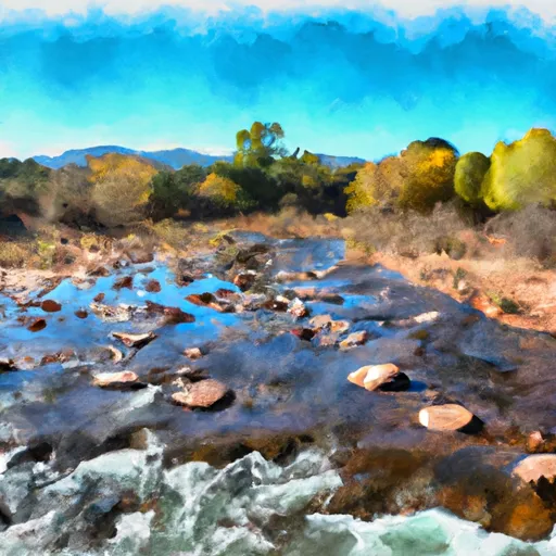
The segment mileage for this run is approximately 9 miles, starting from the West Boundary of East Verde Park Estates and ending at the West Boundary of L.F. Ranch. The river features several rapids and obstacles, including the "Boulder Drop," "Pinball," and "House Rock." These rapids provide an exciting challenge for experienced paddlers.
It is important to note that the Whitewater River Run is located within a designated wilderness area, and therefore specific regulations apply. Visitors are advised to obtain a permit before accessing the river, and all gear and equipment must be carried in and out of the area. Additionally, fires are not permitted, and visitors are expected to practice Leave No Trace principles to protect the natural environment.
Overall, the Whitewater River Run is an exciting and challenging destination for experienced paddlers. Visitors are encouraged to check current streamflow conditions and obtain all necessary permits and information before embarking on this adventure.
Plan your run down to the hour
Same weather feed Snoflo's iOS app uses -- updated continuously from NOAA / yr.no. Watch the precipitation column on the meteogram; rain ahead of a run typically lifts flows 12-48 hours later depending on the basin.
Next 5 days, hour by hour
Temperature line with weather symbols on top, snow + rain accumulation as columns, humidity as a dotted line.
5-day forecast table
Every 3 hours, broken out across temperature, snow, rain, humidity, and wind. Each cell is colour-coded relative to the column min/max.
| Time | Condition | Temp (°F) | Snow (in) | Rain (in) | Humidity (%) | Wind (mps) | Wind dir |
|---|---|---|---|---|---|---|---|
| Loading detailed forecast… | |||||||
15-day temperature & precipitation
Daily temperatures, snow, and rain projected over the next two weeks -- the upstream story that drives next week's flows.
Regional streamflow levels
USGS streamgauges around Approximately 9 Miles Below The Headwaters At The West Boundary Of East Verde Park Estates To West Boundary Of L.F. Ranch -- useful for spotting upstream pulses and gauging which tributary is contributing what.
| Streamgauge | Discharge | View |
|---|---|---|
| East Verde R Div From East Clear Cr Nr Pine | 3 cfs | → |
| East Verde River Near Childs | 0 cfs | → |
| Wet Bottom Creek Near Childs | 1 cfs | → |
| Tonto Creek Abv Gun Creek | 9 cfs | → |
| West Clear Creek Near Camp Verde | 14 cfs | → |
| Verde R Blw Tangle Creek | 156 cfs | → |
Plan a longer trip
The closest boat launches, other paddle runs, and campgrounds so a day on the water can grow into a full weekend.
Other river runs
- West Boundary Of L.F. Ranch To Verde Wild And Scenic River
- Below Flow Structure In Sec 16, T12n,R11e To Confluence With Clear Creek
- Hell's Gate Canyon
- Headwaters In Sec 14, T13n, R9e To Clear Creek Wilderness Boundary
- Confluence With Cocomunga Creek To Confluence With Gun Creek
Campgrounds
- Flowing Springs
- Flowing Springs Dispersed
- Houston Mesa
- Houston Mesa Campground
- Houston Mesa Campground And Equestrian Sites
- Payson Campground & Rv Resort
Fishing spots
Parks
Whitewater safety
- Check the flow before you run
- Use the linked-gauge card and Regional Flow panel above. Class ratings change with flow -- a Class III at low water can become Class IV+ at high water.
- Know your skill ceiling
- Pick runs comfortably below your ceiling. Cold-water and big-water runs raise the consequences of any mistake.
- Wear the right gear
- Helmet, PFD, drysuit / wetsuit when water is below 60°F. Throw bag, knife, and whistle on your person, not in the boat.
- Scout, set safety, and run with a team
- Scout new rapids on foot, set safety with throw bags above the consequence pool, and run with at least one other competent paddler.
- Respect the river
- Strainers, undercuts, low-head dams, and wood can kill at any class rating. When in doubt, portage.
Set push alerts in the Snoflo app
Save Approximately 9 Miles Below The Headwaters At The West Boundary Of East Verde Park Estates To West Boundary Of L.F. Ranch as a favorite, set a discharge threshold (e.g. "alert me when flow hits 600 cfs"), and the iOS app pushes the moment the linked gauge crosses.
About Approximately 9 Miles Below The Headwaters At The West Boundary Of East Verde Park Estates To West Boundary Of L.F. Ranch
What's the optimal flow for Approximately 9 Miles Below The Headwaters At The West Boundary Of East Verde Park Estates To West Boundary Of L.F. Ranch?
The optimal flow depends on the section and the craft. Check the Run Details panel for the linked gauge and current status.
How fresh is the cfs reading on this page?
The linked USGS streamgauge reports continuously (every 15 minutes); Snoflo refreshes throughout the day. Hover the streamflow sparkline to read individual datapoints.
What's the whitewater class?
See the Run Details panel for the class rating Snoflo tracks for this run. Class ratings change with flow -- a Class III at low water can become Class IV in high water.
Where do I put in / take out?
Tap Directions in the hero above to open driving directions to the put-in. For shuttle planning, check the Nearby Boat Launches panel and the river run operator's site.
Can I get alerts when flows hit the optimal range?
Yes -- alerts are managed in the Snoflo iOS app. Favorite this run, set a discharge threshold, and you'll get a push the moment the gauge crosses.
Other runs near here
Snoflo-tracked paddle runs within driving distance of Approximately 9 Miles Below The Headwaters At The West Boundary Of East Verde Park Estates To West Boundary Of L.F. Ranch.