Bwcaw Boundary To Confluence With Plouff Creek River Run
Community Reviews
Been here? Share the conditions.
Reviews, ratings & photos are added in the free Snoflo iOS app — rate a spot, tag the conditions, and your visit is verified by location. Add or manage your reviews from the app.
Bwcaw Boundary To Confluence With Plouff Creek
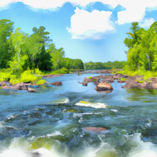
Some notable rapids and obstacles on this run include the "Little Falls" rapid, which is a steep drop with a rocky landing, and the "Horseshoe" rapid, which features a sharp turn and a narrow channel. It is important to note that there are specific regulations for the BWCAB area, including obtaining a permit to enter the wilderness and following all Leave No Trace principles to preserve the environment.
Overall, the Whitewater River Run is a challenging and exciting destination for experienced paddlers. It is important to check the streamflow levels before embarking on this trip, as low water levels can make the rapids more dangerous and difficult to navigate. By following regulations and respecting the natural environment, visitors can enjoy this beautiful and thrilling river run.
Plan your run down to the hour
Same weather feed Snoflo's iOS app uses -- updated continuously from NOAA / yr.no. Watch the precipitation column on the meteogram; rain ahead of a run typically lifts flows 12-48 hours later depending on the basin.
Next 5 days, hour by hour
Temperature line with weather symbols on top, snow + rain accumulation as columns, humidity as a dotted line.
5-day forecast table
Every 3 hours, broken out across temperature, snow, rain, humidity, and wind. Each cell is colour-coded relative to the column min/max.
| Time | Condition | Temp (°F) | Snow (in) | Rain (in) | Humidity (%) | Wind (mps) | Wind dir |
|---|---|---|---|---|---|---|---|
| Loading detailed forecast… | |||||||
15-day temperature & precipitation
Daily temperatures, snow, and rain projected over the next two weeks -- the upstream story that drives next week's flows.
Regional streamflow levels
USGS streamgauges around Bwcaw Boundary To Confluence With Plouff Creek -- useful for spotting upstream pulses and gauging which tributary is contributing what.
| Streamgauge | Discharge | View |
|---|---|---|
| Kawishiwi River Near Ely | 49 cfs | → |
| South Kawishiwi River Near Ely | 84 cfs | → |
| Basswood River Near Winton | 395 cfs | → |
| South Kawishiwi R Abv White Iron Lake Nr Ely | 101 cfs | → |
| Pigeon River At Middle Falls Nr Grand Portage Mn | 151 cfs | → |
| Knife River Near Two Harbors | 4 cfs | → |
Plan a longer trip
The closest boat launches, other paddle runs, and campgrounds so a day on the water can grow into a full weekend.
Boat launches
Other river runs
- North Temperance Lake In T63n, R4w To Bwcaw Boundary In T62n, R4w
- Confluence With Plouff Creek To Lake Superior In T59n, R4w
- Horshoe Lake In T64n, R1w To Bwcaw Boundary
- Bwcaw Boundary To Forest Boundary In T62n, R2e
- Forest Boundary To Lake Superior In T62n, R3e
Campgrounds
- Rice Lake
- Temperance River
- Temperance River National Forest Campground
- Temperance River Campground
- Poplar River Campground
- Poplar River Rustic Campground
Parks
Whitewater safety
- Check the flow before you run
- Use the linked-gauge card and Regional Flow panel above. Class ratings change with flow -- a Class III at low water can become Class IV+ at high water.
- Know your skill ceiling
- Pick runs comfortably below your ceiling. Cold-water and big-water runs raise the consequences of any mistake.
- Wear the right gear
- Helmet, PFD, drysuit / wetsuit when water is below 60°F. Throw bag, knife, and whistle on your person, not in the boat.
- Scout, set safety, and run with a team
- Scout new rapids on foot, set safety with throw bags above the consequence pool, and run with at least one other competent paddler.
- Respect the river
- Strainers, undercuts, low-head dams, and wood can kill at any class rating. When in doubt, portage.
Set push alerts in the Snoflo app
Save Bwcaw Boundary To Confluence With Plouff Creek as a favorite, set a discharge threshold (e.g. "alert me when flow hits 600 cfs"), and the iOS app pushes the moment the linked gauge crosses.
About Bwcaw Boundary To Confluence With Plouff Creek
What's the optimal flow for Bwcaw Boundary To Confluence With Plouff Creek?
The optimal flow depends on the section and the craft. Check the Run Details panel for the linked gauge and current status.
How fresh is the cfs reading on this page?
The linked USGS streamgauge reports continuously (every 15 minutes); Snoflo refreshes throughout the day. Hover the streamflow sparkline to read individual datapoints.
What's the whitewater class?
See the Run Details panel for the class rating Snoflo tracks for this run. Class ratings change with flow -- a Class III at low water can become Class IV in high water.
Where do I put in / take out?
Tap Directions in the hero above to open driving directions to the put-in. For shuttle planning, check the Nearby Boat Launches panel and the river run operator's site.
Can I get alerts when flows hit the optimal range?
Yes -- alerts are managed in the Snoflo iOS app. Favorite this run, set a discharge threshold, and you'll get a push the moment the gauge crosses.
Other runs near here
Snoflo-tracked paddle runs within driving distance of Bwcaw Boundary To Confluence With Plouff Creek.