Sounthern Boundary Of Redwood National And State Parks To Northern Boundary Of Redwood National And State Parks River Run
Community Reviews
Been here? Share the conditions.
Reviews, ratings & photos are added in the free Snoflo iOS app — rate a spot, tag the conditions, and your visit is verified by location. Add or manage your reviews from the app.
Sounthern Boundary Of Redwood National And State Parks To Northern Boundary Of Redwood National And State Parks
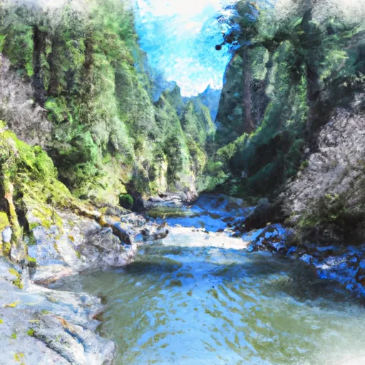
The run is broken into three segments, with the first segment covering 7 miles from Bear Creek to Simpson-Reed Trailhead. This segment is the most difficult, with class IV and V rapids, including "Steep Creek Falls" and "Horseshoe Falls." The second segment covers 10 miles from Simpson-Reed Trailhead to Klamath Glen, with class III and IV rapids. The final segment covers 4 miles from Klamath Glen to the Pacific Ocean, with mostly class II and III rapids.
The Whitewater River Run is subject to specific regulations, including the requirement for all boaters to wear a personal flotation device at all times while on the river. Additionally, the use of alcohol or drugs is strictly prohibited while on the water. Due to the remote nature of the run, it is recommended that all boaters have experience and proper equipment, including a first aid kit and emergency communication device.
Overall, the Whitewater River Run offers a thrilling and challenging rafting experience for experienced boaters, with stunning views of the redwood forests along the way. However, it is important to be prepared and follow all regulations to ensure a safe trip.
Plan your run down to the hour
Same weather feed Snoflo's iOS app uses -- updated continuously from NOAA / yr.no. Watch the precipitation column on the meteogram; rain ahead of a run typically lifts flows 12-48 hours later depending on the basin.
Next 5 days, hour by hour
Temperature line with weather symbols on top, snow + rain accumulation as columns, humidity as a dotted line.
5-day forecast table
Every 3 hours, broken out across temperature, snow, rain, humidity, and wind. Each cell is colour-coded relative to the column min/max.
| Time | Condition | Temp (°F) | Snow (in) | Rain (in) | Humidity (%) | Wind (mps) | Wind dir |
|---|---|---|---|---|---|---|---|
| Loading detailed forecast… | |||||||
15-day temperature & precipitation
Daily temperatures, snow, and rain projected over the next two weeks -- the upstream story that drives next week's flows.
Regional streamflow levels
USGS streamgauges around Sounthern Boundary Of Redwood National And State Parks To Northern Boundary Of Redwood National And State Parks -- useful for spotting upstream pulses and gauging which tributary is contributing what.
| Streamgauge | Discharge | View |
|---|---|---|
| Little R Nr Trinidad Ca | 6 cfs | → |
| Trinity R A Hoopa Ca | 714 cfs | → |
| Redwood C A Orick Ca | 46 cfs | → |
| Redwood C Nr Blue Lake Ca | 7 cfs | → |
| Mad R Nr Arcata Ca | 50 cfs | → |
| Klamath R A Orleans | 1,000 cfs | → |
Plan a longer trip
The closest boat launches, other paddle runs, and campgrounds so a day on the water can grow into a full weekend.
Boat launches
- Big Lagoon Boat Ramp Humboldt County
- Humboldt Lagoons State Park
- Trinidad Wharf, Trinidad
- Redwood Highway, Trinidad
- Mad River County Park Mckinleyville
Other river runs
- Lacks Creek
- Nw 1/4 Sec 23, T14n, R4e To Near Center Of Sec 3, T12n, R3e
- Headwaters To Confluence With New River
- From The Reserve Boundary Just Downstream Of The Elk River Trailhead In Sec. 35 T4n, R1w, Humboldt Meridian (H.M.) To To The Old Town Site At Falk In Sec. 36, T4n, R1w, H.M.
- Mad River (Segment 1)
Campgrounds
Whitewater safety
- Check the flow before you run
- Use the linked-gauge card and Regional Flow panel above. Class ratings change with flow -- a Class III at low water can become Class IV+ at high water.
- Know your skill ceiling
- Pick runs comfortably below your ceiling. Cold-water and big-water runs raise the consequences of any mistake.
- Wear the right gear
- Helmet, PFD, drysuit / wetsuit when water is below 60°F. Throw bag, knife, and whistle on your person, not in the boat.
- Scout, set safety, and run with a team
- Scout new rapids on foot, set safety with throw bags above the consequence pool, and run with at least one other competent paddler.
- Respect the river
- Strainers, undercuts, low-head dams, and wood can kill at any class rating. When in doubt, portage.
Set push alerts in the Snoflo app
Save Sounthern Boundary Of Redwood National And State Parks To Northern Boundary Of Redwood National And State Parks as a favorite, set a discharge threshold (e.g. "alert me when flow hits 600 cfs"), and the iOS app pushes the moment the linked gauge crosses.
About Sounthern Boundary Of Redwood National And State Parks To Northern Boundary Of Redwood National And State Parks
What's the optimal flow for Sounthern Boundary Of Redwood National And State Parks To Northern Boundary Of Redwood National And State Parks?
The optimal flow depends on the section and the craft. Check the Run Details panel for the linked gauge and current status.
How fresh is the cfs reading on this page?
The linked USGS streamgauge reports continuously (every 15 minutes); Snoflo refreshes throughout the day. Hover the streamflow sparkline to read individual datapoints.
What's the whitewater class?
See the Run Details panel for the class rating Snoflo tracks for this run. Class ratings change with flow -- a Class III at low water can become Class IV in high water.
Where do I put in / take out?
Tap Directions in the hero above to open driving directions to the put-in. For shuttle planning, check the Nearby Boat Launches panel and the river run operator's site.
Can I get alerts when flows hit the optimal range?
Yes -- alerts are managed in the Snoflo iOS app. Favorite this run, set a discharge threshold, and you'll get a push the moment the gauge crosses.
Other runs near here
Snoflo-tracked paddle runs within driving distance of Sounthern Boundary Of Redwood National And State Parks To Northern Boundary Of Redwood National And State Parks.