North Fork Cedar Creek river run
Community Reviews
Been here? Share the conditions.
Reviews, ratings & photos are added in the free Snoflo iOS app — rate a spot, tag the conditions, and your visit is verified by location. Add or manage your reviews from the app.
North Fork Cedar Creek
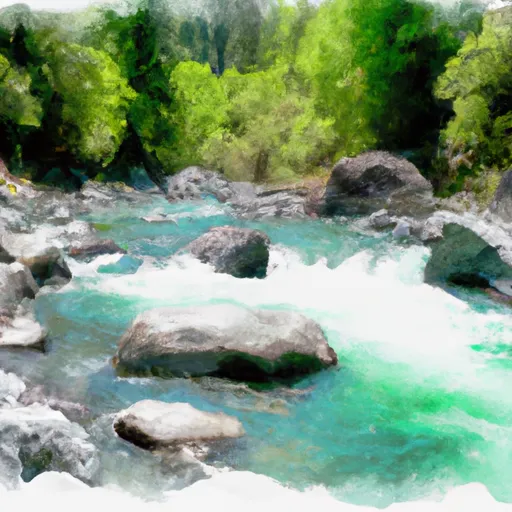
This river run is known for its technical rapids and obstacles, including the "Toilet Bowl" and "Three Pins." The "Toilet Bowl" is a steep and narrow drop with a large recirculating hole at the bottom, while the "Three Pins" is a series of three steep drops with tight channels that require precise navigation.
It is important to note that this river run is only suitable for experienced whitewater kayakers and rafters. Additionally, the area is regulated by the US Forest Service, which requires all boaters to obtain a permit before using the river. The permit system is used to limit the number of boaters on the river and to protect the natural resources in the area.
In summary, the North Fork Cedar Creek is a challenging whitewater river run located in Northern California. With a narrow streamflow range of 400-800 cfs, this Class V river is known for its technical rapids and obstacles, including the "Toilet Bowl" and "Three Pins." Boaters must obtain a permit from the US Forest Service and have significant experience to safely navigate this segment of the river.
Plan your run down to the hour
Same weather feed Snoflo's iOS app uses -- updated continuously from NOAA / yr.no. Watch the precipitation column on the meteogram; rain ahead of a run typically lifts flows 12-48 hours later depending on the basin.
Next 5 days, hour by hour
Temperature line with weather symbols on top, snow + rain accumulation as columns, humidity as a dotted line.
5-day forecast table
Every 3 hours, broken out across temperature, snow, rain, humidity, and wind. Each cell is colour-coded relative to the column min/max.
| Time | Condition | Temp (°F) | Snow (in) | Rain (in) | Humidity (%) | Wind (mps) | Wind dir |
|---|---|---|---|---|---|---|---|
| Loading detailed forecast… | |||||||
15-day temperature & precipitation
Daily temperatures, snow, and rain projected over the next two weeks -- the upstream story that drives next week's flows.
Regional streamflow levels
USGS streamgauges around North Fork Cedar Creek -- useful for spotting upstream pulses and gauging which tributary is contributing what.
| Streamgauge | Discharge | View |
|---|---|---|
| Sf Eel R A Leggett Ca | 33 cfs | → |
| Elder C Nr Branscomb Ca | 1 cfs | → |
| Sf Eel R Nr Miranda Ca | 48 cfs | → |
| Mf Eel R Nr Dos Rios Ca | 36 cfs | → |
| Eel R A Fort Seward Ca | 76 cfs | → |
| Mattole R Nr Ettersburg Ca | 20 cfs | → |
Plan a longer trip
The closest boat launches, other paddle runs, and campgrounds so a day on the water can grow into a full weekend.
Other river runs
Campgrounds
- Hiker-Biker Campsite - Standish-Hickey
- Redwoods River Resort Campground
- Hike And Bike Campsite
- Richardson Grove Camping
- Dawn Redwood Group Campground
- Hotel Gulch Campsite
Whitewater safety
- Check the flow before you run
- Use the linked-gauge card and Regional Flow panel above. Class ratings change with flow -- a Class III at low water can become Class IV+ at high water.
- Know your skill ceiling
- Pick runs comfortably below your ceiling. Cold-water and big-water runs raise the consequences of any mistake.
- Wear the right gear
- Helmet, PFD, drysuit / wetsuit when water is below 60°F. Throw bag, knife, and whistle on your person, not in the boat.
- Scout, set safety, and run with a team
- Scout new rapids on foot, set safety with throw bags above the consequence pool, and run with at least one other competent paddler.
- Respect the river
- Strainers, undercuts, low-head dams, and wood can kill at any class rating. When in doubt, portage.
Set push alerts in the Snoflo app
Save North Fork Cedar Creek as a favorite, set a discharge threshold (e.g. "alert me when flow hits 600 cfs"), and the iOS app pushes the moment the linked gauge crosses.
About North Fork Cedar Creek
What's the optimal flow for North Fork Cedar Creek?
The optimal flow depends on the section and the craft. Check the Run Details panel for the linked gauge and current status.
How fresh is the cfs reading on this page?
The linked USGS streamgauge reports continuously (every 15 minutes); Snoflo refreshes throughout the day. Hover the streamflow sparkline to read individual datapoints.
What's the whitewater class?
See the Run Details panel for the class rating Snoflo tracks for this run. Class ratings change with flow -- a Class III at low water can become Class IV in high water.
Where do I put in / take out?
Tap Directions in the hero above to open driving directions to the put-in. For shuttle planning, check the Nearby Boat Launches panel and the river run operator's site.
Can I get alerts when flows hit the optimal range?
Yes -- alerts are managed in the Snoflo iOS app. Favorite this run, set a discharge threshold, and you'll get a push the moment the gauge crosses.
Other runs near here
Snoflo-tracked paddle runs within driving distance of North Fork Cedar Creek.