Rattlesnake Creek River Run
Community Reviews
Been here? Share the conditions.
Reviews, ratings & photos are added in the free Snoflo iOS app — rate a spot, tag the conditions, and your visit is verified by location. Add or manage your reviews from the app.
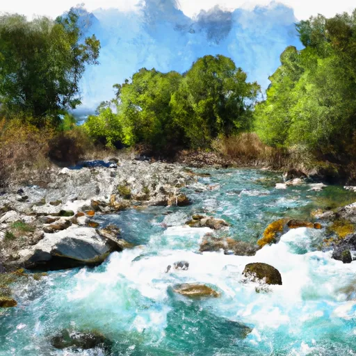
Rattlesnake Creek
Rattlesnake Creek is a tributary of the North Fork American River in the state of California. It is a popular whitewater run for experienced kayakers and rafters, with a class rating of III-IV. The ideal streamflow range for Rattlesnake Creek is between 300 and 800 cubic feet per second (cfs), which typically occurs during the spring months when snowmelt is at its peak.
The segment mileage of Rattlesnake Creek is approximately 6 miles, starting at the confluence with the North Fork American River and ending at the Rattlesnake Bar Bridge. The run features a number of challenging rapids and obstacles, including Rattlesnake, Bouncing Rock, and S-Turn.
There are a number of specific regulations in place for the Rattlesnake Creek area. For example, visitors are required to obtain a permit from the Bureau of Land Management before accessing the put-in and take-out points. Additionally, visitors are required to pack out all trash and leave no trace.
Plan your run down to the hour
Same weather feed Snoflo's iOS app uses -- updated continuously from NOAA / yr.no. Watch the precipitation column on the meteogram; rain ahead of a run typically lifts flows 12-48 hours later depending on the basin.
Next 5 days, hour by hour
Temperature line with weather symbols on top, snow + rain accumulation as columns, humidity as a dotted line.
5-day forecast table
Every 3 hours, broken out across temperature, snow, rain, humidity, and wind. Each cell is colour-coded relative to the column min/max.
| Time | Condition | Temp (°F) | Snow (in) | Rain (in) | Humidity (%) | Wind (mps) | Wind dir |
|---|---|---|---|---|---|---|---|
| Loading detailed forecast… | |||||||
15-day temperature & precipitation
Daily temperatures, snow, and rain projected over the next two weeks -- the upstream story that drives next week's flows.
Regional streamflow levels
USGS streamgauges around Rattlesnake Creek -- useful for spotting upstream pulses and gauging which tributary is contributing what.
| Streamgauge | Discharge | View |
|---|---|---|
| Sf Eel R A Leggett Ca | 29 cfs | → |
| Elder C Nr Branscomb Ca | 1 cfs | → |
| Mf Eel R Nr Dos Rios Ca | 29 cfs | → |
| Sf Eel R Nr Miranda Ca | 40 cfs | → |
| Eel R A Fort Seward Ca | 63 cfs | → |
| Mattole R Nr Ettersburg Ca | 10 cfs | → |
Plan a longer trip
The closest boat launches, other paddle runs, and campgrounds so a day on the water can grow into a full weekend.
Other river runs
Campgrounds
- Hiker-Biker Campsite - Standish-Hickey
- Redwoods River Resort Campground
- Hotel Gulch Campsite
- Anderson Gulch Camp
- Abalone Point Campground
- Jackass Camp
Whitewater safety
- Check the flow before you run
- Use the linked-gauge card and Regional Flow panel above. Class ratings change with flow -- a Class III at low water can become Class IV+ at high water.
- Know your skill ceiling
- Pick runs comfortably below your ceiling. Cold-water and big-water runs raise the consequences of any mistake.
- Wear the right gear
- Helmet, PFD, drysuit / wetsuit when water is below 60°F. Throw bag, knife, and whistle on your person, not in the boat.
- Scout, set safety, and run with a team
- Scout new rapids on foot, set safety with throw bags above the consequence pool, and run with at least one other competent paddler.
- Respect the river
- Strainers, undercuts, low-head dams, and wood can kill at any class rating. When in doubt, portage.
Set push alerts in the Snoflo app
Save Rattlesnake Creek as a favorite, set a discharge threshold (e.g. "alert me when flow hits 600 cfs"), and the iOS app pushes the moment the linked gauge crosses.
About Rattlesnake Creek
What's the optimal flow for Rattlesnake Creek?
The optimal flow depends on the section and the craft. Check the Run Details panel for the linked gauge and current status.
How fresh is the cfs reading on this page?
The linked USGS streamgauge reports continuously (every 15 minutes); Snoflo refreshes throughout the day. Hover the streamflow sparkline to read individual datapoints.
What's the whitewater class?
See the Run Details panel for the class rating Snoflo tracks for this run. Class ratings change with flow -- a Class III at low water can become Class IV in high water.
Where do I put in / take out?
Tap Directions in the hero above to open driving directions to the put-in. For shuttle planning, check the Nearby Boat Launches panel and the river run operator's site.
Can I get alerts when flows hit the optimal range?
Yes -- alerts are managed in the Snoflo iOS app. Favorite this run, set a discharge threshold, and you'll get a push the moment the gauge crosses.
Other runs near here
Snoflo-tracked paddle runs within driving distance of Rattlesnake Creek.