Willow Creek River Run
Community Reviews
Been here? Share the conditions.
Reviews, ratings & photos are added in the free Snoflo iOS app — rate a spot, tag the conditions, and your visit is verified by location. Add or manage your reviews from the app.
Willow Creek
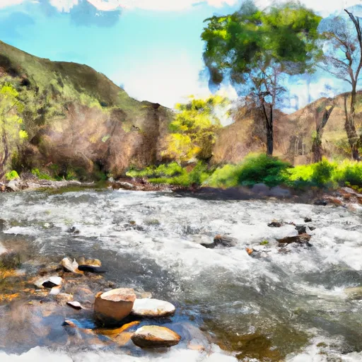
Willow Creek, located in Northern California, is a popular whitewater river run that offers exciting rapids and scenic views. The ideal streamflow range for this river is between 800-2,500 cfs. The river has a class rating of III-IV, meaning it is suitable for experienced paddlers who are comfortable with technical rapids and obstacles. The segment mileage for the Willow Creek run is approximately 14 miles, providing plenty of opportunities for paddlers to experience the river's unique challenges.
Some of the notable rapids and obstacles on the Willow Creek run include the Meatgrinder, a steep drop with a large boulder in the middle of the river that creates a challenging and technical rapid. Another challenging rapid is the Willow Creek Slide, which is a long and narrow chute that requires precise maneuvering to navigate safely. Paddlers should also be aware of the numerous rocks and boulders that line the river, as well as the occasional downed tree that can create dangerous obstacles.
Regulations for the Willow Creek run vary depending on the specific segment of the river being paddled. Some sections of the river may require permits or have seasonal restrictions in place. Additionally, paddlers should always be mindful of their impact on the environment and practice Leave No Trace principles to help preserve the natural beauty of the area.
Plan your run down to the hour
Same weather feed Snoflo's iOS app uses -- updated continuously from NOAA / yr.no. Watch the precipitation column on the meteogram; rain ahead of a run typically lifts flows 12-48 hours later depending on the basin.
Next 5 days, hour by hour
Temperature line with weather symbols on top, snow + rain accumulation as columns, humidity as a dotted line.
5-day forecast table
Every 3 hours, broken out across temperature, snow, rain, humidity, and wind. Each cell is colour-coded relative to the column min/max.
| Time | Condition | Temp (°F) | Snow (in) | Rain (in) | Humidity (%) | Wind (mps) | Wind dir |
|---|---|---|---|---|---|---|---|
| Loading detailed forecast… | |||||||
15-day temperature & precipitation
Daily temperatures, snow, and rain projected over the next two weeks -- the upstream story that drives next week's flows.
Regional streamflow levels
USGS streamgauges around Willow Creek -- useful for spotting upstream pulses and gauging which tributary is contributing what.
| Streamgauge | Discharge | View |
|---|---|---|
| Spanish C Ab Blackhawk C At Keddie Ca | 29 cfs | → |
| Spanish C A Quincy Ca | 15 cfs | → |
| Hat C Nr Hat Creek Ca | 120 cfs | → |
| Sf Pit R Nr Likely Ca | 111 cfs | → |
| Pit R Bl Pit No 1 Ph Nr Fall River Mills Ca | 1,190 cfs | → |
| Pit R Nr Canby Ca | 1 cfs | → |
Plan a longer trip
The closest boat launches, other paddle runs, and campgrounds so a day on the water can grow into a full weekend.
Boat launches
Other river runs
- Within Tunnison Wsa To Within Tunnison Wsa
- Susan River
- 1 Mile West Of Devil's Corral To To Susanville
- Smoke Creek
Campgrounds
Fishing spots
Whitewater safety
- Check the flow before you run
- Use the linked-gauge card and Regional Flow panel above. Class ratings change with flow -- a Class III at low water can become Class IV+ at high water.
- Know your skill ceiling
- Pick runs comfortably below your ceiling. Cold-water and big-water runs raise the consequences of any mistake.
- Wear the right gear
- Helmet, PFD, drysuit / wetsuit when water is below 60°F. Throw bag, knife, and whistle on your person, not in the boat.
- Scout, set safety, and run with a team
- Scout new rapids on foot, set safety with throw bags above the consequence pool, and run with at least one other competent paddler.
- Respect the river
- Strainers, undercuts, low-head dams, and wood can kill at any class rating. When in doubt, portage.
Set push alerts in the Snoflo app
Save Willow Creek as a favorite, set a discharge threshold (e.g. "alert me when flow hits 600 cfs"), and the iOS app pushes the moment the linked gauge crosses.
About Willow Creek
What's the optimal flow for Willow Creek?
The optimal flow depends on the section and the craft. Check the Run Details panel for the linked gauge and current status.
How fresh is the cfs reading on this page?
The linked USGS streamgauge reports continuously (every 15 minutes); Snoflo refreshes throughout the day. Hover the streamflow sparkline to read individual datapoints.
What's the whitewater class?
See the Run Details panel for the class rating Snoflo tracks for this run. Class ratings change with flow -- a Class III at low water can become Class IV in high water.
Where do I put in / take out?
Tap Directions in the hero above to open driving directions to the put-in. For shuttle planning, check the Nearby Boat Launches panel and the river run operator's site.
Can I get alerts when flows hit the optimal range?
Yes -- alerts are managed in the Snoflo iOS app. Favorite this run, set a discharge threshold, and you'll get a push the moment the gauge crosses.
Other runs near here
Snoflo-tracked paddle runs within driving distance of Willow Creek.