Bear Creak, South Fork river run
Community Reviews
Been here? Share the conditions.
Reviews, ratings & photos are added in the free Snoflo iOS app — rate a spot, tag the conditions, and your visit is verified by location. Add or manage your reviews from the app.
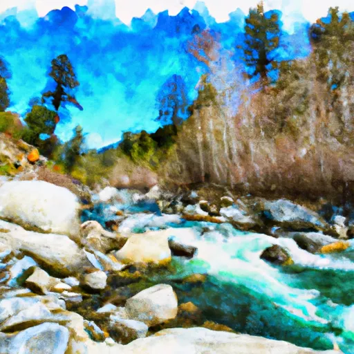
Bear Creak, South Fork
With a class rating ranging from III to IV, the South Fork of Bear Creek offers a thrilling ride for those looking for a challenge. The segment mileage of this river run varies depending on the put-in and take-out locations, but typically ranges between 6 and 8 miles.
Some of the notable rapids and obstacles on the South Fork of Bear Creek include "The Squeeze," "Whitewater Falls," and "Deadwood." Each of these rapids presents its own unique challenge, making the run exciting and unpredictable.
There are specific regulations in place for those looking to navigate the South Fork of Bear Creek. For example, all rafters must wear personal flotation devices and helmets at all times while on the river. Additionally, there are restrictions on the number of people allowed in each raft, with a limit of 6 people per raft.
Overall, the South Fork of Bear Creek offers a thrilling whitewater experience for those who are up for the challenge. However, it's important to adhere to all regulations and safety guidelines to ensure a safe and enjoyable trip.
Plan your run down to the hour
Same weather feed Snoflo's iOS app uses -- updated continuously from NOAA / yr.no. Watch the precipitation column on the meteogram; rain ahead of a run typically lifts flows 12-48 hours later depending on the basin.
Next 5 days, hour by hour
Temperature line with weather symbols on top, snow + rain accumulation as columns, humidity as a dotted line.
5-day forecast table
Every 3 hours, broken out across temperature, snow, rain, humidity, and wind. Each cell is colour-coded relative to the column min/max.
| Time | Condition | Temp (°F) | Snow (in) | Rain (in) | Humidity (%) | Wind (mps) | Wind dir |
|---|---|---|---|---|---|---|---|
| Loading detailed forecast… | |||||||
15-day temperature & precipitation
Daily temperatures, snow, and rain projected over the next two weeks -- the upstream story that drives next week's flows.
Regional streamflow levels
USGS streamgauges around Bear Creak, South Fork -- useful for spotting upstream pulses and gauging which tributary is contributing what.
| Streamgauge | Discharge | View |
|---|---|---|
| Mattole R Nr Ettersburg Ca | 21 cfs | → |
| Sf Eel R Nr Miranda Ca | 50 cfs | → |
| Sf Eel R A Leggett Ca | 34 cfs | → |
| Bull C Nr Weott Ca | 2 cfs | → |
| Mattole R Nr Petrolia Ca | 39 cfs | → |
| Eel R A Fort Seward Ca | 79 cfs | → |
Plan a longer trip
The closest boat launches, other paddle runs, and campgrounds so a day on the water can grow into a full weekend.
Other river runs
- From Headwaters In Sec. 11, T5s, R1e, Hm To To The Pacific Ocean
- From Its Headwaters In Sec. 1, T5s, R1e, Hm To To Its Junction With The Mattole River
- Southeast 1/4 Of Sec. 1 T5s, R1e, Hm To To Its Junction With The Main Stem
- Bridge Creek
- Southwest And Northwest 1/4 Of Sec. 36 T4s, R1e, Hm. To To Its Junction With Big Creek
Campgrounds
Whitewater safety
- Check the flow before you run
- Use the linked-gauge card and Regional Flow panel above. Class ratings change with flow -- a Class III at low water can become Class IV+ at high water.
- Know your skill ceiling
- Pick runs comfortably below your ceiling. Cold-water and big-water runs raise the consequences of any mistake.
- Wear the right gear
- Helmet, PFD, drysuit / wetsuit when water is below 60°F. Throw bag, knife, and whistle on your person, not in the boat.
- Scout, set safety, and run with a team
- Scout new rapids on foot, set safety with throw bags above the consequence pool, and run with at least one other competent paddler.
- Respect the river
- Strainers, undercuts, low-head dams, and wood can kill at any class rating. When in doubt, portage.
Set push alerts in the Snoflo app
Save Bear Creak, South Fork as a favorite, set a discharge threshold (e.g. "alert me when flow hits 600 cfs"), and the iOS app pushes the moment the linked gauge crosses.
About Bear Creak, South Fork
What's the optimal flow for Bear Creak, South Fork?
The optimal flow depends on the section and the craft. Check the Run Details panel for the linked gauge and current status.
How fresh is the cfs reading on this page?
The linked USGS streamgauge reports continuously (every 15 minutes); Snoflo refreshes throughout the day. Hover the streamflow sparkline to read individual datapoints.
What's the whitewater class?
See the Run Details panel for the class rating Snoflo tracks for this run. Class ratings change with flow -- a Class III at low water can become Class IV in high water.
Where do I put in / take out?
Tap Directions in the hero above to open driving directions to the put-in. For shuttle planning, check the Nearby Boat Launches panel and the river run operator's site.
Can I get alerts when flows hit the optimal range?
Yes -- alerts are managed in the Snoflo iOS app. Favorite this run, set a discharge threshold, and you'll get a push the moment the gauge crosses.
Other runs near here
Snoflo-tracked paddle runs within driving distance of Bear Creak, South Fork.