Curecanti National Recreation Area Boundary To High Water Line Of Morrow Point Reservoir River Run
Community Reviews
Been here? Share the conditions.
Reviews, ratings & photos are added in the free Snoflo iOS app — rate a spot, tag the conditions, and your visit is verified by location. Add or manage your reviews from the app.
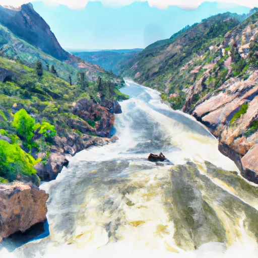
Curecanti National Recreation Area Boundary To High Water Line Of Morrow Point Reservoir
There are several notable rapids and obstacles on this river run, including the Pinnacle, a Class IV rapid. Other notable rapids include the Six Mile Gap, the Gate, and the Chukar. It is important to note that the river can be dangerous at high flows, and caution should always be exercised.
There are specific regulations that apply to this area, including restrictions on camping and campfires, as well as restrictions on the use of motorized watercraft. Visitors should also be aware that this area is home to protected wildlife, and should take care not to disturb or harm any animals.
Plan your run down to the hour
Same weather feed Snoflo's iOS app uses -- updated continuously from NOAA / yr.no. Watch the precipitation column on the meteogram; rain ahead of a run typically lifts flows 12-48 hours later depending on the basin.
Next 5 days, hour by hour
Temperature line with weather symbols on top, snow + rain accumulation as columns, humidity as a dotted line.
5-day forecast table
Every 3 hours, broken out across temperature, snow, rain, humidity, and wind. Each cell is colour-coded relative to the column min/max.
| Time | Condition | Temp (°F) | Snow (in) | Rain (in) | Humidity (%) | Wind (mps) | Wind dir |
|---|---|---|---|---|---|---|---|
| Loading detailed forecast… | |||||||
15-day temperature & precipitation
Daily temperatures, snow, and rain projected over the next two weeks -- the upstream story that drives next week's flows.
Regional streamflow levels
USGS streamgauges around Curecanti National Recreation Area Boundary To High Water Line Of Morrow Point Reservoir -- useful for spotting upstream pulses and gauging which tributary is contributing what.
| Streamgauge | Discharge | View |
|---|---|---|
| Cimarron River Bl Squaw Creek | 16 cfs | → |
| Gunnison River Below Gunnison Tunnel | 241 cfs | → |
| Lake Fork At Gateview | 112 cfs | → |
| Cimarron River Near Cimarron | 54 cfs | → |
| Uncompahgre River At Colona | 71 cfs | → |
| Smith Fork Near Lazear | · | → |
Plan a longer trip
The closest boat launches, other paddle runs, and campgrounds so a day on the water can grow into a full weekend.
Boat launches
- Us 50 Sapinero
- Ponderosa Campground Gunnison County
- Dillon Pinnacles Trail Gunnison County
- Us 50 Gunnison County
- Silver Thread Scenic Byway Gunnison County
Other river runs
- Curecanti National Recreation Area Boundary To High Water Line Of Blue Mesa Reservoir
- The Southern Boundary Of The Black Canyon Gunnison National Monument To The Painted Wall
Campgrounds
- Curecanti Creek
- Blue Creek Boat-In Campsite
- Curecanti Creek Boat-In Campsite
- Narrows Boat-In Campsite
- Nelson's Gulch Boat-In Campsite
- Dead Man's Curve Boat-In Campsite
Fishing spots
- Morrow Point Reservoir
- Crystal Reservoir
- Blue Mesa Reservoir
- Gould Reservoir
- Beaver Lake Day Use Area/ Fishing Site
- Silver Jack Reservoir
Whitewater safety
- Check the flow before you run
- Use the linked-gauge card and Regional Flow panel above. Class ratings change with flow -- a Class III at low water can become Class IV+ at high water.
- Know your skill ceiling
- Pick runs comfortably below your ceiling. Cold-water and big-water runs raise the consequences of any mistake.
- Wear the right gear
- Helmet, PFD, drysuit / wetsuit when water is below 60°F. Throw bag, knife, and whistle on your person, not in the boat.
- Scout, set safety, and run with a team
- Scout new rapids on foot, set safety with throw bags above the consequence pool, and run with at least one other competent paddler.
- Respect the river
- Strainers, undercuts, low-head dams, and wood can kill at any class rating. When in doubt, portage.
Set push alerts in the Snoflo app
Save Curecanti National Recreation Area Boundary To High Water Line Of Morrow Point Reservoir as a favorite, set a discharge threshold (e.g. "alert me when flow hits 600 cfs"), and the iOS app pushes the moment the linked gauge crosses.
About Curecanti National Recreation Area Boundary To High Water Line Of Morrow Point Reservoir
What's the optimal flow for Curecanti National Recreation Area Boundary To High Water Line Of Morrow Point Reservoir?
The optimal flow depends on the section and the craft. Check the Run Details panel for the linked gauge and current status.
How fresh is the cfs reading on this page?
The linked USGS streamgauge reports continuously (every 15 minutes); Snoflo refreshes throughout the day. Hover the streamflow sparkline to read individual datapoints.
What's the whitewater class?
See the Run Details panel for the class rating Snoflo tracks for this run. Class ratings change with flow -- a Class III at low water can become Class IV in high water.
Where do I put in / take out?
Tap Directions in the hero above to open driving directions to the put-in. For shuttle planning, check the Nearby Boat Launches panel and the river run operator's site.
Can I get alerts when flows hit the optimal range?
Yes -- alerts are managed in the Snoflo iOS app. Favorite this run, set a discharge threshold, and you'll get a push the moment the gauge crosses.
Other runs near here
Snoflo-tracked paddle runs within driving distance of Curecanti National Recreation Area Boundary To High Water Line Of Morrow Point Reservoir.