La Sal Creek Segment 1 River Run
Community Reviews
Been here? Share the conditions.
Reviews, ratings & photos are added in the free Snoflo iOS app — rate a spot, tag the conditions, and your visit is verified by location. Add or manage your reviews from the app.
La Sal Creek Segment 1
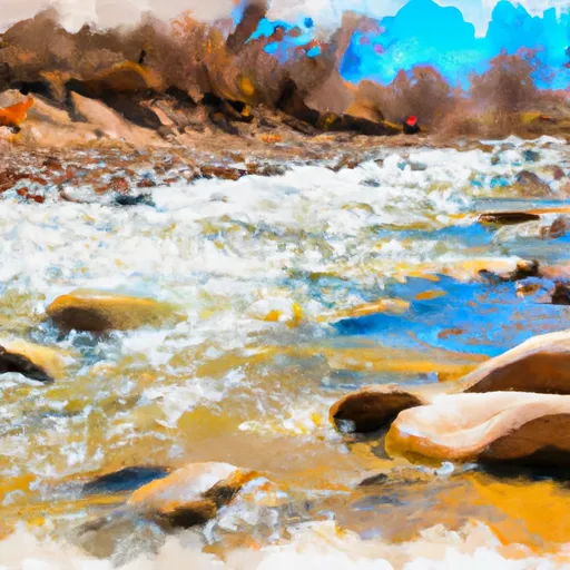
There are several notable rapids and obstacles on this segment, including the "Twin Towers," "Ice Box," and "Z-Drop." The Twin Towers is a double drop rapid that requires precise maneuvering, while the Ice Box is a steep and narrow rapid with a large rock in the center. The Z-Drop is a technical rapid with a steep drop and a tight turn at the bottom.
It is important to note that this segment is located on private property, and access is only permitted with a permit from the landowner. Permits can be obtained through local outfitters or by contacting the landowner directly. Additionally, all boaters must adhere to Colorado state regulations, including wearing a life jacket and carrying proper safety equipment on board.
In summary, the La Sal Creek Segment 1 is a thrilling whitewater river run with a class rating of III-IV, covering approximately 6 miles with several notable rapids and obstacles. The ideal streamflow range is between 800-1500 cfs, and boaters must obtain a permit from the landowner and follow all Colorado state regulations.
Plan your run down to the hour
Same weather feed Snoflo's iOS app uses -- updated continuously from NOAA / yr.no. Watch the precipitation column on the meteogram; rain ahead of a run typically lifts flows 12-48 hours later depending on the basin.
Next 5 days, hour by hour
Temperature line with weather symbols on top, snow + rain accumulation as columns, humidity as a dotted line.
5-day forecast table
Every 3 hours, broken out across temperature, snow, rain, humidity, and wind. Each cell is colour-coded relative to the column min/max.
| Time | Condition | Temp (°F) | Snow (in) | Rain (in) | Humidity (%) | Wind (mps) | Wind dir |
|---|---|---|---|---|---|---|---|
| Loading detailed forecast… | |||||||
15-day temperature & precipitation
Daily temperatures, snow, and rain projected over the next two weeks -- the upstream story that drives next week's flows.
Regional streamflow levels
USGS streamgauges around La Sal Creek Segment 1 -- useful for spotting upstream pulses and gauging which tributary is contributing what.
| Streamgauge | Discharge | View |
|---|---|---|
| Dolores River At Bedrock | 0 cfs | → |
| Dolores River Near Bedrock | 2 cfs | → |
| San Miguel River At Uravan | 28 cfs | → |
| Dolores River Near Slick Rock | · | → |
| Mill Creek At Sheley Tunnel | 3 cfs | → |
| Mill Creek Below Sheley Tunnel | 3 cfs | → |
Plan a longer trip
The closest boat launches, other paddle runs, and campgrounds so a day on the water can grow into a full weekend.
Other river runs
- Ice Lake Creek Segment 2
- Ice Lake Creek Segment 1
- Lion Creek Segment 2
- Lion Creek Segment 1
- Spring Creek
Campgrounds
- Buckeye
- Buckeye Recreation Area
- Mount Peale Free Camping
- Dolores River Camp 4
- Dolores River Camp 5
- Dolores River Camp 2
Fishing spots
Whitewater safety
- Check the flow before you run
- Use the linked-gauge card and Regional Flow panel above. Class ratings change with flow -- a Class III at low water can become Class IV+ at high water.
- Know your skill ceiling
- Pick runs comfortably below your ceiling. Cold-water and big-water runs raise the consequences of any mistake.
- Wear the right gear
- Helmet, PFD, drysuit / wetsuit when water is below 60°F. Throw bag, knife, and whistle on your person, not in the boat.
- Scout, set safety, and run with a team
- Scout new rapids on foot, set safety with throw bags above the consequence pool, and run with at least one other competent paddler.
- Respect the river
- Strainers, undercuts, low-head dams, and wood can kill at any class rating. When in doubt, portage.
Set push alerts in the Snoflo app
Save La Sal Creek Segment 1 as a favorite, set a discharge threshold (e.g. "alert me when flow hits 600 cfs"), and the iOS app pushes the moment the linked gauge crosses.
About La Sal Creek Segment 1
What's the optimal flow for La Sal Creek Segment 1?
The optimal flow depends on the section and the craft. Check the Run Details panel for the linked gauge and current status.
How fresh is the cfs reading on this page?
The linked USGS streamgauge reports continuously (every 15 minutes); Snoflo refreshes throughout the day. Hover the streamflow sparkline to read individual datapoints.
What's the whitewater class?
See the Run Details panel for the class rating Snoflo tracks for this run. Class ratings change with flow -- a Class III at low water can become Class IV in high water.
Where do I put in / take out?
Tap Directions in the hero above to open driving directions to the put-in. For shuttle planning, check the Nearby Boat Launches panel and the river run operator's site.
Can I get alerts when flows hit the optimal range?
Yes -- alerts are managed in the Snoflo iOS app. Favorite this run, set a discharge threshold, and you'll get a push the moment the gauge crosses.
Other runs near here
Snoflo-tracked paddle runs within driving distance of La Sal Creek Segment 1.