West Fork Terror Creek river run
Community Reviews
Been here? Share the conditions.
Reviews, ratings & photos are added in the free Snoflo iOS app — rate a spot, tag the conditions, and your visit is verified by location. Add or manage your reviews from the app.
West Fork Terror Creek
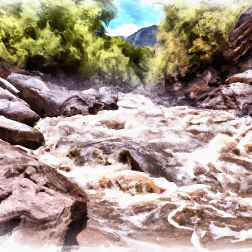
The segment mileage for the West Fork of Terror Creek is approximately 10 miles, and it can be broken down into several distinct sections. The upper section of the run is characterized by steep drops and tight boulder gardens, while the lower section is more continuous with numerous class IV and V rapids.
Some of the specific rapids and obstacles to watch out for on this run include the Entrance Exam, the S-Turn, the Pinball Wizard, and the infamous Charlie’s Hole. These rapids all feature technical drops, chutes, and steep gradient changes that can be challenging even for experienced boaters.
There are some specific regulations that apply to the West Fork of Terror Creek, including a seasonal closure from December 1 to April 30 to protect wintering wildlife. Additionally, boaters are required to obtain a permit from the United States Forest Service before entering the area.
In summary, the West Fork of Terror Creek is a challenging and exciting whitewater run that requires a high degree of technical skill and experience. Boaters should be prepared for steep drops, tight boulder gardens, and class IV-V rapids, and should be familiar with the specific regulations and permit requirements for the area.
Plan your run down to the hour
Same weather feed Snoflo's iOS app uses -- updated continuously from NOAA / yr.no. Watch the precipitation column on the meteogram; rain ahead of a run typically lifts flows 12-48 hours later depending on the basin.
Next 5 days, hour by hour
Temperature line with weather symbols on top, snow + rain accumulation as columns, humidity as a dotted line.
5-day forecast table
Every 3 hours, broken out across temperature, snow, rain, humidity, and wind. Each cell is colour-coded relative to the column min/max.
| Time | Condition | Temp (°F) | Snow (in) | Rain (in) | Humidity (%) | Wind (mps) | Wind dir |
|---|---|---|---|---|---|---|---|
| Loading detailed forecast… | |||||||
15-day temperature & precipitation
Daily temperatures, snow, and rain projected over the next two weeks -- the upstream story that drives next week's flows.
Regional streamflow levels
USGS streamgauges around West Fork Terror Creek -- useful for spotting upstream pulses and gauging which tributary is contributing what.
| Streamgauge | Discharge | View |
|---|---|---|
| E Fork Terror Cr Blw Cottonwood Stomp Nr Bowie | 0 cfs | → |
| Hubbard Creek Above Iron Point Gulch Nr Bowie | 6 cfs | → |
| Terror Creek At Mouth Near Bowie | 2 cfs | → |
| Hubbard Creek At Highway 133 At Mouth Nr Bowie | 0 cfs | → |
| North Fork Gunnison River Below Paonia | 18 cfs | → |
| Minnesota Creek Near Paonia | 4 cfs | → |
Plan a longer trip
The closest boat launches, other paddle runs, and campgrounds so a day on the water can grow into a full weekend.
Boat launches
- Grand Avenue Delta County
- Bear Road Gunnison County
- Forest Road 125 Delta County
- Big Creek Reservoir Boat Launch Grand Valley Rd
- Forest Road 121 Mesa County
- Gunnison Forks
Other river runs
- Deep Creek
- Bogan Canyon
- South Fork--Headwaters To Beaver Lake
- Gunnison River Segment 2
- The Painted Wall To The Black Canyon Gunnison National Monument-Gunnison Gorge Wilderness Boundary
Campgrounds
- Paonia State Park
- Williams Creek Dispersed Camping Area
- Weir And Johnson
- Weir & Johnson Campground - Grand Valley Rd
- Twin Lake
- Twin Lake Dispersed Camping Area
Fishing spots
Whitewater safety
- Check the flow before you run
- Use the linked-gauge card and Regional Flow panel above. Class ratings change with flow -- a Class III at low water can become Class IV+ at high water.
- Know your skill ceiling
- Pick runs comfortably below your ceiling. Cold-water and big-water runs raise the consequences of any mistake.
- Wear the right gear
- Helmet, PFD, drysuit / wetsuit when water is below 60°F. Throw bag, knife, and whistle on your person, not in the boat.
- Scout, set safety, and run with a team
- Scout new rapids on foot, set safety with throw bags above the consequence pool, and run with at least one other competent paddler.
- Respect the river
- Strainers, undercuts, low-head dams, and wood can kill at any class rating. When in doubt, portage.
Set push alerts in the Snoflo app
Save West Fork Terror Creek as a favorite, set a discharge threshold (e.g. "alert me when flow hits 600 cfs"), and the iOS app pushes the moment the linked gauge crosses.
About West Fork Terror Creek
What's the optimal flow for West Fork Terror Creek?
The optimal flow depends on the section and the craft. Check the Run Details panel for the linked gauge and current status.
How fresh is the cfs reading on this page?
The linked USGS streamgauge reports continuously (every 15 minutes); Snoflo refreshes throughout the day. Hover the streamflow sparkline to read individual datapoints.
What's the whitewater class?
See the Run Details panel for the class rating Snoflo tracks for this run. Class ratings change with flow -- a Class III at low water can become Class IV in high water.
Where do I put in / take out?
Tap Directions in the hero above to open driving directions to the put-in. For shuttle planning, check the Nearby Boat Launches panel and the river run operator's site.
Can I get alerts when flows hit the optimal range?
Yes -- alerts are managed in the Snoflo iOS app. Favorite this run, set a discharge threshold, and you'll get a push the moment the gauge crosses.
Other runs near here
Snoflo-tracked paddle runs within driving distance of West Fork Terror Creek.