Rio Grande River Segment A river run
Community Reviews
Been here? Share the conditions.
Reviews, ratings & photos are added in the free Snoflo iOS app — rate a spot, tag the conditions, and your visit is verified by location. Add or manage your reviews from the app.
Rio Grande River Segment A
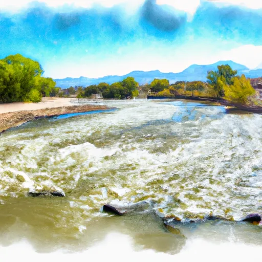
The segment covers a distance of 10 miles, starting at the Weminuche Wilderness boundary and ending at the South Fork of the Rio Grande. The river features a number of rapids and obstacles, including the Play Hole, Pinball, and the famous Toilet Bowl. The Toilet Bowl is a Class III rapid with a large hole that can flip rafts and kayaks if not navigated correctly.
There are specific regulations that apply to the Rio Grande River Segment A. The use of motorized equipment is prohibited, and all visitors must have a permit to enter the Weminuche Wilderness area. Additionally, all visitors must practice Leave No Trace principles and pack out all trash.
In summary, the Rio Grande River Segment A offers intermediate-level whitewater rafting with a Class II-III rating. The ideal streamflow range is between 300-1,000 cfs, and the segment covers a distance of 10 miles with several notable rapids and obstacles. Specific regulations apply to the area, including a prohibition on motorized equipment and a requirement for wilderness permits.
Plan your run down to the hour
Same weather feed Snoflo's iOS app uses -- updated continuously from NOAA / yr.no. Watch the precipitation column on the meteogram; rain ahead of a run typically lifts flows 12-48 hours later depending on the basin.
Next 5 days, hour by hour
Temperature line with weather symbols on top, snow + rain accumulation as columns, humidity as a dotted line.
5-day forecast table
Every 3 hours, broken out across temperature, snow, rain, humidity, and wind. Each cell is colour-coded relative to the column min/max.
| Time | Condition | Temp (°F) | Snow (in) | Rain (in) | Humidity (%) | Wind (mps) | Wind dir |
|---|---|---|---|---|---|---|---|
| Loading detailed forecast… | |||||||
15-day temperature & precipitation
Daily temperatures, snow, and rain projected over the next two weeks -- the upstream story that drives next week's flows.
Regional streamflow levels
USGS streamgauges around Rio Grande River Segment A -- useful for spotting upstream pulses and gauging which tributary is contributing what.
| Streamgauge | Discharge | View |
|---|---|---|
| Rio Grande At Alamosa | 7 cfs | → |
| Rio Grande Ab Mouth Trinchera C Nr Lasauses | 7 cfs | → |
| Trinchera Creek Below Smith Res | 0 cfs | → |
| San Antonio River At Mouth | 0 cfs | → |
| Ute Creek Near Fort Garland | 1 cfs | → |
| Sangre De Cristo Creek Near Fort Garland | 0 cfs | → |
Plan a longer trip
The closest boat launches, other paddle runs, and campgrounds so a day on the water can grow into a full weekend.
Other river runs
- Rio Grande River Segment B
- Rio Grande River Segment C
- Headwaters At Indian Spring To Ends Where The Creek Is Diverted Into Irrigation Ditches
- Headwaters To Confluence With Medano Creek
Campgrounds
- Koa Alamosa
- Basecamp Campground And Rv Park
- Base Camp Family Campground
- Ramble At Great Sand Dunes
- San Luis State Park
- San Luis Lakes State Wildlife Area Campground
Fishing spots
Whitewater safety
- Check the flow before you run
- Use the linked-gauge card and Regional Flow panel above. Class ratings change with flow -- a Class III at low water can become Class IV+ at high water.
- Know your skill ceiling
- Pick runs comfortably below your ceiling. Cold-water and big-water runs raise the consequences of any mistake.
- Wear the right gear
- Helmet, PFD, drysuit / wetsuit when water is below 60°F. Throw bag, knife, and whistle on your person, not in the boat.
- Scout, set safety, and run with a team
- Scout new rapids on foot, set safety with throw bags above the consequence pool, and run with at least one other competent paddler.
- Respect the river
- Strainers, undercuts, low-head dams, and wood can kill at any class rating. When in doubt, portage.
Set push alerts in the Snoflo app
Save Rio Grande River Segment A as a favorite, set a discharge threshold (e.g. "alert me when flow hits 600 cfs"), and the iOS app pushes the moment the linked gauge crosses.
About Rio Grande River Segment A
What's the optimal flow for Rio Grande River Segment A?
The optimal flow depends on the section and the craft. Check the Run Details panel for the linked gauge and current status.
How fresh is the cfs reading on this page?
The linked USGS streamgauge reports continuously (every 15 minutes); Snoflo refreshes throughout the day. Hover the streamflow sparkline to read individual datapoints.
What's the whitewater class?
See the Run Details panel for the class rating Snoflo tracks for this run. Class ratings change with flow -- a Class III at low water can become Class IV in high water.
Where do I put in / take out?
Tap Directions in the hero above to open driving directions to the put-in. For shuttle planning, check the Nearby Boat Launches panel and the river run operator's site.
Can I get alerts when flows hit the optimal range?
Yes -- alerts are managed in the Snoflo iOS app. Favorite this run, set a discharge threshold, and you'll get a push the moment the gauge crosses.
Other runs near here
Snoflo-tracked paddle runs within driving distance of Rio Grande River Segment A.