Little Dolores, Colo. River Segment 2 River Run
Community Reviews
Been here? Share the conditions.
Reviews, ratings & photos are added in the free Snoflo iOS app — rate a spot, tag the conditions, and your visit is verified by location. Add or manage your reviews from the app.
Little Dolores, Colo. River Segment 2
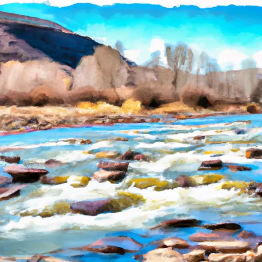
The river features several notable rapids and obstacles, including the Little D rapid, a class III+ rapid that requires careful navigation through a narrow canyon. Other notable rapids include the Roller Coaster, the Wall Rapid, and the Saddlehorn Rapid.
To ensure the safety of all visitors, the Colorado Parks and Wildlife Department has established specific regulations for the area. All boaters are required to wear personal flotation devices (PFDs) at all times while on the river. Additionally, alcohol consumption is prohibited on the river, and visitors are encouraged to pack out all trash and leave no trace behind.
Overall, the Little Dolores river run is a must-visit destination for anyone looking for a thrilling rafting adventure in western Colorado. Visitors are advised to check current streamflow conditions before planning their trip and to follow all established regulations to ensure a safe and enjoyable experience on the river.
Plan your run down to the hour
Same weather feed Snoflo's iOS app uses -- updated continuously from NOAA / yr.no. Watch the precipitation column on the meteogram; rain ahead of a run typically lifts flows 12-48 hours later depending on the basin.
Next 5 days, hour by hour
Temperature line with weather symbols on top, snow + rain accumulation as columns, humidity as a dotted line.
5-day forecast table
Every 3 hours, broken out across temperature, snow, rain, humidity, and wind. Each cell is colour-coded relative to the column min/max.
| Time | Condition | Temp (°F) | Snow (in) | Rain (in) | Humidity (%) | Wind (mps) | Wind dir |
|---|---|---|---|---|---|---|---|
| Loading detailed forecast… | |||||||
15-day temperature & precipitation
Daily temperatures, snow, and rain projected over the next two weeks -- the upstream story that drives next week's flows.
Regional streamflow levels
USGS streamgauges around Little Dolores, Colo. River Segment 2 -- useful for spotting upstream pulses and gauging which tributary is contributing what.
| Streamgauge | Discharge | View |
|---|---|---|
| Colorado River Near Colorado-Utah State Line | 1,560 cfs | → |
| Dolores River Near Cisco | 4 cfs | → |
| Colorado River Near Cisco | 1,680 cfs | → |
| Dolores River Near Gateway | 48 cfs | → |
| Castle Creek Below Castle Valley Near Moab | 4 cfs | → |
| Gunnison River Near Grand Junction | 542 cfs | → |
Plan a longer trip
The closest boat launches, other paddle runs, and campgrounds so a day on the water can grow into a full weekend.
Boat launches
- Westwater Grand County
- Westwater Ranger Station
- Boat Launch Road Grand County
- Cisco Takeout
- Grand County
- Dewey Bridge Recreation Site
Other river runs
- Marble Canyon, Colo. River Segment 2
- Star Canyon, Colo. River Segment 2
- Colorado River
- Colorado River Segment 2
- Westwater
Fishing spots
Parks
- Mcinnis Canyons National Conservation Area
- Wilderness Black Ridge Canyons
- Mcinnis Canyons National Conservation
Points of interest
Whitewater safety
- Check the flow before you run
- Use the linked-gauge card and Regional Flow panel above. Class ratings change with flow -- a Class III at low water can become Class IV+ at high water.
- Know your skill ceiling
- Pick runs comfortably below your ceiling. Cold-water and big-water runs raise the consequences of any mistake.
- Wear the right gear
- Helmet, PFD, drysuit / wetsuit when water is below 60°F. Throw bag, knife, and whistle on your person, not in the boat.
- Scout, set safety, and run with a team
- Scout new rapids on foot, set safety with throw bags above the consequence pool, and run with at least one other competent paddler.
- Respect the river
- Strainers, undercuts, low-head dams, and wood can kill at any class rating. When in doubt, portage.
Set push alerts in the Snoflo app
Save Little Dolores, Colo. River Segment 2 as a favorite, set a discharge threshold (e.g. "alert me when flow hits 600 cfs"), and the iOS app pushes the moment the linked gauge crosses.
About Little Dolores, Colo. River Segment 2
What's the optimal flow for Little Dolores, Colo. River Segment 2?
The optimal flow depends on the section and the craft. Check the Run Details panel for the linked gauge and current status.
How fresh is the cfs reading on this page?
The linked USGS streamgauge reports continuously (every 15 minutes); Snoflo refreshes throughout the day. Hover the streamflow sparkline to read individual datapoints.
What's the whitewater class?
See the Run Details panel for the class rating Snoflo tracks for this run. Class ratings change with flow -- a Class III at low water can become Class IV in high water.
Where do I put in / take out?
Tap Directions in the hero above to open driving directions to the put-in. For shuttle planning, check the Nearby Boat Launches panel and the river run operator's site.
Can I get alerts when flows hit the optimal range?
Yes -- alerts are managed in the Snoflo iOS app. Favorite this run, set a discharge threshold, and you'll get a push the moment the gauge crosses.
Other runs near here
Snoflo-tracked paddle runs within driving distance of Little Dolores, Colo. River Segment 2.