Ichetucknee Headspring To The First Powerline Crossing Over Ichetucknee River River Run
Community Reviews
Been here? Share the conditions.
Reviews, ratings & photos are added in the free Snoflo iOS app — rate a spot, tag the conditions, and your visit is verified by location. Add or manage your reviews from the app.
Ichetucknee Headspring To The First Powerline Crossing Over Ichetucknee River
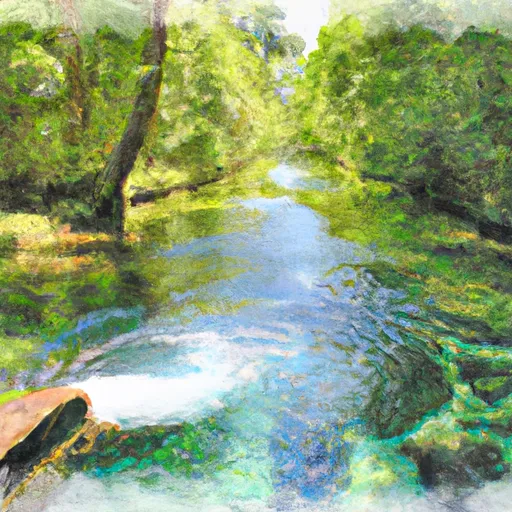
The river is known for its gentle and meandering nature, with few obstacles to navigate. There are a few small rapids that provide some excitement for paddlers, but they are generally easy to navigate. The main obstacles on the river are fallen trees and underwater rocks, which require careful attention and maneuvering to avoid.
Specific regulations to the area include a limit on the number of visitors allowed on the river at any given time, as well as restrictions on the use of alcohol and glass containers. All visitors must also wear personal flotation devices while on the river.
Overall, the Ichetucknee River offers a peaceful and enjoyable whitewater experience for paddlers of all skill levels, with clear waters and stunning scenery to enjoy along the way.
Plan your run down to the hour
Same weather feed Snoflo's iOS app uses -- updated continuously from NOAA / yr.no. Watch the precipitation column on the meteogram; rain ahead of a run typically lifts flows 12-48 hours later depending on the basin.
Next 5 days, hour by hour
Temperature line with weather symbols on top, snow + rain accumulation as columns, humidity as a dotted line.
5-day forecast table
Every 3 hours, broken out across temperature, snow, rain, humidity, and wind. Each cell is colour-coded relative to the column min/max.
| Time | Condition | Temp (°F) | Snow (in) | Rain (in) | Humidity (%) | Wind (mps) | Wind dir |
|---|---|---|---|---|---|---|---|
| Loading detailed forecast… | |||||||
15-day temperature & precipitation
Daily temperatures, snow, and rain projected over the next two weeks -- the upstream story that drives next week's flows.
Regional streamflow levels
USGS streamgauges around Ichetucknee Headspring To The First Powerline Crossing Over Ichetucknee River -- useful for spotting upstream pulses and gauging which tributary is contributing what.
| Streamgauge | Discharge | View |
|---|---|---|
| Ichetucknee R @ Hwy27 Nr Hildreth | 220 cfs | → |
| Santa Fe River Nr Hildreth Fla | 902 cfs | → |
| Santa Fe River Near Fort White | 555 cfs | → |
| Suwannee River At Branford | 2,090 cfs | → |
| Santa Fe River At O'Leno State Park Fla | 30 cfs | → |
| Santa Fe River At River Rise Nr High Springs | 18 cfs | → |
Plan a longer trip
The closest boat launches, other paddle runs, and campgrounds so a day on the water can grow into a full weekend.
Boat launches
- Ira Bea Oasis (Tudeen) Boat Ramp
- 108th Place Public Boat Ramp
- William Guy Lemon Park
- Hollingsworth Bluff Boat Ramp
- Highway 47 22430, Fort White
- Ellie Ray's River Landing
Other river runs
- The First Powerline Crossing The Ichetuckee River To The Confluence With The Santa Fe River, Down The Santa Fe River To The Suwannee River
- The Little River Springs At River Mile 81 To The Mouth Of The River At The Gulf Of Mexico
- The Confluence Of The North Prong And Middle Prong To Trader's Hill
- State Highway 6 To The Confluence With The Suwannee River
Campgrounds
- Ichetucknee Springs Campground
- Bowman’S Landing
- Ellie Ray's Rv Resort & Lounge
- Oleno State Park
- Dogwood Campsite
- October Bend Rv Park
Fishing spots
Whitewater safety
- Check the flow before you run
- Use the linked-gauge card and Regional Flow panel above. Class ratings change with flow -- a Class III at low water can become Class IV+ at high water.
- Know your skill ceiling
- Pick runs comfortably below your ceiling. Cold-water and big-water runs raise the consequences of any mistake.
- Wear the right gear
- Helmet, PFD, drysuit / wetsuit when water is below 60°F. Throw bag, knife, and whistle on your person, not in the boat.
- Scout, set safety, and run with a team
- Scout new rapids on foot, set safety with throw bags above the consequence pool, and run with at least one other competent paddler.
- Respect the river
- Strainers, undercuts, low-head dams, and wood can kill at any class rating. When in doubt, portage.
Set push alerts in the Snoflo app
Save Ichetucknee Headspring To The First Powerline Crossing Over Ichetucknee River as a favorite, set a discharge threshold (e.g. "alert me when flow hits 600 cfs"), and the iOS app pushes the moment the linked gauge crosses.
About Ichetucknee Headspring To The First Powerline Crossing Over Ichetucknee River
What's the optimal flow for Ichetucknee Headspring To The First Powerline Crossing Over Ichetucknee River?
The optimal flow depends on the section and the craft. Check the Run Details panel for the linked gauge and current status.
How fresh is the cfs reading on this page?
The linked USGS streamgauge reports continuously (every 15 minutes); Snoflo refreshes throughout the day. Hover the streamflow sparkline to read individual datapoints.
What's the whitewater class?
See the Run Details panel for the class rating Snoflo tracks for this run. Class ratings change with flow -- a Class III at low water can become Class IV in high water.
Where do I put in / take out?
Tap Directions in the hero above to open driving directions to the put-in. For shuttle planning, check the Nearby Boat Launches panel and the river run operator's site.
Can I get alerts when flows hit the optimal range?
Yes -- alerts are managed in the Snoflo iOS app. Favorite this run, set a discharge threshold, and you'll get a push the moment the gauge crosses.
Other runs near here
Snoflo-tracked paddle runs within driving distance of Ichetucknee Headspring To The First Powerline Crossing Over Ichetucknee River.