Mainstem And Lower 2 Miles Of North, South And Siddoway Forks To One Mile Above Trailhead River Run
Community Reviews
Been here? Share the conditions.
Reviews, ratings & photos are added in the free Snoflo iOS app — rate a spot, tag the conditions, and your visit is verified by location. Add or manage your reviews from the app.
Mainstem And Lower 2 Miles Of North, South And Siddoway Forks To One Mile Above Trailhead
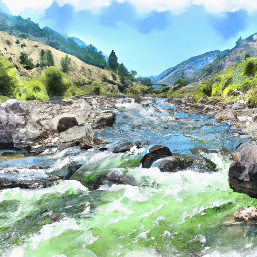
The river rapids/obstacles on this run include many Class IV-V drops, narrow canyons, and steep drops. Some of the notable rapids and obstacles are the Powerhouse Rapid, the Flat Creek Rapid, the Jump Off, and the Propane Rapid. Rafters should be prepared for big waves, technical rapids, and strong currents.
The specific regulations to the area include obtaining a permit from the Bureau of Land Management (BLM) before embarking on the river run. The BLM also regulates the number of rafters allowed on the river run at any given time. Additionally, all rafters are required to wear personal flotation devices and follow Leave No Trace principles.
In conclusion, the Whitewater River run in Idaho is a challenging yet exhilarating experience for experienced rafters. The ideal streamflow range is between 500 and 2500 cfs, and the river is rated as a class IV-V. The segment mileage is approximately 5.5 miles, and rafters should be prepared for big waves, technical rapids, and strong currents. Specific regulations include obtaining a permit, following Leave No Trace principles, and wearing personal flotation devices.
Plan your run down to the hour
Same weather feed Snoflo's iOS app uses -- updated continuously from NOAA / yr.no. Watch the precipitation column on the meteogram; rain ahead of a run typically lifts flows 12-48 hours later depending on the basin.
Next 5 days, hour by hour
Temperature line with weather symbols on top, snow + rain accumulation as columns, humidity as a dotted line.
5-day forecast table
Every 3 hours, broken out across temperature, snow, rain, humidity, and wind. Each cell is colour-coded relative to the column min/max.
| Time | Condition | Temp (°F) | Snow (in) | Rain (in) | Humidity (%) | Wind (mps) | Wind dir |
|---|---|---|---|---|---|---|---|
| Loading detailed forecast… | |||||||
15-day temperature & precipitation
Daily temperatures, snow, and rain projected over the next two weeks -- the upstream story that drives next week's flows.
Regional streamflow levels
USGS streamgauges around Mainstem And Lower 2 Miles Of North, South And Siddoway Forks To One Mile Above Trailhead -- useful for spotting upstream pulses and gauging which tributary is contributing what.
| Streamgauge | Discharge | View |
|---|---|---|
| Snake River Nr Irwin Id | 9,380 cfs | → |
| Snake River Ab Reservoir Nr Alpine Wy | 7,170 cfs | → |
| Greys River Ab Reservoir Nr Alpine Wy | 387 cfs | → |
| Fish Creek At Wilson | 371 cfs | → |
| Flat Creek Bel Cache Creek | 168 cfs | → |
| Salt River Ab Reservoir Nr Etna Wy | 339 cfs | → |
Plan a longer trip
The closest boat launches, other paddle runs, and campgrounds so a day on the water can grow into a full weekend.
Boat launches
Other river runs
- One Mile Above Trailhead To Trailhead
- Source To Upper Palisades Lake
- Palisade Dam To Lorenzo (South Fork)
- South Fork Snake River
- Confluence Of North Fork Palisades Creek And Corral Canyon To Palisades Campground
Campgrounds
Fishing spots
Whitewater safety
- Check the flow before you run
- Use the linked-gauge card and Regional Flow panel above. Class ratings change with flow -- a Class III at low water can become Class IV+ at high water.
- Know your skill ceiling
- Pick runs comfortably below your ceiling. Cold-water and big-water runs raise the consequences of any mistake.
- Wear the right gear
- Helmet, PFD, drysuit / wetsuit when water is below 60°F. Throw bag, knife, and whistle on your person, not in the boat.
- Scout, set safety, and run with a team
- Scout new rapids on foot, set safety with throw bags above the consequence pool, and run with at least one other competent paddler.
- Respect the river
- Strainers, undercuts, low-head dams, and wood can kill at any class rating. When in doubt, portage.
Set push alerts in the Snoflo app
Save Mainstem And Lower 2 Miles Of North, South And Siddoway Forks To One Mile Above Trailhead as a favorite, set a discharge threshold (e.g. "alert me when flow hits 600 cfs"), and the iOS app pushes the moment the linked gauge crosses.
About Mainstem And Lower 2 Miles Of North, South And Siddoway Forks To One Mile Above Trailhead
What's the optimal flow for Mainstem And Lower 2 Miles Of North, South And Siddoway Forks To One Mile Above Trailhead?
The optimal flow depends on the section and the craft. Check the Run Details panel for the linked gauge and current status.
How fresh is the cfs reading on this page?
The linked USGS streamgauge reports continuously (every 15 minutes); Snoflo refreshes throughout the day. Hover the streamflow sparkline to read individual datapoints.
What's the whitewater class?
See the Run Details panel for the class rating Snoflo tracks for this run. Class ratings change with flow -- a Class III at low water can become Class IV in high water.
Where do I put in / take out?
Tap Directions in the hero above to open driving directions to the put-in. For shuttle planning, check the Nearby Boat Launches panel and the river run operator's site.
Can I get alerts when flows hit the optimal range?
Yes -- alerts are managed in the Snoflo iOS app. Favorite this run, set a discharge threshold, and you'll get a push the moment the gauge crosses.
Other runs near here
Snoflo-tracked paddle runs within driving distance of Mainstem And Lower 2 Miles Of North, South And Siddoway Forks To One Mile Above Trailhead.