Southern Boundary Of State Land To Mouth River Run
Community Reviews
Been here? Share the conditions.
Reviews, ratings & photos are added in the free Snoflo iOS app — rate a spot, tag the conditions, and your visit is verified by location. Add or manage your reviews from the app.
Southern Boundary Of State Land To Mouth
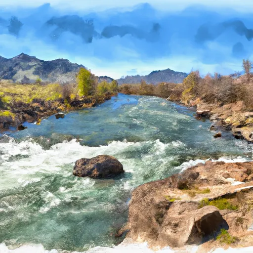
The Whitewater River Run Southern Boundary of State Land to Mouth is a popular river run in Idaho, offering a thrilling adventure for experienced kayakers and rafters. The ideal streamflow range for this run is between 1,500 and 3,000 cfs, as any higher or lower can make it too difficult or too dangerous to navigate.
This run is classified as a class III-IV, which means it has moderate to difficult rapids and requires skill and experience to navigate. The segment mileage of this run is 18.8 miles, starting from the southern boundary of state land and ending at the mouth of the river.
Some of the specific river rapids and obstacles that kayakers and rafters may encounter on this run include the Whitewater Falls, which is a 20-foot waterfall that requires careful navigation, as well as the Big Rocks Rapid, which has large boulders and fast-moving water.
There are specific regulations that must be followed in this area, including carrying a personal flotation device (PFD) for each person on board, as well as having a whistle and a throwable device on hand. Additionally, there are restrictions on the use of motorized boats and certain types of fishing equipment.
Plan your run down to the hour
Same weather feed Snoflo's iOS app uses -- updated continuously from NOAA / yr.no. Watch the precipitation column on the meteogram; rain ahead of a run typically lifts flows 12-48 hours later depending on the basin.
Next 5 days, hour by hour
Temperature line with weather symbols on top, snow + rain accumulation as columns, humidity as a dotted line.
5-day forecast table
Every 3 hours, broken out across temperature, snow, rain, humidity, and wind. Each cell is colour-coded relative to the column min/max.
| Time | Condition | Temp (°F) | Snow (in) | Rain (in) | Humidity (%) | Wind (mps) | Wind dir |
|---|---|---|---|---|---|---|---|
| Loading detailed forecast… | |||||||
15-day temperature & precipitation
Daily temperatures, snow, and rain projected over the next two weeks -- the upstream story that drives next week's flows.
Regional streamflow levels
USGS streamgauges around Southern Boundary Of State Land To Mouth -- useful for spotting upstream pulses and gauging which tributary is contributing what.
| Streamgauge | Discharge | View |
|---|---|---|
| Logan | 71 cfs | → |
| Logan River Above State Dam | 79 cfs | → |
| Bear River At Idaho-Utah State Line | 988 cfs | → |
| Blacksmith Fork Ab U.P.&L. Co | 52 cfs | → |
| Big Creek Near Randolph | 3 cfs | → |
| Little Bear River At Paradise | 14 cfs | → |
Plan a longer trip
The closest boat launches, other paddle runs, and campgrounds so a day on the water can grow into a full weekend.
Boat launches
- Bear Lake State Park
- Rendezvous Beach State Park
- North Cisco Road Rich County
- Lamont Reservoir
- East Shore Marina
Other river runs
Campgrounds
- Red Banks Campground
- Lewis M. Turner Campground
- Tony Grove Lake Campground
- Tony Grove Lake
- Sunrise Campground
- Bear Lake Marina Campground
Whitewater safety
- Check the flow before you run
- Use the linked-gauge card and Regional Flow panel above. Class ratings change with flow -- a Class III at low water can become Class IV+ at high water.
- Know your skill ceiling
- Pick runs comfortably below your ceiling. Cold-water and big-water runs raise the consequences of any mistake.
- Wear the right gear
- Helmet, PFD, drysuit / wetsuit when water is below 60°F. Throw bag, knife, and whistle on your person, not in the boat.
- Scout, set safety, and run with a team
- Scout new rapids on foot, set safety with throw bags above the consequence pool, and run with at least one other competent paddler.
- Respect the river
- Strainers, undercuts, low-head dams, and wood can kill at any class rating. When in doubt, portage.
Set push alerts in the Snoflo app
Save Southern Boundary Of State Land To Mouth as a favorite, set a discharge threshold (e.g. "alert me when flow hits 600 cfs"), and the iOS app pushes the moment the linked gauge crosses.
About Southern Boundary Of State Land To Mouth
What's the optimal flow for Southern Boundary Of State Land To Mouth?
The optimal flow depends on the section and the craft. Check the Run Details panel for the linked gauge and current status.
How fresh is the cfs reading on this page?
The linked USGS streamgauge reports continuously (every 15 minutes); Snoflo refreshes throughout the day. Hover the streamflow sparkline to read individual datapoints.
What's the whitewater class?
See the Run Details panel for the class rating Snoflo tracks for this run. Class ratings change with flow -- a Class III at low water can become Class IV in high water.
Where do I put in / take out?
Tap Directions in the hero above to open driving directions to the put-in. For shuttle planning, check the Nearby Boat Launches panel and the river run operator's site.
Can I get alerts when flows hit the optimal range?
Yes -- alerts are managed in the Snoflo iOS app. Favorite this run, set a discharge threshold, and you'll get a push the moment the gauge crosses.
Other runs near here
Snoflo-tracked paddle runs within driving distance of Southern Boundary Of State Land To Mouth.