Forest Road 2133 To Forest Road 2156 River Run
Community Reviews
Been here? Share the conditions.
Reviews, ratings & photos are added in the free Snoflo iOS app — rate a spot, tag the conditions, and your visit is verified by location. Add or manage your reviews from the app.
Forest Road 2133 To Forest Road 2156
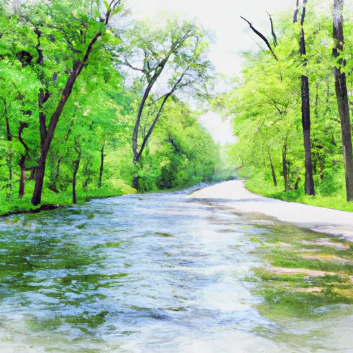
The Whitewater River Run in Illinois stretches from Forest Road 2133 to Forest Road 2156 and is a popular destination for kayaking and rafting enthusiasts. The ideal streamflow range for this river is between 200-500 cubic feet per second (cfs), although it can vary depending on weather conditions. The class rating is around II-III, which means it is suitable for intermediate paddlers.
The segment mileage of the Whitewater River Run is approximately 7 miles, with several rapids and obstacles along the way. One of the notable rapids is called "Whitewater Falls" and is located towards the end of the run. It is rated as a class III rapid and can be challenging for even experienced paddlers.
There are specific regulations that apply to the Whitewater River Run. Visitors are required to obtain a permit from the U.S. Forest Service before accessing the area. Additionally, visitors are not allowed to camp along the riverbank, and they are required to pack out all trash and waste.
In conclusion, the Whitewater River Run in Illinois is a popular destination for kayaking and rafting enthusiasts. The ideal streamflow range is between 200-500 cfs, and the class rating is around II-III. The segment mileage is approximately 7 miles, with several rapids and obstacles along the way. Visitors should be aware of specific regulations that apply to the area, including obtaining a permit and packing out all trash and waste.
Plan your run down to the hour
Same weather feed Snoflo's iOS app uses -- updated continuously from NOAA / yr.no. Watch the precipitation column on the meteogram; rain ahead of a run typically lifts flows 12-48 hours later depending on the basin.
Next 5 days, hour by hour
Temperature line with weather symbols on top, snow + rain accumulation as columns, humidity as a dotted line.
5-day forecast table
Every 3 hours, broken out across temperature, snow, rain, humidity, and wind. Each cell is colour-coded relative to the column min/max.
| Time | Condition | Temp (°F) | Snow (in) | Rain (in) | Humidity (%) | Wind (mps) | Wind dir |
|---|---|---|---|---|---|---|---|
| Loading detailed forecast… | |||||||
15-day temperature & precipitation
Daily temperatures, snow, and rain projected over the next two weeks -- the upstream story that drives next week's flows.
Regional streamflow levels
USGS streamgauges around Forest Road 2133 To Forest Road 2156 -- useful for spotting upstream pulses and gauging which tributary is contributing what.
| Streamgauge | Discharge | View |
|---|---|---|
| Popple River Near Fence | 51 cfs | → |
| Iron River At County Hwy-424 At Caspian | 69 cfs | → |
| Brule River At Us Highway 2 Near Florence | 214 cfs | → |
| Paint River Nr Alpha | 292 cfs | → |
| Pine River Below Pine R Powerplant Nr Florence | 204 cfs | → |
| Brule River Near Commonwealth | 537 cfs | → |
Plan a longer trip
The closest boat launches, other paddle runs, and campgrounds so a day on the water can grow into a full weekend.
Boat launches
- Lost Lake -- Access
- Lake Of Dreams
- Fay Lake -- Access
- Halsey Lake -- Access
- Long Lake -- Access At N End Lk Off Settlement Rd
- Stevens Lake -- Access
Other river runs
- Forest Road 2169 To Forest Road 2133
- Forest Road 2156 To Eastern Forest Boundary
- Highway 55 To Forest Road 2169
- Forest Road 2167 To Highway 139
- Highway 139 To Forest Road 2398
Campgrounds
- Chipmunk Rapids Campground
- Chipmunk Rapids Recreation Area
- Lost Lake Recreation Area
- Lost Lake Cabins
- Perch Lake Campground
- Stevens Lake Campground
Fishing spots
Whitewater safety
- Check the flow before you run
- Use the linked-gauge card and Regional Flow panel above. Class ratings change with flow -- a Class III at low water can become Class IV+ at high water.
- Know your skill ceiling
- Pick runs comfortably below your ceiling. Cold-water and big-water runs raise the consequences of any mistake.
- Wear the right gear
- Helmet, PFD, drysuit / wetsuit when water is below 60°F. Throw bag, knife, and whistle on your person, not in the boat.
- Scout, set safety, and run with a team
- Scout new rapids on foot, set safety with throw bags above the consequence pool, and run with at least one other competent paddler.
- Respect the river
- Strainers, undercuts, low-head dams, and wood can kill at any class rating. When in doubt, portage.
Set push alerts in the Snoflo app
Save Forest Road 2133 To Forest Road 2156 as a favorite, set a discharge threshold (e.g. "alert me when flow hits 600 cfs"), and the iOS app pushes the moment the linked gauge crosses.
About Forest Road 2133 To Forest Road 2156
What's the optimal flow for Forest Road 2133 To Forest Road 2156?
The optimal flow depends on the section and the craft. Check the Run Details panel for the linked gauge and current status.
How fresh is the cfs reading on this page?
The linked USGS streamgauge reports continuously (every 15 minutes); Snoflo refreshes throughout the day. Hover the streamflow sparkline to read individual datapoints.
What's the whitewater class?
See the Run Details panel for the class rating Snoflo tracks for this run. Class ratings change with flow -- a Class III at low water can become Class IV in high water.
Where do I put in / take out?
Tap Directions in the hero above to open driving directions to the put-in. For shuttle planning, check the Nearby Boat Launches panel and the river run operator's site.
Can I get alerts when flows hit the optimal range?
Yes -- alerts are managed in the Snoflo iOS app. Favorite this run, set a discharge threshold, and you'll get a push the moment the gauge crosses.
Other runs near here
Snoflo-tracked paddle runs within driving distance of Forest Road 2133 To Forest Road 2156.